Purton

Last updated • 12 min readFrom Wikipedia, The Free Encyclopedia

Purton
St Mary's Church, Purton.jpg
Wiltshire UK location map.svg
Red pog.svg
Purton
Location within Wiltshire
Population6,798 (2021) [1]
OS grid reference SU093877
Civil parish
  • Purton
Unitary authority
Ceremonial county
Region
Country England
Sovereign state United Kingdom
Post town Swindon
Postcode district SN5
Dialling code 01793
Police Wiltshire
Fire Dorset and Wiltshire
Ambulance South Western
UK Parliament
Website Parish Council
List of places
UK
England
Wiltshire
51°35′17″N1°52′01″W / 51.588°N 1.867°W / 51.588; -1.867

Purton is a large village and civil parish in north Wiltshire, England, about 4 miles (6 km) northwest of the centre of Swindon. The parish includes the village of Purton Stoke and the hamlets of Bentham, Hayes Knoll, Purton Common, Restrop, The Fox and Widham.

Contents

The 13th-century parish church, St Mary's, is unusual in having two towers, one with a spire.

History

Purton in a copper engraving of about 1830 Purton engraving.png
Purton in a copper engraving of about 1830

The toponym Purton is derived from the Old English pirige for "pear" and tun for "enclosure" or "homestead".[ citation needed ]

Early history

Ringsbury Camp has evidence of settlement during the Neolithic period but is considered to be an Iron Age hill fort dating from about 50 BC. There is a suggestion that the remains of a Roman villa lie under the soil at Pavenhill, on the Braydon side of Purton. [2] At The Fox on the east side of the village, grave goods and bodies from a pagan Saxon cemetery have been excavated. [3]

The earliest known written record of Purton dates from AD 796 when the Saxon King Ecgfrith of Mercia gave 35 hides from Purton to the Benedictine Malmesbury Abbey. The Abbot of Malmesbury continued to be the chief landlord of Purton throughout Saxon and Norman times, suggesting that an earlier church stood at Purton. [3]

The ancient royal hunting forest of Bradon stretches out to Minety in the west. In ancient times it encompassed about 30,000 acres. [3]

Civil War

It is thought a battle took place during the English Civil War in the Restrop area.[ by whom? ] A cannonball was discovered in the area and several place names refer to a battle, including the alternative name of Restrop Road, Red Street (which may signify the road was covered in blood) and Battlewell. A mile away are Battle Lake in Braydon Wood, and Battlelake Farm.

19th century

The Cheltenham and Great Western Union Railway which runs south-east to north-west through the parish was opened in 1841, and was absorbed by the Great Western Railway in 1843. Purton station opened in 1841 to the north of the village, in the hamlet of Widham. The station closed in 1963 but the line remains open. [4]

The tithing of Braydon, in the west of the parish, became a separate civil parish in 1866. [5]

Second World War

There are a number of concrete pillboxes in the parish, which were part of the defences of Southern England during the Second World War. They form part of the GHQ Line Red, along which an anti-tank trench also ran, between Ballards Ash near Royal Wootton Bassett and the River Ray near Blunsdon railway station.

RAF Blakehill Farm, north of Purton Stoke, was a RAF Transport Command station that operated from 1944 until 1946; its site, mostly in Cricklade parish, has returned to farmland. [6] United States troops were stationed in Braydon Wood, and attended dances at the Angel Hotel. Anti-tank devices (chains across the road, set in concrete blocks) were installed on the parish boundary across Tadpole Bridge that spans the River Ray. The Cenotaph on Purton High Street is a memorial to those who died in both world wars.

Local studies

Volume 18 of the Wiltshire Victoria County History, published in 2011, covers Purton. [5]

Governance

Purton Parish Council is the first tier of local government and is responsible for public open spaces, footpaths, and the upkeep of the cemetery; the council is a consultee on planning applications within the parish. [7] All other local services are provided by the Wiltshire Council unitary authority. For Westminster elections, the parish falls within the South Cotswolds constituency. [8]

Purton electoral ward covers the parishes of Purton and Braydon. The population of the ward taken at the 2011 census was 4,271. [9]

Geography

The River Key, a tributary of the Thames, crosses the parish near Purton Stoke.

The village is a linear settlement along the old road between the historic market towns of Cricklade, 4 miles (6.4 km) to the north, and Royal Wootton Bassett, 3 miles (4.8 km) to the south. It is now on a minor road, 3 miles (4.8 km) from junction 16 of the M4 motorway. The village is on the brow of a hill, with views across to Cricklade and the Thames floodplain. Nearby, the area once covered by Braydon Forest stretches out to Minety in the west.

Ridgeway Farm, a 700-house development of the early 21st century which extends Swindon's western suburbs, is in the east of the parish. [8] [10]

Religious sites

The Church of England parish church of St Mary the Virgin appears at one time to have been dedicated to Saint Nicholas. [11] The building is from the 13th, 14th and 15th centuries and was restored by William Butterfield in 1872. In 1955 it was designated as Grade I listed. [12]

There was a Friends' meeting house at Purton Stoke during the late 17th century and early 18th century. [13]

There was a Congregational chapel, licensed in 1829, where the Scout Hut is now in Purton High Street. Congregational use ceased in the 1920s and it was demolished in 1969. [14]

There were two Methodist chapels in Purton village. The Primitive Methodist chapel was built at Upper Square in 1856 and enlarged in 1893; [15] the Wesleyan Methodist chapel at Play Close was built in 1882, replacing a smaller chapel from the 1870s. [16] By 1969, after declines in numbers, the two congregations united. The Play Close chapel was renovated and reopened in 1973 as Purton Methodist Church, then the Upper Square chapel was sold for residential use.

There was a Methodist church opposite Dairy Farm in 1832 at Purton Stoke. It was demolished in 1868 and rebuilt in Pond Lane. This building was sold in 2011 and converted for residential use.

Notable buildings

In addition to the Grade I listed parish church, the parish has four Grade II* listed houses, each built in limestone rubble.

In Purton village, College Farmhouse is from the early 17th century. It has two storeys with attic, and a five-window front. The parlour has 17th-century panelling, and the wooden overmantel is carved with the Hyde arms and the date 1626; the house belonged to the father of Edward Hyde, 1st Earl of Clarendon. [17] [18]

Pound Farmhouse is an L-shaped 17th-century farmhouse, north of Widham on the road to Purton Stoke. [19] Pond Farmhouse, south of Purton Stoke, is from the 16th, 17th and 18th centuries and is on an earlier moated site. [20] Restrop House is from the late 16th century or early 17th. Its five-bay front has a two-storey porch, with the end bays also brought forward, and mullion-and-transom windows. [21]

Education

Bradon Forest School is the area's secondary school. It was built in 1962 and caters for pupils from Purton parish, Lydiard Millicent, Cricklade, Ashton Keynes and West Swindon. [22] The school is in the centre of the village, south of the High Street.

On an adjacent site, St Mary's Church of England Primary School was opened in 2012, funded by the government's Primary Capital Programme and built on the site of the former junior school. [23] Previously the school was split between two sites, with infants taught in the original Victorian building which opened in 1861 while juniors were in nearby buildings which opened in the early 1970s, along with the school's swimming pool. [24]

In the east of the parish, Ridgeway Farm CE Academy (a primary school) was built in 2016 to serve the newly developed housing area. [10]

Until 1978, Purton Stoke had its own primary school, on the Purton to Cricklade road, which opened in 1894 and at its peak had 100 pupils. However, numbers dropped continually from the 1930s when older pupils began to be educated in Purton, until there were only around 30 pupils left in the 1970s. The school closed in 1978. The building is now used by the Jubilee Gardens Project, a charity which provides education and training for adults with learning difficulties. [25]

Amenities

Village amenities include several shops, a sub-post office, a farm shop, a cafe, a dairy farm stand selling milk, meat and other local produce, a library with a small museum above, one Hair salon, public houses and takeaways, a GP's practice, dentist and veterinary surgery. The village has grown such that its retailers are not all concentrated in one centre. A few shops are on the main road at the junction with Pavenhill, called the Upper Square, and a few are around the bend in the road near the village hall called the Lower Square.

Nature reserves

There are four Wiltshire Wildlife Trust nature reserves in the parish: [26]

Restrop Farm and Brockhurst Wood is a Site of Special Scientific Interest. It is at the end of Mud Lane, or at the end of Brockhurst Lane, but is mainly private land. Brockhurst Meadow is part of the farm.

Public houses

There are four pubs in the parish:

There is one members club: The working men's club, now Purton Club, on Station Road.

Several former pubs in Purton have closed:

Sports and leisure

Purton has a Non-League football team, Purton F.C., who play at the Red House. Purton Youth Football Club caters for a wide range of ages and is based at Bradon Forest School. [28]

Purton has a tennis club, based in the centre of the village. [29] The cricket club, founded in 1820, claims to be the oldest in Wiltshire; [30] their first team play in Division 1 of the Wiltshire County Cricket League. [31] A bowls club has also existed in the village since 1970. [32]

Notable people

People connected with Purton include:

Local families

Maskelyne

In the Tudor period the Maskelyne family were significant landlords and landowners in Purton, [3] having inherited rights granted by the last abbot of Malmesbury Abbey to the Pulley or Pulleyne family, from whom they descended on the distaff side. By 1679, the Maskelyne family had the right to be buried in the south transept of the church, and there are several memorials there. [5] The Reverend Dr Nevil Maskelyne (1732–1811) was appointed Astronomer Royal in 1765, a position he held until death; his tomb is in the churchyard.

Hyde and Ashley-Cooper

The Royalist statesman and author Edward Hyde, who was returned as MP for the nearby Wootton Bassett constituency in the 1630s, lived at College Farm in the centre of Purton. [3] It is likely that his daughter Anne Hyde, first wife of James II, also lived here for a time.[ citation needed ] After serving Charles II during his years of exile under the Commonwealth and Republic, Hyde later became Lord Chancellor of England, was ennobled as Earl of Clarendon, and appointed Chancellor of the University of Oxford.

Hyde's Whig arch-rival, Sir Anthony Ashley-Cooper, 1st Earl of Shaftesbury, also had property in Purton parish. The Ashley-Cooper family held the advowson of St. Mary's parish church until 1960. [34]

Sadler

By the late 19th century and into the early part of the 20th century, other local families had risen to the gentry level after becoming significant landowners in the parish. Among these was James Henry Sadler, Esq., D.L., J.P., (1843–1929) who, though a Purton native, lived in nearby Lydiard House until his death. A strict but generous benefactor, Sadler gave the cricket ground and Working Men's Institute to the village. [3] Described as the last unofficial "Squire of Purton", his father was Dr Samuel Champernowne Sadler, F.R.C.S., of Purton. In 1859 or 1860 [35] Dr Sadler had the Pump House built at Salt's Hole, [36] a natural mineral water spring near Purton Stoke, used for medicinal purposes since the Middle Ages and possibly earlier. Under Dr Sadler and subsequent owners, attempts were made to develop this natural attraction as Purton Spa, and to market the spring waters for their healing qualities. [3]

Related Research Articles

<span class="mw-page-title-main">Cricklade</span> Town in Wiltshire, England

Cricklade is a town and civil parish on the River Thames in north Wiltshire, England, midway between Swindon and Cirencester. It is the first downstream town on the Thames. The parish population at the 2011 census was 4,227.

<span class="mw-page-title-main">Grafton, Wiltshire</span> Human settlement in England

Grafton is a civil parish in Wiltshire, England, in the Vale of Pewsey about 7 miles (11 km) southeast of Marlborough. Its main settlement is the village of East Grafton, on the A338 Burbage - Hungerford road; the parish includes the village of Wilton and the hamlets of West Grafton, Marten and Wexcombe.

<span class="mw-page-title-main">Biddestone</span> Human settlement in England

Biddestone is a village and former civil parish, now in the parish of Biddestone and Slaughterford, in northwest Wiltshire, England, about 3 miles (5 km) west of Chippenham and 2 miles (3.2 km) north of Corsham. The parish includes the smaller settlement of Slaughterford.

<span class="mw-page-title-main">Ashton Keynes</span> Village in Wiltshire, England

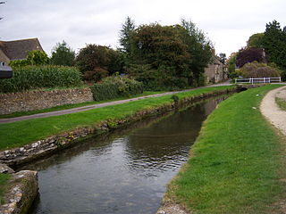
Ashton Keynes is a village and civil parish in north Wiltshire, England which borders with Gloucestershire. The village is about 5 miles (8 km) south of Cirencester and 3.5 miles (5.6 km) west of Cricklade. At the 2011 census the population of the parish, which includes the hamlet of North End, was 1,400.

<span class="mw-page-title-main">Brinkworth, Wiltshire</span> Village in Wiltshire, England

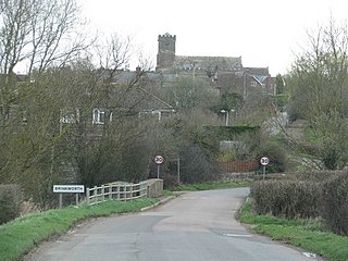
Brinkworth is a village and civil parish in northern Wiltshire, England. The village lies between Royal Wootton Bassett and Malmesbury, about 1 mile (1.6 km) north of the M4 motorway and 9 miles (14 km) west of Swindon.

<span class="mw-page-title-main">Hilmarton</span> Human settlement in England

Hilmarton is a village and civil parish in North Wiltshire, in the west of England. The village lies on the A3102 between the towns of Calne and Wootton Bassett, and 2 miles (3.2 km) south of Lyneham. The parish includes the village of Goatacre and the hamlets of Catcomb, Clevancy, Highway and New Zealand.

<span class="mw-page-title-main">Stoke Common Meadows</span> Protected area in Wiltshire, England

Stoke Common Meadows is a biological Site of Special Scientific Interest in north Wiltshire, England. The 10.2 hectare site is in Purton parish, 1.6 miles (2.6 km) west of Purton Common hamlet and 3 miles (5 km) south-west of the town of Cricklade.

Restrop Farm and Brockhurst Wood is a 56.5 hectare biological Site of Special Scientific Interest in Wiltshire, England, about one mile (1.6 km) south-west of Purton village.

<span class="mw-page-title-main">Minety</span> Village in Wiltshire, England

Minety (/'maɪn.tiː/) is a village in north Wiltshire, England, between Malmesbury – 6 miles (9.7 km) to the west – and Swindon. It takes its name from the water mint plant found growing in ditches around the village, and has previously been known as Myntey. It has a primary school and a successful rugby club.

<span class="mw-page-title-main">Bradenstoke</span> Village in Wiltshire, England

Bradenstoke is a village in Wiltshire, England, lying to the north of the former RAF Lyneham airbase and 1.5 miles (2.4 km) northwest of Lyneham. Originally lying within Braydon Forest, the "stoke" means "settlement".

<span class="mw-page-title-main">Purton Stoke</span> Human settlement in England

Purton Stoke is a small village in north Wiltshire, England, within the civil parish of Purton. The village lies along a side road off the Purton to Cricklade road, approximately 1.5 miles (2.4 km) north of Purton village. A lane gives access to the nearby hamlet of Bentham, to the southwest.

<span class="mw-page-title-main">Marston Meysey</span> Village in Wiltshire, England

Marston Meysey, pronounced and sometimes also spelt Marston Maisey, is a village and civil parish in Wiltshire, England, lying 3 miles (5 km) northeast of Cricklade on the county boundary with Gloucestershire. The parish includes the hamlet of Marston Hill. Marston Maisey is the spelling for the civil parish, but not for the village on Ordnance Survey maps.

<span class="mw-page-title-main">Braydon</span> Human settlement in England

Braydon is a civil parish in north Wiltshire, England, about 6 miles (10 km) northwest of Swindon, between Purton and Minety. A thinly-populated farming area with no settlements apart from the farms, it is best known for sharing its name with Braydon Forest.

The Forest of Braydon is an historic royal hunting forest in Wiltshire, England, the remnant of which lies about 6 miles north-west of Swindon. In medieval times it encompassed about 30,000 acres.

<span class="mw-page-title-main">Lydiard Millicent</span> Village in Wiltshire, England

Lydiard Millicent is a village and civil parish in Wiltshire, England, about 3+12 miles (6 km) west of the centre of Swindon. The parish contains the hamlets of Lydiard Green, Lydiard Plain, Greatfield and Green Hill; in the northeast the parish extends to Common Platt, which is now contiguous with the Peatmoor area of Swindon.

<span class="mw-page-title-main">Leigh, Wiltshire</span> Village in Wiltshire, England

Leigh is a village and civil parish in north Wiltshire, England, 1.5 miles (2.4 km) southeast of Ashton Keynes and 2.5 miles (4 km) west of Cricklade. It is on the edge of the Cotswold Water Park and near to the county border with Gloucestershire. The parish includes the hamlet of Waterhay.

<span class="mw-page-title-main">St Mary's Church, Purton</span> Church in Wiltshire, England

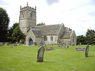
St Mary's Church in the village of Purton in north Wiltshire, England, is an active Church of England parish church in the Diocese of Bristol. A large building begun in the 13th century and one of only three churches in England to have both a western tower and a central spire, it has been designated as a Grade I listed building by English Heritage.

<span class="mw-page-title-main">Crudwell</span> Village in England

Crudwell is a village and civil parish in north Wiltshire, England. The nearest towns are Malmesbury, about 4 miles (6.4 km) to the south-west, and Cirencester, Gloucestershire 8 miles (13 km) to the north-east. Also to the north-east is Cotswold Airport. Kemble village, about 4 miles (6.4 km) away, has the nearest railway station, with services to London Paddington and Gloucester.

<span class="mw-page-title-main">Hankerton</span> Village in Wiltshire, England

Hankerton is a village and civil parish in Wiltshire, England, 3 miles (4.8 km) northeast of Malmesbury. The parish includes the hamlets of Cloatley, Cloatley End and Bullock's Horn.

Nevil Maskelyne was an English landowner and politician who sat in the House of Commons in 1660.

References

  1. "Parish population 2021". City Population. Retrieved 17 December 2024.
  2. "Monument Number 216492". Heritage Gateway. Historic England. Retrieved 27 January 2023.
  3. 1 2 3 4 5 6 7 "Purton". Wiltshire Community History. Wiltshire Council. Retrieved 9 March 2022.
  4. Oakley, Mike (2004). Wiltshire Railway Stations. Wimbourne: The Dovecote Press. pp. 104–105. ISBN   1-904349-33-1.
  5. 1 2 3 4 Bainbridge, Virginia, ed. (2011). "Historic Parishes – Purton with Braydon". A History of the County of Wiltshire, Volume 18. Victoria County History. University of London. pp. 244–285. Retrieved 19 September 2021 via British History Online.
  6. "Blakehill Farm including Stoke Common Meadow". Wiltshire Wildlife Trust. Retrieved 27 January 2023.
  7. "Key Services". Purton Parish Council. Retrieved 25 January 2023.
  8. 1 2 "Election Maps: Great Britain". Ordnance Survey. Retrieved 26 July 2024.
  9. "Purton Ward - 2011 Census". Neighbourhood Statistics. Office for National Statistics. Retrieved 12 January 2016.
  10. 1 2 Fitzgerald, Ben (21 September 2016). "First children and staff at Ridgeway Farm Primary School". swindonlink.com. Retrieved 25 January 2023.
  11. "Church of St. Mary, Purton". Wiltshire Community History. Wiltshire Council. Retrieved 16 January 2016.
  12. Historic England. "Church of St Mary, Purton (1283956)". National Heritage List for England. Retrieved 16 January 2016.
  13. "Quakers, Purton Stoke". Wiltshire Community History. Wiltshire Council. Retrieved 16 January 2016.
  14. "Congregational Chapel, Purton". Wiltshire Community History. Wiltshire Council. Retrieved 16 January 2016.
  15. "Primitive Methodist Chapel, Purton". Wiltshire Community History. Wiltshire Council. Retrieved 16 January 2016.
  16. "Wesleyan Methodist Chapel, Purton". Wiltshire Community History. Wiltshire Council. Retrieved 16 January 2016.
  17. Historic England. "College Farmhouse (1198361)". National Heritage List for England. Retrieved 27 January 2023.
  18. Orbach, Julian; Pevsner, Nikolaus; Cherry, Bridget (2021). Wiltshire. The Buildings Of England. New Haven, US and London: Yale University Press. pp. 515–518. ISBN   978-0-300-25120-3. OCLC   1201298091.
  19. Historic England. "Pound Farmhouse (1023175)". National Heritage List for England. Retrieved 27 January 2023.
  20. Historic England. "Pond Farmhouse (1356025)". National Heritage List for England. Retrieved 27 January 2023.
  21. Historic England. "Restrop House (1356028)". National Heritage List for England. Retrieved 27 January 2023.
  22. "Bradon Forest School, Purton". Wiltshire Community History. Wiltshire Council. Retrieved 15 January 2016.
  23. Wiles, David (18 December 2011). "Two school departments reunite after years apart". Swindon Advertiser. Retrieved 15 January 2016.
  24. "St.Mary's C. of E. Primary School, Purton". Wiltshire Community History. Wiltshire Council. Retrieved 15 January 2016.
  25. "Jubilee Gardens Project" . Retrieved 15 January 2016.
  26. "Nature Reserves". Wiltshire Wildlife Trust. Retrieved 15 January 2016.
  27. Historic England. "The Angel public house (1283866)". National Heritage List for England . Retrieved 15 January 2016.
  28. "Purton Youth FC" . Retrieved 15 January 2023.
  29. Purton Tennis Club
  30. Purton Cricket Club
  31. "Purton 1st XI". Wiltshire County Cricket League. Retrieved 21 January 2023.
  32. "Purton Bowls Club" . Retrieved 8 March 2022.
  33. "Wiltshire's Sports Stars". Wiltshire and Swindon History Centre . 24 January 2014. Retrieved 20 January 2023.
  34. "No. 41951". The London Gazette . 9 February 1960. p. 1022.
  35. Crittall, Elizabeth, ed. (1959). "Spas and mineral springs". A History of the County of Wiltshire, Volume 4. Victoria County History. University of London. pp. 386–388. Retrieved 26 January 2023 via British History Online.
  36. Historic England. "Salt's Hole (1023187)". National Heritage List for England. Retrieved 26 January 2023.

Sources and further reading