Grange Lane railway station (South Yorkshire)

Last updated

Grange Lane
Grange Lane Station - platform buildings 09-05-06.jpg
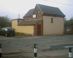
The platform buildings in 2006
General information
Location Ecclesfield, City of Sheffield
England
Coordinates 53°26′16″N1°26′13″W / 53.43785°N 1.43697°W / 53.43785; -1.43697 Coordinates: 53°26′16″N1°26′13″W / 53.43785°N 1.43697°W / 53.43785; -1.43697
Grid reference SK375936
Platforms2
Other information
StatusDisused
History
Original company South Yorkshire Railway & River Dun Navigation
Pre-grouping Great Central Railway
Post-grouping London and North Eastern Railway
Key dates
June 1855Opened
7 December 1953Closed

Grange Lane railway station was a railway station located on the South Yorkshire Railway line between Sheffield and Barnsley in South Yorkshire, England. At the time of its building it was located alongside the lane from which it takes its name with few houses nearby. From the early 1890s it became the interchange point with coal traffic from Grange Colliery at Kimberworth in Rotherham, South Yorkshire. The colliery was sunk in 1891 and coal production ceased in 1963. The colliery site is now Grange Park golf course.

The station, opened in June 1855, consisted of two flanking platforms with buildings on each. The line and the crossing gates were controlled from a signal box situated at the end of the platform adjacent to the gates.

The station was closed on 7 December 1953 [1] and most buildings existed until late 2011; the station building is a private residence.

Grange Lane station building and level crossing. Grange Lane Station - platforms 22-04-06.jpg
Grange Lane station building and level crossing.

Related Research Articles

Leeds railway station Mainline railway station in Leeds, West Yorkshire, England

Leeds railway station is the mainline railway station serving the city centre of Leeds in West Yorkshire, England. It is the fourth-busiest railway station in the UK outside London. It is located on New Station Street to the south of City Square, at the foot of Park Row, behind the landmark Queens Hotel. It is one of 20 stations managed by Network Rail.

Elsecar Village in South Yorkshire, England

Elsecar is a village in the Metropolitan Borough of Barnsley in South Yorkshire, England. It is near the villages of Jump and Wentworth and 1.5 miles (2.4 km) south of the town of Hoyland, 6 miles (9.7 km) south of Barnsley and 8 miles (13 km) north-east of Sheffield. Elsecar falls within the Barnsley MBC Ward of Hoyland Milton. Like many villages in the area, it was for many years a colliery village until the widespread pit closures during the 1980s.

Rossington Civil parish and former mining village in South Yorkshire, England

Rossington is a civil parish and former mining village in the Metropolitan Borough of Doncaster in South Yorkshire, England and is surrounded by countryside and the market towns of Bawtry and Tickhill.

North Tyneside Steam Railway Visitor attraction in North East England

The North Tyneside Steam Railway and Stephenson Steam Railway are visitor attractions in North Tyneside, North East England. The museum and railway workshops share a building on Middle Engine Lane adjacent to the Silverlink Retail Park. The railway is a standard gauge line, running south for 2 miles (3.2 km) from the museum to Percy Main. The railway is operated by the North Tyneside Steam Railway Association (NTSRA). The museum is managed by Tyne and Wear Archives and Museums on behalf of North Tyneside Council.

Elsecar Heritage Railway Railway line in South Yorkshire, England

The Elsecar Heritage Railway (EHR) is located on the southern part of the former South Yorkshire Railway freight-only branch which ran from Elsecar Junction on its Mexborough to Barnsley Line.

<span class="mw-page-title-main">Woodhouse railway station</span> Railway station in South Yorkshire, England

Woodhouse railway station serves Woodhouse and Woodhouse Mill in Sheffield, South Yorkshire, England. The station is 5.25 miles (8 km) east of Sheffield station on the Sheffield to Lincoln Line.

Woodlesford railway station Railway station in West Yorkshire, England

Woodlesford railway station serves Woodlesford and Rothwell in West Yorkshire, England. It lies on the Hallam Line and the Pontefract Line, 6 miles (9.7 km) south of Leeds.

<span class="mw-page-title-main">Pontefract Tanshelf railway station</span> Railway station in West Yorkshire, England

Pontefract Tanshelf railway station is the most central station in the town of Pontefract, West Yorkshire, England, and serves Pontefract Races, the racecourse located just down the street from the station. It lies on the Pontefract Line operated by Northern and is 8 miles (13 km) east of Wakefield Kirkgate. In the days of coal mining in the Pontefract area, the station served the needs of the local workforce with regular and frequent services timed for the beginning and the end of mining shifts. The station is the closest to the former Prince of Wales Colliery which closed in 2002. The station serves Beechnut Lane, the home ground of Pontefract Collieries F.C.

<span class="mw-page-title-main">Knottingley railway station</span> Railway station in West Yorkshire, England

Knottingley railway station serves the town of Knottingley in West Yorkshire, England. It lies on the Pontefract Line, operated by Northern, and is 16 miles (26 km) south east of Leeds railway station.

Dodworth railway station Railway station in South Yorkshire, England

Dodworth railway station serves the village of Dodworth, in the Metropolitan Borough of Barnsley, South Yorkshire, England. The station is 2 miles 71 chains (4.6 km) west of Barnsley on the Penistone Line between Huddersfield and Sheffield.

<span class="mw-page-title-main">Middleton Railway</span> Railway line in Leeds, England

The Middleton Railway is the world's oldest continuously working railway, situated in the English city of Leeds. It was founded in 1758 and is now a heritage railway, run by volunteers from The Middleton Railway Trust Ltd. since 1960.

Caphouse Colliery

Caphouse Colliery, originally known as Overton Colliery, was a coal mine in Overton, near Wakefield, West Yorkshire, England. It was situated on the Denby Grange estate owned by the Lister Kaye family, and was worked from the 18th century until 1985. It reopened as the Yorkshire Mining Museum in 1988, and is now the National Coal Mining Museum for England.

Netherton, Wakefield Human settlement in England

Netherton is a village in the City of Wakefield metropolitan borough of West Yorkshire, England. It lies about 4 miles south-west of Wakefield, 3 miles south of Ossett, 1 mile south of Horbury. The village is in the Wakefield Rural ward of Wakefield Metropolitan District Council. The village name is shown on map "Dvcatvs Eboracensis pars occidentalis" from 1646.

Outwood, Wakefield Settlement in West Yorkshire, England

Outwood is a district to the north of Wakefield, a city in West Yorkshire, England. The district is centred on the A61 Leeds Road south of Lofthouse. It grew up as a pit village and was only a small settlement until the 1970s, when construction of new houses caused it to grow and merge with neighbouring settlements such as Wrenthorpe and Stanley. In 2001, it had a population of 7,623.

Ellistown is a village about 2 miles (3 km) south of Coalville in North West Leicestershire, England. It is named after Colonel Joseph Joel Ellis who died in 1885. The population from the 2011 census was included in the civil parish of Ellistown and Battleflat.

The South Yorkshire Railway was a railway company with lines in the West Riding of Yorkshire, England.

Greasbrough Canal

The Greasbrough Canal was a private canal built by the Marquess of Rockingham to serve his coal mining interests in and around the village of Greasbrough, near Rotherham, South Yorkshire, England. It opened in 1780, and the Newbiggin branch was built some time later. The main line to Greasbrough closed in 1840 with the coming of the Sheffield and Rotherham Railway, and the canal ceased to carry commercial traffic during the First World War. Most of it has been filled in, but a small section near the River Don Navigation remains in water.

Robin Hood is a village in West Yorkshire, England, within the City of Leeds metropolitan borough, with Wakefield WF3, and Leeds LS26 postcodes. It is situated on the A61 and A654 between Leeds and Wakefield, close to Rothwell and Lofthouse.

Copmanthorpe railway station Disused railway station in North Yorkshire, England

Copmanthorpe railway station served the village of Copmanthorpe, North Yorkshire, England from 1839 to 1959 on the York to Normanton line. The line also became part of the East Coast Main Line at various periods. The station was moved and substantially rebuilt halfway through its working life.

Bowers railway station was a station opened in 1934 by the London and North Eastern Railway (LNER) on the Castleford–Garforth line, in the West Riding of Yorkshire, England. It was only open for 17 years, being closed in January 1951, though the line remained open until the 1990s for coal traffic from the nearby collieries.

References

  1. Quick, M E (2002). Railway passenger stations in England, Scotland and Wales – a chronology. Richmond: Railway and Canal Historical Society. p. 203. OCLC   931112387.