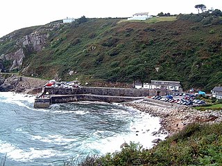
Lamorna is a village, valley and cove in west Cornwall, England, UK. It is on the Penwith peninsula approximately 4 miles (6 km) south of Penzance. Lamorna became popular with the artists of the Newlyn School, including Alfred Munnings, Laura Knight and Harold Knight, and is also known for former residents Derek and Jean Tangye who farmed land and wrote "The Minack Chronicles".
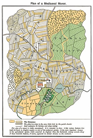
The open-field system was the prevalent agricultural system in much of Europe during the Middle Ages and lasted into the 20th century in Russia, Iran, and Turkey. Each manor or village had two or three large fields, usually several hundred acres each, which were divided into many narrow strips of land. The strips or selions were cultivated by peasants, often called tenants or serfs. The holdings of a manor also included woodland and pasture areas for common usage and fields belonging to the lord of the manor and the religious authorities, usually Roman Catholics in medieval Western Europe. The farmers customarily lived in separate houses in a nucleated village with a much larger manor house and church nearby. The open-field system necessitated co-operation among the residents of the manor.

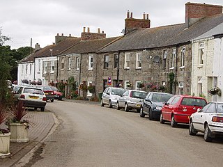
Porthleven is a town, civil parish and fishing port near Helston, Cornwall, England, United Kingdom. The most southerly port in Great Britain, it was a harbour of refuge when this part of the Cornish coastline was infamous for wrecks in the days of sail. The South West Coast Path from Somerset to Dorset passes through the town. The population at the 2011 census was 3,059.

The Howardian Hills are an Area of Outstanding Natural Beauty (AONB) in England located between the Yorkshire Wolds, the North York Moors National Park, and the Vale of York. They are named after the Howard family who still own local lands.

A croft is a traditional Scottish term for a fenced or enclosed area of land, usually small and arable, and usually, but not always, with a crofter's dwelling thereon. A crofter is one who has tenure and use of the land, typically as a tenant farmer, especially in rural areas.

Crackington Haven is a coastal village in Cornwall, England, United Kingdom. It is in the civil parish of St Gennys at grid reference SX140972 at the head of a cove on the Atlantic coast. The village is seven miles (11 km) south-southwest of Bude and four miles (7 km) north-northeast of Boscastle.

St Levan is a civil parish in Cornwall, England, United Kingdom. The parish is rural with a number of hamlets of varying size with Porthcurno probably being the best known. Hewn out of the cliff at Minack Point and overlooking the sea to the Logan Rock is the open-air Minack Theatre, the inspiration of Rowena Cade in the early 1930s.

Braddock is a village and civil parish in Cornwall, England, United Kingdom. The village is about seven miles west of Liskeard, and five miles south-east of Bodmin. The parish was called Broadoak until 1 April 2021.

Mullion is a civil parish and village on the Lizard Peninsula in south Cornwall, England, United Kingdom. The nearest town is Helston approximately 5 miles (8 km) to the north.

Farleigh is a village and former civil parish, now in the parish of Chelsham and Farleigh in the Tandridge district of Surrey, England. It is located in the North Downs AONB and the Metropolitan Green Belt, 4.5 miles (7.2 km) south east of Croydon, 13.4 miles (21.6 km) south of London and 25 miles (40 km) WNE of Surrey's county town, Guildford. In 1961 the parish had a population of 1285.

Kerris is a settlement in west Cornwall, England, United Kingdom. It is three miles (5 km) south-west of Penzance in the civil parish of Paul. Kerris means "fort-place" in the Cornish language.

Towan is found in many placenames in Cornwall. However, The Towans usually refers to the three-mile (5 km) stretch of coastal dunes which extends north-east from the estuary of the River Hayle to Gwithian beach with a midpoint near Upton. The South West Coast Path crosses the towans.

Gurnard's Head is a prominent headland on the north coast of the Penwith peninsula in Cornwall, England. The name is supposed to reflect that the rocky peninsula resembles the head of the gurnard fish.

Widford is an area of Chelmsford and former civil parish, in the City of Chelmsford district in the county of Essex, England. It is approximately 1.5 miles (2.4 km) south-south-west of the city's railway station. It encloses a mixed residential, industrial and rural area south of the River Can, east of the River Wid and mostly to the west of the Great Eastern Main Line. In 1931 the parish had a population of 457.
Gwinear is a small village and former civil parish, now in the parish of Gwinear-Gwithian, in the Cornwall district, in west Cornwall, England, UK. It is about two miles (3 km) east of Hayle and overlooks the Angarrack valley. In 1931 the parish had a population of 1234. On 1 April 1934 the parish was abolished to form "Gwinear Gwithian".

Catchall is a hamlet in west Cornwall, England, UK. Catchall is 1 mile (1.6 km) south-east of Sancreed at around 310 feet (94 m) above sea level at the junction of the B3283 with the A30 main road.

Grumbla is a hamlet in the parish of Sancreed, Cornwall, England, UK.

Little Bosullow is a hamlet in the civil parish of Madron, Cornwall, England, UK. Great Bosullow is to the west, Bosullow is on the B3312 Madron to Morvah road and Bosullow Common is to the north.

Higher Ninnes and Lower Ninnes are hamlets, south of Mulfra Hill in the civil parish of Madron in west Cornwall, England, UK.

Relubbus is a hamlet in the parish of St Hilary, west Cornwall, England. It is on the B3280 road between Townshend and Goldsithney; the River Hayle runs through Relubbus.

