
Cornwall is a town in Orange County, New York, United States, approximately 50 miles (80 km) north of New York City on the western shore of the Hudson River. As of the 2020 census, the population was at 12,884. Cornwall has become a bedroom community for area towns and cities including New York City. Commuter rail service to North Jersey and New York City is available via the Salisbury Mills–Cornwall train station, operated by NJ Transit on behalf of Metro-North Railroad. The town is located less than an hour from the George Washington Bridge with access to major commuter routes such as the New York State Thruway and the Palisades Parkway.

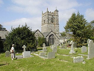
St Columb Major is a town and civil parish in Cornwall, England, United Kingdom. Often referred to locally as St Columb, it is approximately seven miles (11 km) southwest of Wadebridge and six miles (10 km) east of Newquay The designation Major distinguishes it from the nearby settlement and parish of St Columb Minor on the coast. An electoral ward simply named St Columb exists with a population at the 2011 census of 5,050. The town is named after the 6th-century AD Saint Columba of Cornwall, also known as Columb.

Advent is a civil parish on the north-western edge of Bodmin Moor in north Cornwall, England. The English name St Adwenna derives from the Cornish Adhwynn and lies in the Registration District of Camelford.
Blisland is a village and civil parish in Cornwall, England, United Kingdom. It is approximately five miles northeast of Bodmin. According to the 2001 census, the parish had a population of 565. This had increased to 608 at the 2011 census.
Delabole is a large village and civil parish in north Cornwall, England, which lies approximately two miles (3 km) west of Camelford.
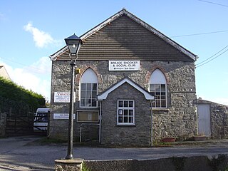
Breage is a civil parish and village in Cornwall, England. The village is three miles (5 km) west of Helston.
Banns is a hamlet in west Cornwall, England, United Kingdom situated between Mount Hawke and Porthtowan at grid reference SW 710 480 in the civil parish of St Agnes. The South West Coast Path is 2 km (1.2 mi) to the west of the hamlet. Banns is included in the Mount Hawke and Portreath division of Cornwall Council.
Crugmeer is a hamlet in north Cornwall, England, United Kingdom. It is situated one-and-a-half miles from Padstow to the west of the River Camel estuary.

St Pinnock is a hamlet and civil parish in southeast Cornwall, England, 3 miles (5 km) south-west of Liskeard. Other settlements in the parish include East Taphouse, and Penfrane, containing 421 inhabitants. The parish church, dedicated to St Pynnochus (Winnoc), is located at OS Grid Ref SX200630.

The 1944 Cornwall–Massena earthquake occurred on September 5 at 12:38:45 am EDT in Massena, New York. It registered 5.8 on the moment magnitude scale and had a maximum Mercalli intensity of VIII (Severe). This area is part of the Saint Lawrence River Valley and the seismically active zone known as the Saint Lawrence rift system. The earthquake is the largest known in New York's recorded history and was felt over great distances.
The Great County Adit, sometimes called the County Adit, or the Great Adit was a system of interconnected adits that helped drain water from the tin and copper mines in the Gwennap area of Cornwall, in the United Kingdom. Construction started in 1748 and it eventually reached a length of over 40 miles (64 km) of a tunnel, providing drainage to over 100 mines at an average depth of 80–100 metres (260–330 ft).

Millpool is a hamlet in the parish of Cardinham in north Cornwall, England, lying about one mile north of Cardinham village. The A30 trunk road towards Bodmin runs about half a mile north-west of the hamlet.

Pennance is a hamlet near Lanner in west Cornwall, England.
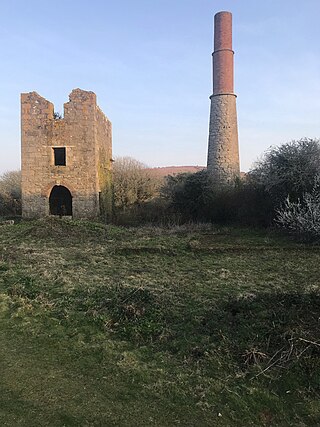
Great Work Mine was a Cornish mine between Godolphin hill and Tregonning Hill and is in the hamlet of Great Work on Bal Lane. Great Work is notable for its unusual chimney stack with the upper brick-work in two stages. The remaining ruin of the mine sits 400 ft above sea level, and is part of the Cornwall and West Devon Mining Landscape.
Ludgvan was an electoral division of Cornwall in the United Kingdom which returned one member to sit on Cornwall Council between 2009 and 2021. It was abolished at the 2021 local elections, being split between Ludgvan, Madron, Gulval and Heamoor, Long Rock, Marazion and St Erth, St Ives East, Lelant and Carbis Bay, and St Ives West and Towednack.

Breage, Germoe and Sithney was an electoral division of Cornwall in the United Kingdom which returned one member to sit on Cornwall Council between 2013 and 2021. It was abolished at the 2021 local elections, being succeeded by Porthleven, Breage and Germoe and Crowan, Sithney and Wendron.
Newlyn and Goonhavern was an electoral division of Cornwall in the United Kingdom and returned one member to sit on Cornwall Council. It was abolished in 2021.


