
The Ordnance Survey National Grid reference system is a system of geographic grid references used in Great Britain, distinct from latitude and longitude. It is often called British National Grid (BNG).

Virginstow is a village and civil parish in the Torridge district of Devon, England. It is situated about 7 miles north of Launceston in Cornwall. According to the 2001 census it had a population of 115.

The River Hayle is a small river in West Cornwall, England, United Kingdom which issues into St Ives Bay at Hayle on Cornwall's Atlantic coast.

Whitesand Bay is a wide sandy bay near Land's End in west Cornwall, England, United Kingdom. It stretches for one mile between the headlands of Pedn-mên-du and Aire Point. and contains the village of Sennen Cove. It is also a landing point for the Atlantic Crossing 1 international telecommunications cable.
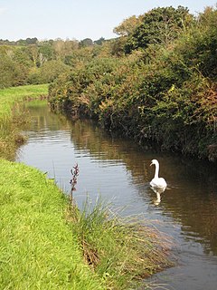
The River Cober is a short river in west Cornwall, England, United Kingdom. It rises in Nine Maidens Downs, directly between Hangman's Barrow to the west and the Nine Maidens stone circle to the east, in the former Kerrier District and runs to the west of the town of Helston before entering the largest natural lake in Cornwall – Loe Pool. The water is impounded by the natural barrier, Loe Bar, and the river system can be traced several kilometres out into Mount's Bay. Mining activity of over one hundred years in the river catchment, ceased in 1938, in the Wendron and Porkellis mining districts; and the engine house of Castle Wary, near Nansloe can still be seen on the east side of the river below Helston. The lower reaches of river was canalised in 1946 and a causeway built over Loe Marsh in 1987. The meaning of the name is uncertain, but two of the earliest records are: "in 1260 we find, 'Chohor' and a few years later, 'Coffar'". The present name 'Cober' is unlikely to be derived from 'Coffar', since it was known as the 'River Loe or River Looe' around four hundred years ago, in Carew's time, according to the map of Powder Hundred.

The River Allen in north Cornwall is one of two rivers of the same name in Cornwall which share this name. In this case the name is the result of a mistake made in 1888 by Ordnance Survey, replacing the name Layne with Allen which is the old name for the lower reaches of the Camel. The other River Allen runs through Truro.

The De Lank River is a small river in north Cornwall, England. It is a tributary of the River Camel and is approximately nine miles (14.5 km) long from its source on Bodmin Moor to its confluence with the Camel two miles (3 km) south of St Breward.

Carnebone is a small hamlet and farm in the parish of Wendron in Cornwall, England. It lies to the east of Wendron, to the northeast of Trevenen, just to the west of Seworgan, along the A394 road, 3.8 miles (6.1 km) northeast of Helston.

Common Moor or Commonmoor is a Village in Cornwall, England. It is about a mile north of St Cleer It does not have a public telephone box or post office but does have a letter box. The village meeting place in Commonmoor is a small village hall. It is a very old mining village founded by the Davy family, traces of its past are still visible from placenames like "Davy's Row".

Coxpark is a hamlet in the parish of Calstock, Cornwall, England.
Enniscaven is a hamlet that lies 5 miles (8.0 km) north-west of St Austell in Cornwall, England. Enniscaven is in the civil parish of St Dennis. The village is near to Goss Moor which is the largest continuous mire complex in south-west Britain. Goss Moor is part of the Goss And Tregoss Moors Site of Special Scientific Interest (SSSI) which is also a Special Area of Conservation (SAC).
Farms Common is a hamlet in the parish of Wendron, Cornwall, England.

Great Bosullow is a hamlet south-east of Morvah in west Cornwall, England, UK. Bosullow Common is an extensive area of heathland. Great Bosullow lies within the Cornwall Area of Outstanding Natural Beauty (AONB). Almost a third of Cornwall has AONB designation, with the same status and protection as a National Park.

Little Bosullow is a hamlet in the civil parish of Madron, Cornwall, England, UK. Great Bosullow is to the west, Bosullow is on the B3312 Madron to Morvah road and Bosullow Common is to the north.

Polwheveral is a hamlet near Constantine in Cornwall, England. Polwheveral is at the head of a creek of the Helford River.

Breney Common is a nature reserve and Site of Special Scientific Interest, noted for its biological characteristics, in mid Cornwall, England, UK. It is located mainly in Lanlivery civil parish, with the Saints' Way footpath running through it.

Carrine Common & Penwethers is a Site of Special Scientific Interest (SSSI) in Cornwall, England, UK, noted for its biological characteristics. The 46-hectare (110-acre) site is located by the settlement of Penweathers, within the civil parish of Kea, half a mile south of the city of Truro.
Retire Common is a Site of Special Scientific Interest, noted for its biological characteristics, in mid Cornwall, England, UK.

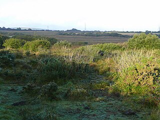
Kelsey Head is a coastal Site of Special Scientific Interest (SSSI) and headland in north Cornwall, England, UK, noted for its biological interest. The site contains an Iron Age hill fort.

The River Kensey is a river in east Cornwall, England, UK which is a tributary of the River Tamar.
