Grier City-Park Crest, Pennsylvania

Last updated
Grier City-Park Crest
Former CDP
USA Pennsylvania location map.svg
Red pog.svg
Grier City-Park Crest
Location within the U.S. state of Pennsylvania
Coordinates: 40°49′9″N76°3′29″W / 40.81917°N 76.05806°W / 40.81917; -76.05806 Coordinates: 40°49′9″N76°3′29″W / 40.81917°N 76.05806°W / 40.81917; -76.05806
Country United States
State Pennsylvania
County Schuylkill
Population
 (2000)
  Total954
Time zone UTC-5 (Eastern (EST))
  Summer (DST) UTC-4 (EDT)
ZIP code
18214
Area code(s) 570

Grier City-Park Crest was a census-designated place (CDP) in Schuylkill County, Pennsylvania, United States. [1] The population was 954 at the 2000 census. For the 2010 census the area was split into two CDPs, Grier City and Park Crest.

Contents

Geography

According to the United States Census Bureau, the CDP had a total area of 1.7 square miles (4.4 km2), of which 1.7 square miles (4.4 km2) was land and 0.04 square miles (0.10 km2), or 1.16%, was water.

Demographics

As of the census [2] of 2000, there were 954 people, 381 households, and 283 families residing in the CDP. The population density was 555.9 people per square mile (214.2/km2). There were 413 housing units at an average density of 240.6/sq mi (92.7/km2). The racial makeup of the CDP was 99.79% White and 0.21% from two or more races. Hispanic or Latino of any race were 0.31% of the population.

There were 381 households, out of which 27.3% had children under the age of 18 living with them, 59.6% were married couples living together, 10.5% had a female householder with no husband present, and 25.7% were non-families. 21.5% of all households were made up of individuals, and 11.0% had someone living alone who was 65 years of age or older. The average household size was 2.50 and the average family size was 2.93.

In the CDP, the population was spread out, with 20.8% under the age of 18, 6.2% from 18 to 24, 25.4% from 25 to 44, 31.1% from 45 to 64, and 16.6% who were 65 years of age or older. The median age was 44 years. For every 100 females, there were 91.2 males. For every 100 females age 18 and over, there were 92.9 males.

The median income for a household in the CDP was $42,574, and the median income for a family was $47,045. Males had a median income of $35,435 versus $21,944 for females. The per capita income for the CDP was $17,443. About 9.9% of families and 9.7% of the population were below the poverty line, including 15.4% of those under age 18 and 15.7% of those age 65 or over.

Related Research Articles

Forestdale, Alabama Census-designated place & Unincorporated community in Alabama, United States

Forestdale is an unincorporated community and census-designated place (CDP) in Jefferson County, Alabama, United States. It is north of the Birmingham city neighborhood of Ensley. At the 2020 census, the population was 10,409.

Blackhawk-Camino Tassajara, California Former census-designated place in California, United States

Blackhawk-Camino Tassajara is a former census-designated place (CDP) in Contra Costa County, California, near the town of Danville. The unincorporated area consisted of the Blackhawk planned community and the surrounding Camino Tassajara area. As of the 2000 census, the CDP's population was 10,048. The CDP was split between Blackhawk and Camino Tassajara prior to the 2010 census.

West Rancho Dominguez, California Census designated place in California, United States

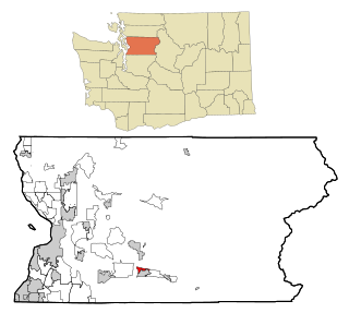
West Rancho Dominguez, formerly known as West Compton, is an unincorporated census-designated place (CDP) located in southern Los Angeles County, California. Per the 2020 census, the population was 24,347. The community lies to the west of the city of Compton. The ZIP Codes encompassing the CDP area are 90220 & 90248.

Crest, California Census-designated place in California, United States

Crest is an unincorporated community in San Diego County, California. The Crest census-designated place (CDP) had a population of 2,593 at the 2010 census, down from 2,716 at the 2000 census.

Wahneta, Florida Census-designated place in Florida, United States

Wahneta is a census-designated place (CDP) in central Polk County, Florida, United States. The population was 4,731 at the 2000 census. It is part of the Lakeland–Winter Haven Metropolitan Statistical Area.

Masonville, Kentucky Census-designated place in Kentucky, United States

Masonville is an unincorporated community and census-designated place (CDP) in Daviess County, Kentucky, United States. The population was 1,014 at the 2010 census. It is included in the Owensboro Metropolitan Statistical Area.

Sewaren, New Jersey Census-designated place in New Jersey, United States

Sewaren is an unincorporated community and census-designated place (CDP) within Woodbridge Township, in Middlesex County, New Jersey, United States. As of the 2010 United States Census, the CDP's population was 2,756.

North Middletown, New Jersey Census-designated place in New Jersey, United States

North Middletown is an unincorporated community and census-designated place (CDP) within Middletown Township, in Monmouth County, New Jersey, United States. As of the 2010 United States Census, the CDP's population was 3,295.

Cedar Crest, New Mexico Census-designated place in New Mexico, United States

Cedar Crest is a census-designated place (CDP) in Bernalillo County, New Mexico, United States. The population was 958 at the 2010 census. It is part of the Albuquerque Metropolitan Statistical Area.

Bunker Hill, Oregon CDP in Oregon, United States

Bunker Hill is a census-designated place (CDP) in Coos County, Oregon, United States. As of the 2010 census the population was 1,444.

Richboro, Pennsylvania Census-designated place in Pennsylvania, United States

Richboro is a census-designated place (CDP) in Northampton Township, Bucks County, Pennsylvania, United States. The population was 6,378 during the 20200 census.

Lincolnville, Pennsylvania Census-designated place in Pennsylvania, United States

Lincolnville is a census-designated place in Crawford County, Pennsylvania, United States. The population was 96 at the 2010 census.

Lake Marcel-Stillwater, Washington Census-designated place in Washington, United States

Lake Marcel-Stillwater is a census-designated place (CDP) in King County, Washington, United States. The population was 1,277 at the 2010 census.

Lakeland North, Washington Census-designated place in Washington, United States

Lakeland North is a census-designated place (CDP) in King County, Washington, United States. The population was 12,942 at the 2010 census. Part of the community was annexed into neighboring Auburn in 2008.

Union Hill-Novelty Hill, Washington Census-designated place in Washington, United States

Union Hill-Novelty Hill is a census-designated place (CDP) in King County, Washington, United States. The area was first recognized by the Census Bureau in the 2000 census. The population was 18,805 at the 2010 census.

North Sultan, Washington CDP in Washington, United States

North Sultan is a census-designated place (CDP) in Snohomish County, Washington, United States. The population was 264 at the 2010 census.

Ipswich (CDP), Massachusetts Census-designated place in Massachusetts, United States

Ipswich is a census-designated place (CDP) located in the town of Ipswich in Essex County, Massachusetts, United States. The population was 4,222 at the 2010 census.

Lac du Flambeau (CDP), Wisconsin CDP in Wisconsin, United States

Lac du Flambeau is a census-designated place (CDP) in the town of Lac du Flambeau in Vilas County, Wisconsin, United States. The population was 1,969 at the 2010 census. Lac du Flambeau is the major community for the Lac du Flambeau Band of Lake Superior Chippewa tribe.

Millinocket is a census-designated place (CDP) comprising most of the developed land within the town of Millinocket in Penobscot County, Maine, United States. The population of the CDP was 4,466 at the 2010 census.

Hartland is a census-designated place (CDP) in the town of Hartland in Somerset County, Maine, United States. The population was 872 at the 2000 census.

References

  1. "US Gazetteer files: 2010, 2000, and 1990". United States Census Bureau. 2011-02-12. Retrieved 2011-04-23.
  2. "U.S. Census website". United States Census Bureau . Retrieved 2008-01-31.