Harrison Spring

Last updated
Harrison Spring
Harrison Spring IN.jpg
Harrison Spring
USA Indiana location map.svg
Red pog.svg
Map of Indiana
Typewaterbody
Location Harrison County, Indiana
Nearest city White Cloud
Coordinates 38°14′39″N86°13′30″W / 38.2443°N 86.2251°W / 38.2443; -86.2251
Area7 acres (2.8 ha)
Designated1980

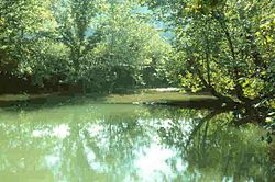
Harrison Spring is the largest spring in the U.S. state of Indiana. It is located in west-central Harrison County, near the Blue River and just north of White Cloud.

Contents

The Spring

Several dye trace studies have shown that the drainage basin of Harrison Spring is, by Indiana standards, very large. Indian Creek is a major infeeder to the Harrison Springs drainage system as the entire summer flow of Indian Creek can disappear at the Sinks of Indian Creek and re-emerge at Harrison Springs in low-flow conditions, in about one hour. Given that Big Indian Creek – upstream of the Sinks of Indian Creek – drains an area between Corydon and Georgetown, as well as Little Indian Creek (an infeeder to Big Indian) drains an area that runs east of Lanesville, the Indian Creek portion of the Harrison Spring drainage basin alone drains an area of at least 200 square miles (520 km2).

The other major known drainage basin is nearly entirely subsurface karst drainage and includes a known area that runs from Harrison Spring to the north and northeast to Ramsey and Central Barren, just 2–3 miles (3.2–4.8 km) south of Palmyra and contains an area of at least 39 square miles (100 km2).

While mapping parts of Binkley's Cave, the largest known cave in Indiana, the cavers of the Indiana Speleological Survey (ISS) have noted that according to their cave mapping data, water in the Blowing Hole section of Binkley's appears to flow under the bed of Indian Creek, near the Sinks of Indian Creek, and resurge at Harrison Spring. This is further proven by dye trace studies performed in the sinkhole plain containing Binkley's Cave.

Surface water that sinks into the sinkhole plain in areas near the intersection of Shiloh Road and Indiana State Road 135 south of Corydon has been observed to flow through known parts of Binkley's Cave, subterraneally under Indian Creek, exit to the surface at Harrison Spring, and flow to the Blue River. There may be a link under Indian Creek between Harrison Spring and Binkley's Cave. However the route would certainly involve many long cave dives – nothing of which on such a scale has ever been attempted in Indiana. Such a connection would likely greatly expand the known lengths of both caves as there are still significant gaps of unexplored cave in between the two systems. Binkley's currently measures around 44 miles (71 km) in length – the longest known cave in Indiana and the seventh longest cave known in the United States – and its known extent is increasing due to the efforts of the ISS. Cave divers led by Dave Strickland have mapped several thousand feet of cave in Harrison Spring – all of which was at a significant depth, and entirely underwater.

The rise pool at Harrison Spring measures approximately 120 feet (37 m) by 95 feet (29 m). It is within an abandoned meander loop of Blue River. Divers have measured its depth to be about 45 feet (14 m). Harrison Spring has an average discharge of 100 cubic feet per second (2.8 m3/s) with a flood discharge of up to 900 cubic feet per second (25 m3/s). The water from the spring overflows into an outlet that travels about 34 mile (1.2 km) before merging with Blue River as a tributary.

History

The spring is privately owned. It was once part of a large 600-acre (2.4 km2) farm owned by United States President William Henry Harrison, from whom it gains its name. The spring produced enough water to run a gristmill and sawmill downstream which began operating 1807, making it one of the first in the state. [1] [2] The farm was known as Harrison Valley. Harrison had planned to make it a plantation similar to Grouseland, and a shipyard. However, the outlawing of slavery by the Indiana Constitution of 1816 made this impossible.

The spring was registered as a National Natural Landmark in 1980, but is not open to the public.

Related Research Articles

<span class="mw-page-title-main">Harrison County, Indiana</span> County in Indiana, United States

Harrison County is located in the far southern part of the U.S. state of Indiana along the Ohio River. The county was officially established in 1808. Its population was 39,654 as of the 2020 United States Census. Its county seat is Corydon, the former capital of Indiana.

<span class="mw-page-title-main">Sinkhole</span> Geologically-formed topological depression

A sinkhole is a depression or hole in the ground caused by some form of collapse of the surface layer. The term is sometimes used to refer to doline, enclosed depressions that are also known as shakeholes, and to openings where surface water enters into underground passages known as ponor, swallow hole or swallet. A cenote is a type of sinkhole that exposes groundwater underneath. Sink and stream sink are more general terms for sites that drain surface water, possibly by infiltration into sediment or crumbled rock.

<span class="mw-page-title-main">St. Johns River</span> The longest river in Florida, United States

The St. Johns River is the longest river in the U.S. state of Florida and it is the most significant one for commercial and recreational use. At 310 miles (500 km) long, it flows north and winds through or borders twelve counties. The drop in elevation from headwaters to mouth is less than 30 feet (9 m); like most Florida waterways, the St. Johns has a very slow flow speed of 0.3 mph (0.13 m/s), and is often described as "lazy".

<span class="mw-page-title-main">Salt River (Arizona)</span> River in Gila and Maricopa counties in Arizona, United States

The Salt River is a river in Gila and Maricopa counties in Arizona, United States, that is the largest tributary of the Gila River. The river is about 200 miles (320 km) long. Its drainage basin covers about 13,700 square miles (35,000 km2). The longest of the Salt River's many tributaries is the 195-mile (314 km) Verde River. The Salt's headwaters tributaries, the Black River and East Fork, increase the river's total length to about 300 miles (480 km). The name Salt River comes from the river's course over large salt deposits shortly after the merging of the White and Black Rivers.

<span class="mw-page-title-main">Current River (Ozarks)</span> River in the U.S. state of Missouri

The Current River forms in the southeastern portion of the Ozarks of Missouri and becomes a 7th order stream as it flows southeasterly out of the Ozarks into northeastern Arkansas where it becomes a tributary of the Black River, which is a tributary of the White River, a tributary of the Mississippi River. The Current River is approximately 184 miles (296 km) long and drains about 2,641 square miles (6,840 km2) of land mostly in Missouri and a small portion of land in northeastern Arkansas. The headwaters of the Current River are nearly 900 feet (270 m) above sea level, while the mouth of the river lies around 280 feet (85 m) above sea level. The basin drains a rural area that is dominated by karst topography, underlain by dolomite and sandstone bedrock with a small area of igneous rock southeast of Eminence, Missouri. The annual daily mean discharge of the river near Doniphan, Missouri is 2,815 cubic feet (79.7 m3) per second. In 1964, over 134 mi (160 km) of the upper course of the river and its tributaries were federally protected as the Ozark National Scenic Riverways, the first national park in America to protect a river system.

<span class="mw-page-title-main">Kankakee River</span> River in Indiana and Illinois, United States

The Kankakee River is a tributary of the Illinois River, approximately 133 miles (214 km) long, in the Central Corn Belt Plains of northwestern Indiana and northeastern Illinois in the United States. At one time, the river drained one of the largest wetlands in North America and furnished a significant portage between the Great Lakes and the Mississippi River. Significantly altered from its original channel, it flows through a primarily rural farming region of reclaimed cropland, south of Lake Michigan.

<span class="mw-page-title-main">Walker River</span> River in Nevada, United States

The Walker River is a river in west-central Nevada in the United States, approximately 62 miles (100 km) long. Fed principally by snowmelt from the Sierra Nevada of California, it drains an arid portion of the Great Basin southeast of Reno and flows into the endorheic basin of Walker Lake. The river is an important source of water for irrigation in its course through Nevada; water diversions have reduced its flow such that the level of Walker Lake has fallen 160 feet (49 m) between 1882 and 2010. The river was named for explorer Joseph Reddeford Walker, a mountain man and experienced scout who is known for establishing a segment of the California Trail.

<span class="mw-page-title-main">Feather River</span> River in California, United States

The Feather River is the principal tributary of the Sacramento River, in the Sacramento Valley of Northern California. The river's main stem is about 73 miles (117 km) long. Its length to its most distant headwater tributary is just over 210 miles (340 km). The main stem Feather River begins in Lake Oroville, where its four long tributary forks join—the South Fork, Middle Fork, North Fork, and West Branch Feather Rivers. These and other tributaries drain part of the northern Sierra Nevada, and the extreme southern Cascades, as well as a small portion of the Sacramento Valley. The total drainage basin is about 6,200 square miles (16,000 km2), with approximately 3,604 square miles (9,330 km2) above Lake Oroville.

<span class="mw-page-title-main">Manatee Springs State Park</span> State park in Florida, United States

Manatee Springs State Park is a Florida State Park located six miles west of Chiefland on SR 320, off US 19. Manatee Spring is a first magnitude spring that flows directly into the Suwannee River by way of a short run. Present also are swamps and hardwood wetlands along the Suwannee, along with many sinkhole ponds, including one with a cave 90 feet below the ground that connects to a popular divers' destination known as the catfish hotel.

<span class="mw-page-title-main">Wes Skiles Peacock Springs State Park</span> State park in Florida, United States

Wes Skiles Peacock Springs State Park is a 733-acre (297 ha) Florida State Park located on Peacock Springs Road, two miles (3 km) east of Luraville and on State Road 51, 16 miles (26 km) southwest of Live Oak, Florida. Activities include picnicking, swimming and diving, and wildlife viewing. Among the wildlife of the park are deer, bobcats, raccoon, squirrels, beaver and otters, as well as turkey, blue heron and barred owls. The park name commemorates the work of diver and explorer Wes Skiles. Prior to 2010 the park was known as Peacock Springs State Park. Amenities include a nature trail, six sinkholes, and Peacock and Bonnet Springs, with miles of underwater caves popular with cave divers. The two springs are tributaries of the Suwannee River. The park is open from 8:00 am till sundown year round.

<span class="mw-page-title-main">Chillisquaque Creek</span> River

Chillisquaque Creek is a tributary of the West Branch Susquehanna River in Montour County and Northumberland County, in Pennsylvania, in the United States. It is approximately 20.2 miles (32.5 km) long and flows through Derry Township, Washingtonville, and Liberty Township in Montour County and East Chillisquaque Township and West Chillisquaque Township in Northumberland County. The watershed of the creek has an area of 112 square miles (290 km2). Agricultural impacts have caused most of the streams in the watershed of the creek to be impaired. Causes of impairment include sedimentation/siltation and habitat alteration. The average annual discharge of the creek between 1980 and 2014 ranged from 48.2 to 146.0 cubic feet per second. Its watershed mainly consists of rolling agricultural land. The creek's channel flows through rock formations consisting of sandstone and shale. It is a warmwater stream.

<span class="mw-page-title-main">Lost streams of Idaho</span> Group of partially subterranean rivers in Idaho, United States

There are two rivers in Idaho named "Lost", the Big Lost River and the Little Lost River. They are often considered separate streams, but both flow into the same depression and become subterranean, feeding the Snake River Aquifer. The rivers are located in Custer County and Butte County, in Idaho in the United States. Via the aquifer and numerous springs, they are tributaries of the Snake River.

The Central Utah Project is a US federal water project that was authorized for construction under the Colorado River Storage Project Act of April 11, 1956, as a participating project. In general, the Central Utah Project develops a portion of Utah's share of the yield of the Colorado River, as set out in the Colorado River Compact of 1922.

The Lost River is a river that rises in Vernon Township, Washington County, Indiana, and discharges into the East Fork of the White River in Lost River Township, Martin County, Indiana. The river's unusual hydrology has led to two of its features being named as National Natural Landmarks.

<span class="mw-page-title-main">Salmon Falls Creek</span> River in Nevada and Idaho, United States

Salmon Falls Creek is a tributary of the Snake River, flowing from northern Nevada into Idaho in the United States. Formed in high mountains at the northern edge of the Great Basin, Salmon Falls Creek flows northwards 121 miles (195 km), draining an arid and mountainous basin of 2,103 square miles (5,450 km2). The Salmon Falls Creek valley served as a trade route between the Native American groups of the Snake River Plain and Great Basin. Today, most of its water is used for irrigation.

<span class="mw-page-title-main">Edward Ball Wakulla Springs State Park</span> State Park near Tallahassee, Florida

Edward Ball Wakulla Springs State Park is a Florida State Park in Wakulla County, Florida, United States. This 6,000 acre (24 km2) wildlife sanctuary, located south of Tallahassee, is listed on the National Register of Historic Places, and designated a National Natural Landmark.

Orange Creek is a small stream in north-central and northeast Florida, that drains Orange Lake to the Ocklawaha River. Privately owned Orange Springs provides part of the water volume.

<span class="mw-page-title-main">Jeddo Tunnel</span>

The Jeddo Tunnel is a drainage tunnel at water level in Pennsylvania. It is one of the Coal Region's biggest discharges of mine water. The tunnel is five miles long and was constructed between 1891 and 1894, and at the time of its construction, was reputed to be the largest mine drainage tunnel in the world. It consists of major tunnels A and B, and minor tunnels C, D and X.

<span class="mw-page-title-main">Cedar Sink</span> Landform in Edmonson County, Kentucky, United States

Cedar Sink is a vertical-walled large depression, or sinkhole, in the ground, that is located in Edmonson County, Kentucky and contained within and managed by Mammoth Cave National Park. The sinkhole measures 300 feet (91.4 m) from the top sandstone plateau to the bottom of the sink and was caused by collapse of the surface soil. The landscape is karst topography, which means the region is influenced by the dissolution of soluble rocks. Sinkholes, caves, and dolines typically characterize these underground drainage systems. Cedar Sink has a bottom area of about 7 acres (2.8 ha) and has more fertile soil compared to the ridgetops.

<span class="mw-page-title-main">Indiana Caverns</span>

Indiana Caverns is part of the Binkley Cave system near Corydon, Indiana.

References