
Saltash is a town and civil parish in south Cornwall, England, United Kingdom. It had a population of 16,184 in 2011 census. Saltash faces the city of Plymouth over the River Tamar and is popularly known as "the Gateway to Cornwall". Saltash’s landmarks include the Tamar Bridge which connects Plymouth to Cornwall by road, and the Royal Albert Bridge. The area of Latchbrook is part of the town.

Callington is a civil parish and town in east Cornwall, England, United Kingdom about 7 miles (11 km) north of Saltash and 9 miles (14 km) south of Launceston.
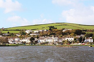
Millbrook is a civil parish and village in southeast Cornwall, England, United Kingdom. The village is situated on the Rame Peninsula four miles (6.5 km) south of Saltash. The population of Millbrook was 2,033 in the 2001 census, increasing to 2,214 at the 2011 census.
Botusfleming or Botus Fleming is a village and civil parish in southeast Cornwall, England, United Kingdom. The 2001 census gives the parish population as 783,which decreased to 771 at the 2011 census. The village is about three miles north-west of Saltash at grid reference SX 403 612. There is a public house, a market garden and a small colony of artists, but the village is mostly a dormitory area for Plymouth.
Bealbury is a hamlet in St Mellion civil parish in east Cornwall, England, United Kingdom. It is two miles south of Callington.
Linkinhorne is a civil parish and village in southeast Cornwall, England, United Kingdom. The village itself is situated at grid reference SX 320 736 and is approximately four miles (6.5 km) northwest of Callington and seven miles (11 km) south of Launceston. The parish population at the 2011 census including Downgate was 1,541

South Hill is a civil parish and hamlet in east Cornwall, England, United Kingdom. The parish population at the 2011 census was 489.

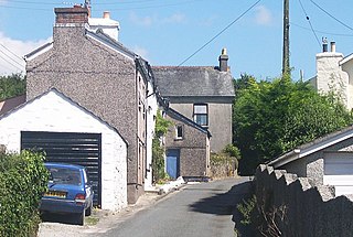
Albaston is a hamlet in Cornwall, England, United Kingdom. It is in the civil parish of Calstock. It is located at Ordnance Survey grid reference SX 423 704.
Landulph is a hamlet and a rural civil parish in south-east Cornwall, England, United Kingdom. It is about 3 miles (5 km) north of Saltash in the St Germans Registration District.
Sheviock is a coastal civil parish and a hamlet in south-east Cornwall, England, United Kingdom. The parish is two miles (3 km) south of St Germans and three miles (5 km) south-west of Saltash.
St John is a coastal civil parish and a village in south-east Cornwall, England, United Kingdom, 3 miles (4.8 km) south of Saltash and 1.5 miles (2.4 km) south-west of Torpoint.

Blunts is a hamlet southeast of Quethiock in the civil parish of Quethiock in east Cornwall, England, United Kingdom. It is situated west of the River Lynher valley about 5 miles (8 km) north-west of Saltash on the road from Quethiock village to Landrake. The meaning of Blunts is "Blunt family's workshop". The hamlet has a Methodist chapel, a garage, and a women's institute.

Luckett is a hamlet in east Cornwall, England. It is situated in a former mining area beside the River Tamar approximately three miles (5 km) north of Callington. According to the Post Office the population at the 2011 census was included in the civil parish of Stokeclimsland

St Dominic is a civil parish and village in Cornwall, England, United Kingdom. The village is situated 2+1⁄2 miles (4.0 km) east of Callington and five miles (8 km) north of Saltash.

Carkeel is a hamlet north of Saltash in southeast Cornwall, England.

Congdon's Shop is a hamlet in the parish of North Hill, Cornwall, England. It is at the junction of the B3254 Launceston to Liskeard road and the B3257 road from Plusha to Callington.

Frogwell is a hamlet in the parish of Callington, Cornwall, England. It is in the valley of the River Lynher.

Insworke is a hamlet in the parish of Millbrook in southeast Cornwall, England, UK. A fair and annual market were held here from 1319.

Kersbrook Cross is a hamlet in the parish of Linkinhorne in Cornwall, England. It is on the B3257 road from Plusha to Callington.
Norris Green is a village in Cornwall, England, UK. It was enlarged from a farming hamlet so that it now adjoins the neighbouring village of Higher Metherell. Both settlements are within the civil parish of Calstock which borders the River Tamar, the county boundary with Devon in south-east Cornwall.

