
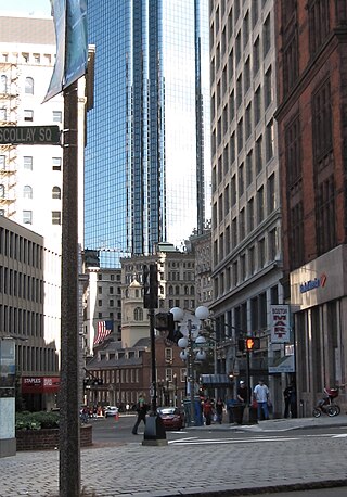
Hawley Street of Boston, Massachusetts, is located in the Financial District between Milk and Summer Streets. Prior to 1799, it was called Bishop's Alley and briefly in the 1790s Board Alley. [1]
Hawley Street of Boston, Massachusetts, is located in the Financial District between Milk and Summer Streets. Prior to 1799, it was called Bishop's Alley and briefly in the 1790s Board Alley. [1]
According to historian Annie Haven Thwing, in 1645 the path that later would become Hawley Street was "laid out through the gardens towards the south windmill, between the houses of Amos Richardson and John Palmer on Summer Street." In the 17th century people referred to it as "'the lane in which the house of Gilbert the tanner stands,' 'a little lane formerly called Gilbert's lane.'" [2]

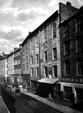
After 1728, the lane was "a path through a pasture made by the worshippers of Trinity Church, who lived in King Street." [3] Because the terrain consisted of a marshy bog, wooden planks were laid down to facilitate travel, and so it was referred to as "Board Alley." [4]
In 1792, theatre enthusiasts organized an illegal theatre, the Board Alley Theatre, also called the "New Exhibition Room." With mixed popular opinion, governor John Hancock shut it down in June 1793. [5] [6]


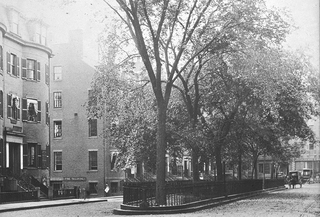
Around the early 19th century, politicians James Sullivan and William Gray lived on the corner of Hawley and Summer Streets. [7] In December 1810, a fire began at Stephen Soper's livery stable, spreading from Hawley to Milk Street, and burning the former home of Benjamin Franklin. [8]
When Melvil Dewey lived in Boston in the 1870s, he served as an officer of the Spelling Reform Association, headquartered at 32 Hawley St. [9]

Post Office Square in Boston, Massachusetts is a square located in the financial district at the intersection of Milk, Congress, Pearl and Water Streets. It was named in 1874 after the United States Post Office and Sub-Treasury which fronted it, now replaced by the John W. McCormack Post Office and Courthouse.
Washington Street is a street originating in downtown Boston, Massachusetts, which extends southwestward to the Massachusetts–Rhode Island state line. The majority of its length outside of the city was built as the Norfolk and Bristol Turnpike in the early 19th century. It is the longest street in Boston and remains one of the longest streets in the Commonwealth of Massachusetts. Due to various municipal annexations with the city of Boston, the name Washington Street now exists 6 or more times within the jurisdiction(s) of the City of Boston.

New Chardon Street is a street in downtown Boston, Massachusetts, United States, north of Government Center. It begins at Cambridge Street at Bowdoin Square, across from Bowdoin Street. The two-way street continues east across Congress Street, ending at Haymarket Square with access to the Sumner and Callahan Tunnels and the Central Artery, as well as local access to Washington Street North and the Surface Artery.

Federal Street is a street in the Financial District of Boston, Massachusetts. Prior to 1788, it was known as Long Lane. The street was renamed after state leaders met there in 1788 to determine Massachusetts' ratification of the United States Constitution.
Court Street is located in the Financial District of Boston, Massachusetts. Prior to 1788, it was called Prison Lane (1634–1708) and then Queen Street (1708–1788). In the 19th century it extended beyond its current length, to Bowdoin Square. In the 1960s most of Court Street was demolished to make way for the construction of Government Center. The remaining street extends a few blocks, near the Old State House on State Street.

Hanover Street is located in the North End of Boston, Massachusetts.

Summer Street in Boston, Massachusetts, extends from Downtown Crossing in the Financial District, over Fort Point Channel, and into the Seaport District to the southeast. In the mid-19th century it was also called Seven Star Lane.

Winter Street in Boston, Massachusetts is located between Tremont Street and Washington Street, near the Common. It is currently a pedestrian zone. Prior to 1708, it was called Blott's Lane and then Bannister's Lane.. It was also known at times as "Winer Street."
Franklin Street is located in the Financial District of Boston, Massachusetts, United States. It was developed at the end of the 18th century by Charles Bulfinch, and included the now-demolished Tontine Crescent and Franklin Place.
Union Street is a street in Government Center, Boston, Massachusetts, near Faneuil Hall. Prior to 1828, it was also called Green Dragon Lane.
The Board Alley Theatre (1792–1793) was an illegal theatre in Boston, Massachusetts in the late 18th century. Also called the New Exhibition Room, it was located in Board Alley in the Financial District. Although some in town supported the theatre, others vehemently opposed it. Governor John Hancock forced it to close in June 1793.

Congress Street in Boston, Massachusetts, is located in the Financial District and South Boston. It was first named in 1800. It was extended in 1854 as far as Atlantic Avenue, and in 1874 across Fort Point Channel into South Boston. Today's Congress Street consists of several segments of streets, previously named Atkinson's Street, Dalton Street, Gray's Alley, Leverett's Lane, Quaker Lane, and Shrimpton's Lane.

Bowdoin Square in Boston, Massachusetts was located in the West End. In the 18th and 19th centuries it featured residential houses, leafy trees, a church, hotel, theatre and other buildings. Among the notables who have lived in the square: physician Thomas Bulfinch; merchant Kirk Boott; and mayor Theodore Lyman. The urban renewal project in the West End in the 1950s removed Green Street and Chardon Street, which formerly ran into the square, and renamed some existing streets; it is now a traffic intersection at Cambridge Street, Bowdoin Street, and New Chardon Street.
North Street in the North End of Boston, Massachusetts extends from Congress Street to Commercial Street. It runs past Dock Square, Faneuil Hall, Quincy Market, the Rose Kennedy Greenway, and North Square. It was first named in 1852, and consists of segments of streets formerly named Ann, Fish, Ship, Drawbridge, and Conduit Streets.

Merchants Row in Boston, Massachusetts, is a short street extending from State Street to Faneuil Hall Square in the Financial District. Since the 17th century, it has been a place of commercial activity. It sits close to Long Wharf and Dock Square, hubs of shipping and trade through the 19th century. Portions of the street were formerly known as Swing-Bridge Lane, Fish Lane, and Roebuck Passage.
Pemberton Square in the Government Center area of Boston, Massachusetts, was developed by P.T. Jackson in the 1830s as an architecturally uniform mixed-use enclave surrounding a small park. In the mid-19th century both private residences and businesses dwelt there. The construction in 1885 of the massive John Adams Courthouse changed the scale and character of the square, as did the Center Plaza building in the 1960s.

The Central Burying Ground is a cemetery in Boston, Massachusetts. It was established on Boston Common in 1756. It is located on Boylston Street between Tremont Street and Charles Street.
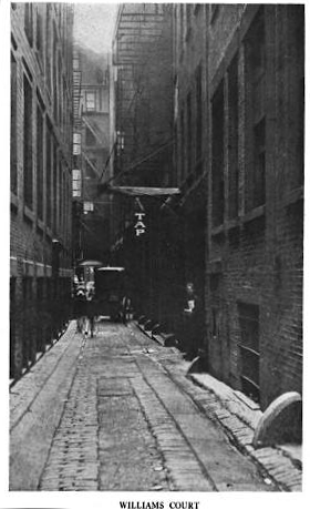
Pi Alley in Boston, Massachusetts is located off Washington Street, near the Old City Hall on School Street. The origin of the short street's name remains in question. It may be named after the pied type which newspaper composing rooms dumped into the alley in the past, or after the local restaurants that sold coffee and a piece of pie for a nickel. It is also known as Williams Court, Savage's Court, Peck's Arch, and Webster's Arch.


Julien's Restorator (1793–1823) was a restaurant in Boston, Massachusetts, established by French-born Jean Baptiste Gilbert Payplat dis Julien. It was one of the first restaurants in Boston; previous public eating-rooms were in "taverns or boarding houses."
42°21′22.31″N71°3′29.74″W / 42.3561972°N 71.0582611°W
