
Warwick is a city in Kent County, Rhode Island, the third largest city in the state with a population of 82,823 at the 2020 census. It is located approximately 12 miles (19 km) south of downtown Providence, Rhode Island, 63 miles (101 km) southwest of Boston, Massachusetts, and 171 miles (275 km) northeast of New York City.

South Kingstown is a town in, and the county seat of, Washington County, Rhode Island, United States. The population was 31,931 at the 2020 census. South Kingstown is the second largest town in Rhode Island by total geographic area, behind New Shoreham, and the third largest town in Rhode Island by geographic land area, behind Exeter and Coventry.

The Pawcatuck River is a river in the US states of Rhode Island and Connecticut flowing approximately 34 miles (55 km). There are eight dams along the river's length. USS Pawcatuck was named after the river.

Kingston is a village and a census-designated place within the town of South Kingstown in Washington County, Rhode Island, United States, and the site of the main campus of the University of Rhode Island. The population was 6,974 at the 2010 census. Much of the village center is listed on the National Register of Historic Places as Kingston Village Historic District. It was originally known as Little Rest.
Chariho is a regional school district located in southern Rhode Island shared by three adjacent towns; Charlestown, Richmond, and Hopkinton. The name Chariho is a portmanteau derived by taking the first two letters from each town name and combining them together. The district operates four elementary schools, two of which are located in Hopkinton, in the villages of Ashaway and Hope Valley, one in Charlestown, and one in Richmond. The Chariho campus located in the Richmond village of Wood River Junction houses the Middle and High Schools, as well as the Chariho Career And Technical Center.
Cowesett is a hillside neighborhood located in Warwick, Rhode Island.

Davisville, Rhode Island is a village in the town of North Kingstown in the U.S. state of Rhode Island that was formerly the home of the Davisville Naval Construction Battalion Center, which housed the United States Navy's SeaBees.

Alton is a small village of about 250 residents within the town of Richmond, Rhode Island. It is located about one hour south of Providence, the state's capital. The village is primarily residential, with no retail stores. Alton is located at a crossing of the Wood River and is 5 miles from the Pawcatuck River.
The Wood River is a river in the U.S. states of Connecticut and Rhode Island. It flows approximately 25 miles (40 km) and is a major tributary of the Pawcatuck River. There are 8 dams along the river's length.
Richmond Airport is a privately owned, public use airport in Washington County, Rhode Island, United States. It is located three nautical miles (6 km) west of the central business district of the village of West Kingston, Rhode Island, in the town of Richmond, Rhode Island.

Kenyon is a small village in the town of Richmond near its border with the town of Charlestown in the U.S. state of Rhode Island.

Usquepaug is a village in the towns of Richmond and South Kingstown in Washington County, Rhode Island, United States. It is located along the Usquepaug River. A portion of the village is listed on the National Register of Historic Places as the Usquepaug Road Historic District.

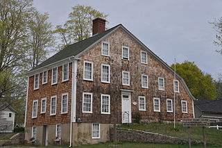
The Tavern Hall Preservation Society is a not-for-profit corporation dedicated to the preservation and upkeep of the Elisha Reynolds House (1738) in Kingston, Rhode Island. The society was founded as the Tavern Hall Club in 1911 to foster understanding and cooperation between the people of the Village of Kingston and the nearby Rhode Island State College community.

Washington County, known locally as South County, is a county located in the U.S. state of Rhode Island. As of the 2020 census, the population was 129,839. Rhode Island counties have no governmental functions other than as court administrative boundaries, which are part of the state government.
Washington is a village within the town of Coventry in Kent County, Rhode Island, and is part of the Pawtuxet River Valley.
South Hopkinton is a small village located in the town of Hopkinton, Rhode Island. Residents of South Hopkinton use the zip code for Bradford, Rhode Island, but the village of Bradford is located only within nearby Westerly.
Centerville and Moscow are two rural adjacent villages in the town of Hopkinton, Rhode Island. Located just outside the village of Hope Valley, the two villages are very small and are only separated by Moscow Pond, a small pond in the Rockville Management Area in the northern section of town. Sometimes referred to as "Centerville-Moscow", the area is located on and around Rhode Island Route 138, known as Spring Street, between the villages of Hope Valley and Rockville.
Woodville is a small village in the towns of Richmond and Hopkinton in the U.S. state of Rhode Island.

Arcadia is a village in the towns of Richmond and Exeter in the U.S. state of Rhode Island.

Barberville is a small village located primarily in the town of Hopkinton, but also extending into Richmond in Washington County, Rhode Island, United States. Barberville is located to the north of Hopkinton's principal village, Hope Valley and uses Hope Valley's zip code, 02832.
