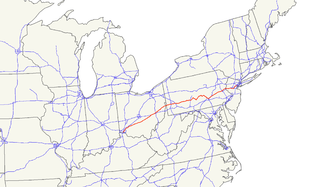
U.S. Route 22 is a west–east route and is one of the original United States highways of 1926, running from Cincinnati, Ohio, at US 27, US 42, US 127, and US 52 to Newark, New Jersey, at U.S. Route 1/9 in the Newark Airport Interchange. US 22 is named the "William Penn Highway" throughout most of Pennsylvania. In southwest Ohio, it overlaps with State Route 3 and is familiarly known as the 3C Highway, "22 and 3", and Montgomery Road.
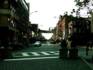
Secaucus is a town in Hudson County, New Jersey, United States. As of the 2010 United States Census, the town's population was 16,264, reflecting an increase of 333 (+2.1%) from the 15,931 counted in the 2000 Census, which had in turn increased by 1,870 (+13.3%) from the 14,061 counted in the 1990 Census.

Lake Hopatcong is the largest freshwater body in New Jersey, United States, about 4 square miles (10 km²) in area. Located 30 miles from the Delaware River and 40 miles from Manhattan, New York City, the lake forms part of the border between Sussex and Morris counties in the state's northern highlands region. Lake Hopatcong was produced by damming and flooding of two ponds, known as the Great Pond and Little Pond, and the Musconetcong River, its natural outlet. Historically known as a resort lake for vacationing New Yorkers, it is now a mostly suburban residential lake.
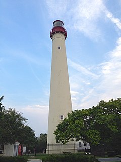
The Cape May Lighthouse is a lighthouse located in the U.S. state of New Jersey at the tip of Cape May, in Lower Township's Cape May Point State Park. It was built in 1859 under the supervision of U.S. Army engineer William F. Raynolds, was automated in 1946, and continues operation to this day. It is the third fully documented lighthouse to be built at Cape May Point. The first was built in 1823; the second in 1847. The exact locations of the first two lighthouses are now underwater due to erosion. There are 199 steps to the top of the Lighthouse. The view from the top extends to Cape May City and Wildwood to the north, Cape May Point to the south, and, on a clear day, Cape Henlopen, Delaware, to the west. Within immediate view are Cape May Cove and Battery 223, a harbor defense battery originally built during World War II. Cape May Lighthouse was added to the National Register of Historic Places on November 12, 1973.

Weehawken Cove is a cove on the west bank of the Hudson River between the New Jersey municipalities of Hoboken to the south and Weehawken to the north. At the perimeter of the cove are completed sections the Hudson River Waterfront Walkway, offering views of Manhattan and the Palisades. The name Weehawken comes from the Lenape, and can translate as "at the end of", either the Hudson Palisades or the stream which flowed from them into the cove, later the site of the nearby Lincoln Tunnel.

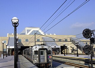
The Bergen County Line is a commuter rail line and service owned and operated by New Jersey Transit in the U.S. state of New Jersey. The line loops off the Main Line between the Meadowlands and Glen Rock, with trains continuing in either direction along the Main Line. It is colored on NJT system maps in pale blue, and its symbol is a cattail.

Edward Parker Helms is an American actor, comedian, and singer. He is known for his work as a correspondent on The Daily Show as well as playing Andy Bernard in the U.S. version of The Office, and Stuart Price in The Hangover trilogy. He also provided the voice of Captain Underpants in Dreamworks Animation's Captain Underpants: The First Epic Movie.
Glen Cove or Glencove may refer to:
Lane Cove Rugby Union Football Club is a rugby union club founded in 1949 and which participates in the New South Wales Suburban Rugby Union ("Subbies") competition. The club is situated in Lane Cove in Sydney, Australia. The home ground is Tantallon Oval. The club was successful in Sydney Rugby through the 1950s and 1960s and competitive in Division One Sub-Districts into the 1980s with victories including the Under 21 New South Wales State Premiership, the Bruce Graham Shield, Kentwell Cup, Whiddon Cup, Judd Cup trophies among others. Notable players have included Wallaby Ken Yanz. Having been historically a Division One Club, Lane Cove seniors currently plays in New South Wales' Subbies' Division Five, while the thriving Lane Cove Juniors participate in the Gordon Juniors competition.

George Helm Yeaman was a U.S. Representative from Kentucky.

The Cove Point Light is a lighthouse located on the west side of Chesapeake Bay in Calvert County, Maryland.

The Hudson and Manhattan Railroad Powerhouse, also known as the Jersey City Powerhouse in Jersey City, Hudson County, New Jersey, United States, was built in 1908. The powerhouse made possible the subway system between New Jersey and New York for the Hudson and Manhattan Railroad. The powerhouse was closed in 1929 and used as a storage place for railroad equipment. In the 1990s, the building was cited by Preservation New Jersey as one of the state's ten most endangered historic sites. The powerhouse was added to the National Register of Historic Places on November 23, 2001. It is located near the Harborside Financial Center and Harsimus Cove on the Hudson River waterfront in an area undergoing much redevelopment. Efforts to stabilize the powerhouse from further deterioration began July 2009 and continued through 2010. In 2011 the Port Authority of New York and New Jersey agreed to transfer its 55% ownership of the building to its co-owner, Jersey City, in exchange for a nearby lot where they will build an underground electric sub-station. It was determined that the iconic smokestacks could not be saved and they have been removed.
Harsimus is a neighborhood within Downtown Jersey City, Hudson County, New Jersey, United States. The neighborhood stretches from the Harsimus Stem Embankment on the north to Christopher Columbus Drive on the south between Coles Street and Grove Street or more broadly, to Marin Boulevard. It borders the neighborhoods of Hamilton Park to the north, Van Vorst Park to the south, the Village to the west, and the Powerhouse Arts District to the east. Newark Avenue has traditionally been its main street. The name is from the Lenape, used by the Hackensack Indians who inhabited the region and could be translated as Crow’s Marsh. From many years, the neighborhood was part of the "Horseshoe", a political delineation created by its position between the converging rail lines and political gerrymandering.

Hamilton Park is a neighborhood in Historic Downtown Jersey City, Hudson County, New Jersey, United States, centered on a park with the same name. Hamilton Park is located west of Newport, north of Harsimus Cove, north and east of The Village and south of Boyle Plaza. The Victorian age park is located between Eighth Street and Ninth Street and Hamilton Place on the west and McWilliams Place on the East. Like the Van Vorst Park neighborhood to the south, this quiet park is surrounded by nineteenth century brownstones. The park underwent renovations completed in 2010.
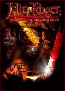
Jolly Roger: Massacre at Cutter's Cove is a 2005 American horror film by The Asylum, written by Gary Jones and Jeffrey Miller and directed by Jones, and starring Rhett Giles as Jolly Roger.
Aenid was a wooden cutter belonging to Commodore William Wiseman, the commanding officer of the Australia Station. The vessel was wrecked at Long Reef, New South Wales, Australia. on 13 November 1865, whilst carrying cargo between Sydney and Broken Bay.
The Federalists ran a mixed ticket consisting of 2 Federalists and 4 Democratic-Republicans, one of whom was also on the Democratic-Republican ticket. The Federalists capitalized on resentment over the replacement on the official Democratic-Republican ticket of Ebenezer Elmer, from South Jersey, with Thomas Newbold from Monmouth County and the retention of James Sloan. This ticket was formed too late to gain sufficient support, but the Federalists did do much better in state elections that year than they had in previous elections.

Harmon Cove is an abandoned train station in the Harmon Cove section of Secaucus, New Jersey. The station was a former stop on the Bergen County Line which runs from Hoboken Terminal to Suffern. Train service was discontinued in 2003 when Secaucus Junction was opened.

Welwyn Preserve County Park is a 204-acre (0.83 km2) public nature reserve in Glen Cove, on the North Shore of Long Island in New York State.
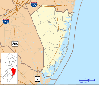
Glen Cove is an unincorporated community located within Berkeley Township, in Ocean County, New Jersey, United States.


