Salem County is a county located in the U.S. state of New Jersey. Its western boundary is formed by the Delaware River and it has the eastern terminus of the Delaware Memorial Bridge, connecting to New Castle, Delaware. Its county seat is Salem. The county is part of the Delaware Valley area. As of the 2020 United States Census, the county's population was enumerated to be 64,837, retaining its position as the state's least populous county, representing a 1.9% decrease from the 66,083 counted at the 2010 U.S. Census, in turn increasing by 1,798 (+2.8%) from the 64,285 counted in the 2000 Census. The most populous place in Salem County is Pennsville Township, with 13,409 residents at the time of the 2010 Census. Lower Alloways Creek Township covers 72.46 square miles (187.7 km2), the largest total area of any municipality.
Route 45 is a state highway in the southern part of New Jersey, United States. It runs 28.51 mi (45.88 km) from Route 49 in Salem, Salem County, northeast to U.S. Route 130 in Westville, Gloucester County. Much of the southern part of the route runs through rural areas of Salem and Gloucester counties, passing through the communities of Woodstown and Mullica Hill. North of Mullica Hill, Route 45 runs through suburban areas, with the portion of the route between the northern border of Mantua Township and the southern border of Woodbury a four-lane divided highway. The route intersects many highways, including US 40 in Woodstown, Route 77 and US 322 in Mullica Hill, and Interstate 295 (I-295) in West Deptford Township.
Route 49 is a state highway in the southern part of the U.S. state of New Jersey. It runs 53.80 mi (86.58 km) from an interchange with the New Jersey Turnpike, Interstate 295 (I-295), and U.S. Route 40 (US 40) in Deepwater, Salem County, southeast to Route 50 and County Route 557 in Tuckahoe, Cape May County. The route serves Salem, Cumberland, Atlantic, and Cape May Counties, passing through rural areas and the communities of Salem, Bridgeton, and Millville along the way. It is a two-lane, undivided road for most of its length.

Oakland is a borough in Bergen County, New Jersey, United States and a suburb of New York City. As of the 2010 United States Census, the borough's population was 12,754, reflecting an increase of 288 (+2.3%) from the 12,466 counted in the 2000 Census, which had in turn increased by 469 (+3.9%) from the 11,997 counted in the 1990 Census.

Alloway Township is a township in Salem County, New Jersey, United States. As of the 2010 United States Census, the township's population was 3,467, reflecting an increase of 693 (+25.0%) from the 2,774 counted in the 2000 Census, which had in turn declined by 21 (-0.8%) from the 2,795 counted in the 1990 Census. What is now Alloway was formally incorporated as Upper Alloways Creek Township by a Royal charter granted on June 17, 1767, from portions of the now-defunct Alloways Creek Township. The township was formally incorporated by an act of the New Jersey Legislature on February 21, 1798. Quinton Township was formed from portions of the township on February 18, 1873. The name was officially changed to Alloway Township as of February 21, 1884.

Elsinboro Township is a township in Salem County, New Jersey, United States. As of the 2010 United States Census, the township's population was 1,036, reflecting a decline of 56 (-5.1%) from the 1,092 counted in the 2000 Census, which had in turn declined by 78 (-6.7%) from the 1,170 counted in the 1990 Census.

Mannington Township is a township in Salem County, New Jersey, United States. As of the 2010 United States Census, the township's population was 1,806, reflecting an increase of 247 (+15.8%) from the 1,559 counted in the 2000 Census, which had in turn declined by 134 (-7.9%) from the 1,693 counted in the 1990 Census.

Salem is a city in Salem County, in the U.S. state of New Jersey. As of the 2010 United States Census, the city's population was 5,146, reflecting a decrease of 711 (−12.1%) from the 5,857 counted in the 2000 Census, which had in turn declined by 1,026 (−14.9%) from the 6,883 counted in the 1990 Census, an overall drop of more than 25% over the two decades. It is the county seat of Salem County, the state's most rural county. The name "Salem", in both the city and county, is derived from the Hebrew word shalom, meaning "peace".

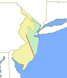
West Jersey and East Jersey were two distinct parts of the Province of New Jersey. The political division existed for 28 years, between 1674 and 1702. Determination of an exact location for a border between West Jersey and East Jersey was often a matter of dispute.
U.S. Route 202 (US 202) is a spur route of US 2. It follows a northeasterly and southwesterly direction stretching from Delaware to Maine, also traveling through the states of Pennsylvania, New Jersey, New York, Connecticut, Massachusetts, and New Hampshire. The highway has borne the number 202 since at least 1936. Before this, sections of the highway were designated U.S. Route 122, as it intersected US 22. Its current designation is based on its intersection with US 2 in Maine.

South Jersey comprises the southern portion of the U.S. state of New Jersey, between the lower Delaware River and the Atlantic Ocean. The designation of southern New Jersey with a distinct toponym is a colloquial one rather than an administrative one, reflecting not only geographical but also perceived cultural differences from the northern part of the state, with no official definition. Though definitions of South Jersey may vary, most of South Jersey is generally considered to be part of the Philadelphia Metropolitan Area.

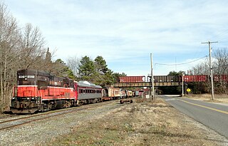
The Southern Railroad of New Jersey is a small short-line railroad company based in Winslow Township, New Jersey. The railroad operates freight trains in two areas in Southern New Jersey. In the Winslow area, trains operate between Winslow Junction and Pleasantville, and between Winslow Junction and the Winslow Hot Mix asphalt plant in Winslow Township. In Salem County and Gloucester County, the company operates on the Salem Branch between Salem and Woodbury.
Salem High School is a comprehensive community four-year public high school that serves students in ninth through twelfth grades from Salem City, in Salem County, New Jersey, United States, as part of the Salem City School District. Students from Elsinboro Township, Lower Alloways Creek Township, Mannington Township and Quinton Township attend the school as part of sending/receiving relationships with the respective districts.
Oakland is a city in California, United States.
A tenth was used to divide the former American Province of West Jersey into smaller administrative divisions. Despite seemingly related names, tenths are not directly related to hundreds, other than both being administrative divisions.

Aldine is an unincorporated community located within Alloway Township in Salem County, New Jersey, United States. It is located at the crossroads of Salem County Routes 611 and 635. The village includes several houses, farms and the Aldine United Methodist Church, which was built in 1868, and underwent many renovations. The church has an Elmer mailing address, but is located in the Aldine section of Alloway Township.

Penton is an unincorporated community located within Alloway Township in Salem County, New Jersey, United States. The community is the site of the historic Penton Chapel.

Riddleton is an unincorporated community located within Alloway Township in Salem County, New Jersey, United States.


