Riddleton, New Jersey

Last updated
Riddleton, New Jersey
Unincorporated community
Location map of Salem County, New Jersey.svg
Red pog.svg
Riddleton, New Jersey
Riddleton's location in Salem County (Inset: Salem County in New Jersey)
USA New Jersey location map.svg
Red pog.svg
Riddleton, New Jersey
Riddleton, New Jersey (New Jersey)
Usa edcp location map.svg
Red pog.svg
Riddleton, New Jersey
Riddleton, New Jersey (the US)
Coordinates: 39°35′40″N75°21′10″W / 39.59444°N 75.35278°W / 39.59444; -75.35278 Coordinates: 39°35′40″N75°21′10″W / 39.59444°N 75.35278°W / 39.59444; -75.35278
Country Flag of the United States.svg  United States
State Flag of New Jersey.svg  New Jersey
County Salem
Township Alloway
Elevation 12 m (39 ft)
Time zone Eastern (EST) (UTC-5)
  Summer (DST) EDT (UTC-4)
GNIS feature ID 882970 [1]

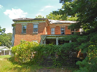
Riddleton is an unincorporated community located within Alloway Township in Salem County, New Jersey, United States. [2]

Alloway Township, New Jersey Township in New Jersey

Alloway Township is a township in Salem County, New Jersey, United States. As of the 2010 United States Census, the township's population was 3,467, reflecting an increase of 693 (+25.0%) from the 2,774 counted in the 2000 Census, which had in turn declined by 21 (-0.8%) from the 2,795 counted in the 1990 Census. What is now Alloway was formally incorporated as Upper Alloways Creek Township by a Royal charter granted on June 17, 1767, from portions of the now-defunct Alloways Creek Township. The township was formally incorporated by an act of the New Jersey Legislature on February 21, 1798. Quinton Township was formed from portions of the township on February 18, 1873. The name was officially changed to Alloway Township as of February 21, 1884.

Salem County, New Jersey county in New Jersey, United States

Salem County is a county located in the U.S. state of New Jersey. Its western boundary is formed by the Delaware River and it has the eastern terminus of the Delaware Memorial Bridge, connecting to New Castle, Delaware. Its county seat is Salem. The county is part of the Delaware Valley area. As of the 2017 Census estimate, the county's population was 62,792, making it the state's least populous county, representing a 5.0% decrease from the 66,083 enumerated at the 2010 Census, in turn increasing by 1,798 (+2.8%) from the 64,285 counted in the 2000 Census, retaining its position as the state's least populous county. The most populous place was Pennsville Township, with 13,409 residents at the time of the 2010 Census. Lower Alloways Creek Township covers 72.46 square miles (187.7 km2), the largest total area of any municipality.

New Jersey State of the United States of America

New Jersey is a state in the Mid-Atlantic region of the Northeastern United States. It is a peninsula, bordered on the north and east by the state of New York, particularly along the extent of the length of New York City on its western edge; on the east, southeast, and south by the Atlantic Ocean; on the west by the Delaware River and Pennsylvania; and on the southwest by the Delaware Bay and Delaware. New Jersey is the fourth-smallest state by area but the 11th-most populous, with 9 million residents as of 2017, and the most densely populated of the 50 U.S. states; its biggest city is Newark. New Jersey lies completely within the combined statistical areas of New York City and Philadelphia and was the second-wealthiest U.S. state by median household income as of 2017.

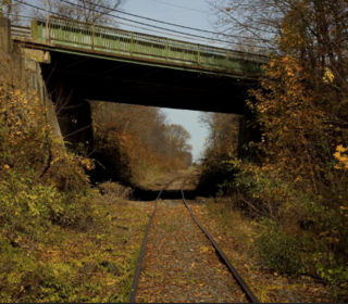
The vicinity used to have a stop on the West Jersey and Seashore Railroad. [3]

West Jersey and Seashore Railroad

The West Jersey and Seashore Railroad (WJ&S) was a Pennsylvania Railroad subsidiary that became part of Pennsylvania-Reading Seashore Lines in 1933. At the end of 1925 it operated 379 miles (610 km) of road on 717 miles (1,154 km) of track; that year it reported 166 million ton-miles of revenue freight and 332 million passenger-miles.

Related Research Articles

New Jersey Route 45 highway in New Jersey

Route 45 is a state highway in the southern part of New Jersey, United States. It runs 28.51 mi (45.88 km) from Route 49 in Salem, Salem County, northeast to U.S. Route 130 in Westville, Gloucester County. Much of the southern part of the route runs through rural areas of Salem and Gloucester counties, passing through the communities of Woodstown and Mullica Hill. North of Mullica Hill, Route 45 runs through suburban areas, with the portion of the route between the northern border of Mantua Township and the southern border of Woodbury a four-lane divided highway. The route intersects many highways, including US 40 in Woodstown, Route 77 and US 322 in Mullica Hill, and Interstate 295 (I-295) in West Deptford Township.

Elsinboro Township, New Jersey Township in New Jersey

Elsinboro Township is a township in Salem County, New Jersey, United States. As of the 2010 United States Census, the township's population was 1,036, reflecting a decline of 56 (-5.1%) from the 1,092 counted in the 2000 Census, which had in turn declined by 78 (-6.7%) from the 1,170 counted in the 1990 Census.

Pennsville Township, New Jersey Township in New Jersey, United States

Pennsville Township is a township in Salem County, in the U.S. state of New Jersey. As of the 2010 United States Census, the township's population was 13,409, reflecting an increase of 215 (+1.6%) from the 13,194 counted in the 2000 Census, which had in turn declined by 600 (-4.3%) from the 13,794 counted in the 1990 Census. The township is named for William Penn. The township includes the state's westernmost point.

Pilesgrove Township, New Jersey Township in New Jersey, United States

Pilesgrove Township is a township in Salem County, New Jersey, United States. As of the 2010 United States Census, the township's population was 4,016, reflecting an increase of 93 (+2.4%) from the 3,923 counted in the 2000 Census, which had in turn increased by 673 (+20.7%) from the 3,250 counted in the 1990 Census.

Pittsgrove Township, New Jersey Township in New Jersey, United States

Pittsgrove Township is a township in Salem County, in the U.S. state of New Jersey. As of the 2010 United States Census, the township's population was 9,393, reflecting an increase of 500 (+5.6%) from the 8,893 counted in the 2000 Census, which had in turn increased by 772 (+9.5%) from the 8,121 counted in the 1990 Census.

Salem, New Jersey City in New Jersey, United States

Salem is a city in Salem County, in the U.S. state of New Jersey. As of the 2010 United States Census, the city's population was 5,146, reflecting a decrease of 711 (−12.1%) from the 5,857 counted in the 2000 Census, which had in turn declined by 1,026 (−14.9%) from the 6,883 counted in the 1990 Census, an overall drop of more than 25% over the two decades. It is the county seat of Salem County, the state's most rural county. The name "Salem", in both the city and county, is derived from the Hebrew word shalom, meaning "peace".

A tenth was a geographic division used in the former American Province of West Jersey, to divide a larger region into smaller administrative divisions. Despite seemingly related names, tenths are not directly related to hundreds, other than both being administrative divisions.

Salem Branch

The Salem Branch is a rail freight line in the southwestern part of New Jersey in the United States between the Port of Salem and Woodbury Junction where it and the Penns Grove Secondary converge with the Vineland Secondary approximately 8.5 miles (13.7 km) south of Pavonia Yard in Camden.

Aldine, New Jersey Unincorporated community in New Jersey, United States

Aldine is an unincorporated community located within Alloway Township in Salem County, New Jersey, United States. It is located at the crossroads of Salem County Routes 611 and 635. The village includes several houses, farms and the Aldine United Methodist Church, which was built in 1868, and underwent many renovations. The church has an Elmer mailing address, but is located in the Aldine section of Alloway Township.

Friesburg, New Jersey Unincorporated community in New Jersey, United States

Friesburg is an unincorporated community located within Alloway Township, in Salem County, New Jersey, United States. It was founded in 1748 and previously contained a post office, creamery, general store, sawmill, and blacksmith.

Penton, New Jersey Unincorporated community in New Jersey, United States

Penton is an unincorporated community located within Alloway Township in Salem County, New Jersey, United States. The community is the site of the historic Penton Chapel.

Alloway Junction, New Jersey Unincorporated community in New Jersey, United States

Alloway Junction is an unincorporated community located within Alloway Township in Salem County, New Jersey, United States.

Remsterville, New Jersey Unincorporated community in New Jersey, United States

Remsterville is an unincorporated community located within Alloway Township in Salem County, New Jersey, United States.

Oakland, Salem County, New Jersey Unincorporated community in New Jersey, United States

Oakland is an unincorporated community located within Alloway Township in Salem County, New Jersey, United States.

References