Hmar is a Kuki ethnic group living in Northeast Indian state of Manipur, Mizoram, Assam and western Myanmar (Burma) and eastern Bangladesh. They use Meitei language as their second language (L2) in Manipur. They speak Mizo language as their L1 in Mizoram.
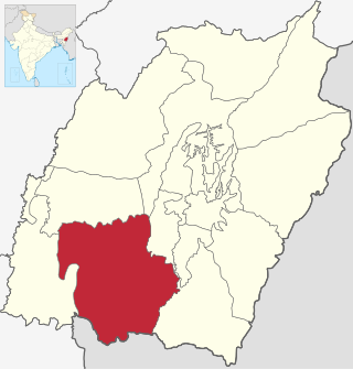
Churachandpur District, is one of the 16 districts of the Indian state of Manipur populated mainly by Kuki-Zo people. The name honours former Maharaja Sir Churachand Singh of Manipur. The district headquarters is located in the Churachandpur town, which is also locally known by the name Lamka.
The Paite people are an ethnic group in Northeast India, mainly living in Manipur and Mizoram. The Paites are recognized as a scheduled tribe in these two states. They are part of the Kuki-Zo people, "Guite" is a major clan of the Paite people.

The Kuki people are an ethnic group in the Northeastern Indian states of Manipur, Nagaland, Assam, Meghalaya, Tripura and Mizoram, as well as the neighbouring countries of Bangladesh and Myanmar. The Kuki constitute one of several hill tribes within India, Bangladesh, and Myanmar. In Northeast India, they are present in all states except Arunachal Pradesh.

Bishnupur district or Bishenpur district, is a district of Manipur state in northeastern India.

Thoubal district is one of the sixteen districts of Manipur state in northeastern India. This district is bounded by Senapati district on the north, Ukhrul and Chandel districts on the east, Churchandpur and Bishnupur districts on the south and Imphal West and Imphal East districts on the west. The district occupies an area of 324 km2. The population as of 2011 is 286,687. Thoubal town is the district headquarters. This district is known for Khongjom, where the last battle of the independence of Manipur was fought in April 1891 against the British army.

Ukhrul district is an administrative district of the state of Manipur in India with its headquarters at Ukhrul. The Ukhrul district has a long history dating back to the 1920s when it was created as the North-East Hill Sub-Division of the then princely state of Manipur. In 2016, the Kamjong subdivision of the Ukhrul district was spun out as a separate district, leading to the present configuration of the Ukhrul district.
Sugnu is a small town at the southern tip of the Kakching district in Manipur, India. It is on the bank of the Manipur River, to the east of Churachandpur district, Chandel district to the east and Bishnupur district.
Tipaimukh Sub-Division is located in south-western hilly region of Manipur bordering the Indian state of Mizoram. It is one of the six tribal development blocks of Churachandpur district in Manipur state. Parbung is the sub-divisional block headquarters. The total geographic area of the sub-division block is 789.48 km², having 55 villages with the total population of 23,995 approx. The total number of voters is 18,848. The total distance from the Parbung to the district headquarters town of Churachandpur is 247 km through the Tipaimukh Road, also known as NH 150.
Hiangtam is a village located within Churachandpur district of Manipur, India.
Churachandpur, locally known as Lamka, is the second largest town in the Indian state of Manipur and the district headquarters of the Churachandpur District. The name "Churachandpur" was transferred from the earlier headquarters of the district at Songpi to the present location, and honours Churachand Singh, former maharaja of the Manipur princely state. The local people reject the name as a colonial imposition and use the native name "Lamka".
The Mate people are one of the Kuki tribes of Manipur, India. The Mates – a name, in its literal sense, connotes front beaters and consequently, in the broadest sense as a designation, implies a migratory people – are a little-known tribal community of Manipur, India, whose socio-cultural identity as a distinct tribe was only recently recognised by the Union Government of India and the State Government of Manipur. The Mates achieved recognition as a scheduled tribe in January 2012.
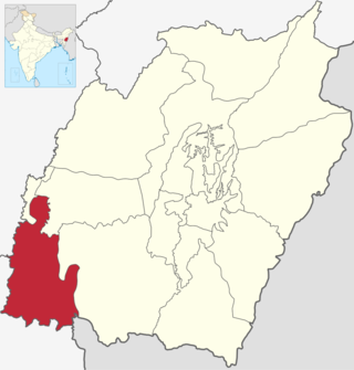
Pherzawl district is a district of Manipur state in India and the district is mainly populated by Kuki-Zo

Tengnoupal district is a district in Manipur, India. It was created in December 2016 by splitting the Chandel district.
Khuga River, also known as the Tuitha River, is a river in Manipur, India. It originates in the Churachandpur district and flows through the district for much of its course. It enters the Imphal Valley near Torbung, and flows east, joining the Manipur River near Ithai. The Khuga River valley in the Churachandpur district is thickly populated, with the Churachandpur town and numerous villages.
Thangjing Hill , is a mountain peak in the Indian state of Manipur. It is in the Churachandpur district, to the west of Moirang. The north-south-running mountain range on which it sits is also called Thangjing range or Thangjing Hills. The range forms part of the western border of the Imphal Valley.
On 3 May 2023, ethnic violence erupted in India's north-eastern state of Manipur between the Meitei people, a majority that lives in the Imphal Valley, and the Kuki-Zo tribal community from the surrounding hills. According to government figures, as of 15 September, 175 people have been killed in the violence. 1,108 others were injured while 32 are missing. 4,786 houses were burnt and 386 religious structures including temples and churches were vandalized. The violence left more than 70,000 people displaced from their homes. Unofficial figures are higher.
Mombi, original name Lawmpi or Lonpi, is a census village in the Chandel district in the Manipur state of India. It had a population of 464 in the 2011 census.
Torbung is a census village split across the Bishnupur district and Churachandpur district in Manipur, India. The Bishnupur part of the village has a population of 2781, and the Churachandpur part a population of 1047 in the 2011 census. Torbung is on the bank of the Torbung river, which flows down from Thangjing hills to join the Khuga River. It is a village of historical as well as current political significance.


