
Amargosa Valley is an unincorporated town located on U.S. Route 95 in Nye County, in the U.S. state of Nevada.

Daggett is an unincorporated community located in San Bernardino County, California in the United States. The town is located on Interstate 40 ten miles (16 km) east of Barstow. The town has a population of about 200. The ZIP code is 92327 and the community is inside area code 760.

Death Valley Junction, also known as Amargosa, is a tiny Mojave Desert unincorporated community in Inyo County, California, at the intersection of SR 190 and SR 127, in the Amargosa Valley and just east of Death Valley National Park. The zip code is 92328, the elevation is 2,041 ft (622 m), and the population is fewer than 4.
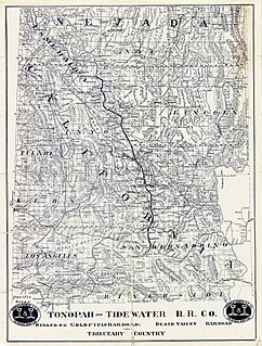
The Tonopah and Tidewater Railroad was a former class II railroad that served eastern California and southwestern Nevada.
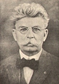
Francis Marion Smith was an American miner, business magnate and civic builder in the Mojave Desert, the San Francisco Bay Area, and Oakland, California.
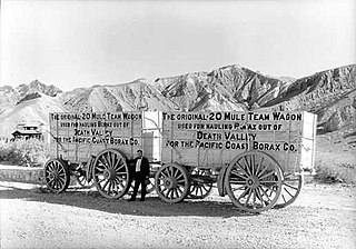
The Pacific Coast Borax Company (PCB) was a United States mining company founded in 1890 by the American borax magnate Francis "Borax" Smith, the "Borax King".

The Death Valley Railroad (DVRR) was a 3 ft narrow gauge railroad that operated in California's Death Valley to carry borax with the route running from Ryan, California and the mines at Lila C, both located just east of Death Valley National Park, to Death Valley Junction, a distance of approximately 20 miles (32 km).

The Amargosa Desert is located in Nye County in western Nevada, United States, along the California–Nevada border, comprising the northeastern portion of the geographic Amargosa Valley, north of the Ash Meadows National Wildlife Refuge

State Route 127 is a state highway in the U.S. state of California that connects Interstate 15 in Baker to Nevada State Route 373 at the Nevada state line, passing near the eastern boundary of Death Valley National Park. The entire length of the highway closely follows the central portion of the former Tonopah and Tidewater Railroad and loosely follows the Amargosa River.
The Santa Maria Valley Railroad is a 14.8 miles (23.8 km) shortline railroad that interchanges with the Union Pacific Railroad's Coast Line at Guadalupe, California. As of 2006, the Railroad is owned by the Coast Belle Rail Corporation.
Castaic Junction is an unincorporated community located in Los Angeles County, California. It is located at the crossroads of Interstate 5 and State Route 126 at the Santa Clara River.
The Hahn Company, San Diego, California, alternately known as Ernest W. Hahn, Inc., was a major American shopping center owner and developer from the 1950s to the 1980s. Purchased by the Trizec Corp. in 1980, it became defunct.
U.S. Route 395 (US 395) is a United States Numbered Highway, stretching from Hesperia, California to the Canadian border in Laurier, Washington. The California portion of US 395 is a 557-mile (896 km) route which traverses from Interstate 15 (I-15) in Hesperia, north to the Oregon state line in Modoc County near Goose Lake. The route clips into Nevada, serving the cities Carson City and Reno, before returning to California.
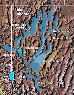
The Lahontan Valley is a basin in Churchill County, Nevada, United States. The valley is a landform of the central portion of the prehistoric Lake Lahontan's lakebed of 20,000-9,000 years ago. The valley and the adjacent Carson Sink represent a small portion of the lake bed. Humboldt Lake is to the valley's northeast. Pyramid Lake is west. Walker Lake is to the south.

Lila C is a former settlement in Inyo County, California. It was located 6.25 miles (10 km) southwest of Death Valley Junction, at an elevation of 2562 feet.

Ryan is an unincorporated community in Inyo County, California. A former mining community and company town, Ryan is situated at an elevation of 3,045 feet (928 m) in the Amargosa Range, 8 miles (13 km) northeast of Dante's View and 15 miles (24 km) southeast of Furnace Creek.
Schellville is an unincorporated community in Sonoma County, California, United States. Schellville is located in the vicinity of the junction of California State Route 12 and California State Route 121 south of Sonoma. The community had a post office from 1888 to 1931.

Amargosa Opera House and Hotel is a historic building and cultural center located in Death Valley Junction, in eastern Inyo County, California near Death Valley National Park. Resident artist Marta Becket staged dance and mime shows there from the late 1960s until her final show in February 2012. The Death Valley Junction Historic District is on the National Register of Historic Places and is owned by the nonprofit established by Becket for the preservation of the property.

Rocktram is an unincorporated community in Napa County, California. It lies at an elevation of 13 feet. Rocktram is located on the Southern Pacific Railroad, 3 miles (4.8 km) south of Napa, at the junction with the Napa Valley Railroad and the Basalt Rock Company rock tram. This area got its name from an overhead tramway between the Basalt Rock Company quarry and a plant located on the Napa River. The tram crossed California State Route 221 near what is now Kaiser Road. Metal containers that hung from a steel cable transported rock from Basalt's quarry on the hills east of the highway to the plant on the river. The rocks were loaded on barges and floated down to construction sites from Sacramento to San Francisco. Rocks from Basalt were used in the construction of Treasure Island and most of the Bay Area bridges.
The California Central Railway was incorporated on April 23, 1887, with headquarters in San Bernardino, California. George O. Manchester was the President of the corporation.
