
Middleton is a town in Essex County, Massachusetts, United States. The population was 9,779 at the 2020 census.

Boxford is a town in Essex County, Massachusetts, United States. According to the U.S. Census Bureau, the town's population was 8,203 in 2020.

Greenwood Farm is a historic property and nature reserve located in Ipswich, Massachusetts, and owned by The Trustees of Reservations. The farm is 216 acres of gardens, pastures, meadows, woodlands and salt marsh and it features the PaineHouse, a First Period farmhouse constructed in 1694.

The Cady-Copp House is an historic house at 115 Liberty Highway in Putnam, Connecticut. Built about 1745 and little altered since, it is an important regional example of vernacular colonial architecture. It was listed on the National Register of Historic Places in 2001.
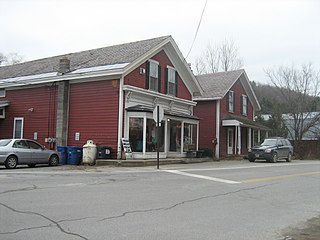
The South Coventry Historic District is a historic district encompassing the historic village center of South Coventry in the town of Coventry, Connecticut. The village, settled in the early 18th century, has served as Coventry's civic center, and also served as an economic center, with textile mills operating in the 19th century. The district was listed on the National Register of Historic Places in 1991.

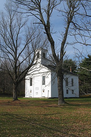
The Old Centre Historic District is a historic district encompassing the historic town center of Winchendon, Massachusetts. It includes the town's first cemetery, the First Congregational Church, and the oldest surviving house in town, and only one building constructed after 1850. The district was added to the National Register of Historic Places in 1987.

Hortonville is a village in the town of Swansea, Bristol County, Massachusetts, United States. The part of the village on Locust Street from Oak Street to Hortonville Road comprises the Hortonville Historic District, which was listed on the National Register of Historic Places in 1990.

The Bigelow Tavern Historic District is a historic district in West Boylston, Massachusetts. It consists of a cluster of three buildings: Bigelow Tavern, the White/Gibbs Store, and Temple's Distillery. The buildings have a history of common ownership, and the area was locally important from the late 18th century into the late 19th century. The district was added to the National Register of Historic Places in 1992.

The South Lee Historic District encompasses the historic portion of the village of South Lee in Lee, Massachusetts. Extending mainly along Massachusetts Route 102 between Fairview Street and the Stockbridge town line, the village is a well-preserved 19th-century mill village, with fine Federal and Greek Revival buildings and a later 19th-century paper mill. It was listed on the National Register of Historic Places in 1999.

The Conway Center Historic District encompasses the historic village center of Conway, Massachusetts. The district is focused on Main Street, a section of Massachusetts Route 116 that connects two major road intersections on either side of the South River. It includes properties on Main Street, Elm Street, and Academy Hill Road, and is generally representative of the growth of the community between about 1830 and 1930. The district was listed on the National Register of Historic Places in 1999.
The Ware Center Historic District encompasses the historic early center of Ware, Massachusetts. Centered at the junction of Massachusetts Route 9 with Greenwich Plains Road, it is a linear district extending about 0.5 miles (0.80 km) along Route 9 in either direction. Most of the structures in the district were built between 1760 and 1860, although there are some 20th century intrusions. The area was the center of town civic and commercial activity until the 1820s, when villages serving industry became more important. The district was listed on the National Register of Historic Places in 1986.
The North Chester Historic District is a historic district encompassing the rural village center of North Chester in the town of Chester, Massachusetts. One of the rural community's early settlement nodes, it thrived into the early 19th century around a stagecoach tavern, a few small mills, and farming, and retains buildings and archaeological remains representative of this history. The district was listed on the National Register of Historic Places in 1998.
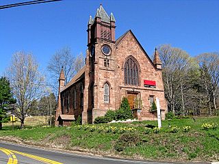
The Boxford Village Historic District encompasses the historic early center of Boxford, Massachusetts, which was established in 1638 and incorporated in 1685. The district runs from near Towne Road in the west, along Main Street and Topsfield Road to Dana Road, and includes sections of Middleton Road, Elm Street, Depot Road and Cross Street. It includes a remarkable concentration of structures dating to no later than the late 18th century. The district was listed on the National Register of Historic Places in 1973. It includes the Holyoke-French House, a First Period house owned by the Boxford Historical Society and operated as a house museum.
The Bacon–Morse Historic District encompasses a historic rural village center in Southbridge, Massachusetts. It consists of a collection of houses and barns, as well as a cemetery, at the intersection of North Woodstock and Tipton Rock Roads. Its name comes from the early settlers of the area, who included families named Morse and Bacon. The area once also included a tavern and a schoolhouse, but these were demolished some years ago. The district was listed on the National Register of Historic Places in 1989.

The Main Street Historic District encompasses the historic civic, commercial, and residential center of Durham, Connecticut. The district is primarily linear and runs along Main Street from between Higganum Road and Town House Road in the south to Talcott Lane in the north, and along Maple Avenue, which parallels Main Street. The district includes most of its colonial architecture, as well as many of its civic buildings. It was listed on the National Register of Historic Places in 1986.
The Northford Center Historic District encompasses the historic village area of Northford in northern North Branford, Connecticut. The basically linear district extends along Middletown Avenue from the village center at its southern end, to a point beyond its northern junction with Old Post Road. The area was settled in the early 18th century, and was transformed into a rural industrial village in the 19th century by the locally prominent Maltby and Fowler families. The district includes many fine pre-Civil-War houses, two churches, and a schoolhouse. It was listed on the National Register of Historic Places in 2002.

The Amherst Village Historic District encompasses the historic village center of Amherst, New Hampshire. Centered on the town's common, which was established about 1755, Amherst Village is one of the best examples of a late-18th to early-19th century New England village center. It is roughly bounded on the north by Foundry Street and on the south by Amherst Street, although it extends along some roads beyond both. The western boundary is roughly Davis Lane, the eastern is Mack Hill Road, Old Manchester Road, and Court House Road. The district includes the Congregational Church, built c. 1771-74, and is predominantly residential, with a large number of Georgian, Federal, and Greek Revival houses. Other notable non-residential buildings include the Farmer's Bank, a Federal-style brick building built in 1806, and the Amherst Brick School, a brick Greek Revival structure that has served as the School Administrative Unit 39 offices since 1997.
The New Ipswich Center Village Historic District encompasses the historic center of the rural town of New Ipswich, New Hampshire. The center village is the town's most densely populated area, with a history dating to the town's founding in 1735. The district extends along Turnpike Road between King and Porter Roads, and southward in a roughly triangular shape, the southern point of which is at the junction of Main Street and Willard Road. The village includes a large number of residences, which were mainly agricultural at first, but also include a number of properties built as summer resort houses in the late 19th and early 20th centuries. It also includes most of the town's historic civic buildings, including its historic town hall, and the Barrett House, now a museum property owned by Historic New England. The district was listed on the National Register of Historic Places in 1991.

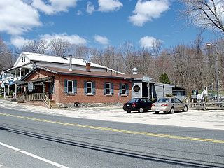
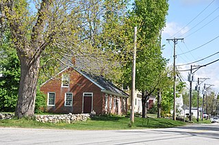
The Jewell Town District of South Hampton, New Hampshire, encompasses a colonial-era industrial village with a history dating to 1687. It is centered at the junction of West Whitehall and Jewell Streets, which is just south of a bend in the Powwow River, the source of the power for the mills that were built here. The area was settled in 1687 by Thomas Jewell, and by the early 19th century included a variety of mills as well as a bog iron works. The district now includes only remnants of its industrial past, and features a collection of 18th and early-19th century residential architecture. The district was listed on the National Register of Historic Places in 1983.
The Charlotte Center Historic District encompasses the historic 19th-century town center of Charlotte, Vermont. Settled c. 1790 and developed mainly in the mid-19th century, the village, stretched along Church Hill Road west of Hinesburg Road, retains a well-preserved 19th-century atmosphere of residential, civic, and commercial buildings. The district was listed on the National Register of Historic Places in 1984.


