Humberstone & Hamilton

Last updated

Humberstone & Hamilton
LeicesterHumberstoneHamiltonWard.svg
Leicestershire UK location map.svg
Red pog.svg
Humberstone & Hamilton
Location within Leicestershire
Population18,854 (2011)
Unitary authority
Ceremonial county
Region
Country England
Sovereign state United Kingdom
Post town LEICESTER
Postcode district LE5
Dialling code 0116
Police Leicestershire
Fire Leicestershire
Ambulance East Midlands
UK Parliament
List of places
UK
England
Leicestershire
52°39′14″N1°03′54″W / 52.654°N 1.065°W / 52.654; -1.065 Coordinates: 52°39′14″N1°03′54″W / 52.654°N 1.065°W / 52.654; -1.065

Humberstone & Hamilton is an electoral ward and administrative division of the City of Leicester, England. It comprises the north-eastern Leicester suburbs of Humberstone, Humberstone Garden City, Hamilton and Netherhall.

Contents

Geography

Humberstone & Hamilton is bordered by the wards of Rushey Mead to the north, Charnwood to the east and Coleman and Thurncourt to the south. [1] The ward borders the county of Leicestershire; in particular, the borough of Charnwood to the north and the district of Harborough to the east.

The ward comprises the suburb of Humberstone in the west, Netherhall in the southeast and Hamilton to the northeast (which makes Hamilton the most northeasterly suburb of Leicester).

History

Name

The ward takes its name from the historical village of Humberstone and the modern housing estate of Hamilton. The place-name 'Humberstone' is first attested in the Domesday Book of 1086, where it appears as 'Humerstane'. The name means 'Hunbeorht's stone'. [2] The "Humber stone" is a granite monolith of unknown (perhaps glacial) origin that lies in a field in Hamilton. Until 1750 it had been fully exposed, but was then truncated and the remainder buried by a farmer. In the 1980s it was partially uncovered and made accessible to the public. It was then fenced in when the Leicester north ring road was built and had a sign erected at the site, describing the stone's history.

Hamilton was named after a deserted medieval village in the civil parish of Barkby Thorpe, just outside the Leicester city boundary. The name is being revived for new developments on the A563 road, east of Rushey Mead. [3]

Medieval history

The village of Humberstone has been inhabited for many centuries. Part of the wall around the local St Mary's church is an original cob wall. There is also a thatched cruck cottage dating from a similar time. Most of the houses in Humberstone were built in the 1920s on land that used to be part of the estate of Humberstone Hall. Some of the gardens in the area bear testament to this as they still have parts of the century-old orchard trees in them.

Humberstone was annexed to the city in 1935. In the late 1980s and early 1990s several private gardens were sold to property developers, but a combination of local hostility and a crash in the property market resulted in the land becoming disused. It has since been taken over by the council and converted into a public garden.

Humberstone Garden development

The development of Humberstone Garden was based on the principles of the Garden city movement. Garden suburbs modified the principles of garden cities to allow for residential "garden suburbs" without the commercial and industrial components of the garden city. They were built on the outskirts of cities, in rural settings such as Humberstone.

The Humberstone Garden Suburb is notable because it is the only example in which a UK workers cooperative has created a housing cooperative and built a housing estate for its members. The Anchor Tenants Housing Association was formed in 1887 by the workers cooperative of the Anchor Boot and Shoe Co-operative Society which was a cooperatively run boot and shoe works in Asfordby Street, Leicester. The members of the cooperative contributed a percentage of their wages and bought a plot of land just outside Leicester by the village of Humberstone and built 97 houses. The first houses were in use by 1908 and the Anchor employees were let houses by the association at a rent that was collected to cover the upkeep of the properties. [4] The original houses were designed by George Hern in a roughcast cottage style at a density of seven to eight houses an acre. The suburb consists of houses in Lilac Avenue, Laburnum Road, Fern Rise, Chestnut Avenue and a part of Keyham Lane. The names of the new streets were chosen to emphasise the garden nature of the scheme. [5]

Demographics

Humberstone & Hamilton had a population of 11,893 at the 2001 census. The ward had a relatively older population, with the greatest share of the area's residents being between the ages of 30 and 59.

Compared to some Leicester wards, Humberstone & Hamilton's Asian population was a minority at 19%, with a 73% white British population. [6]

In 2011 however, 43.8% of the population of this ward were White British, 40.1% were Asian and 4.4% Black. [7]

Amenities and facilities

Until the mid-1980s Humberstone village had two pubs, The Humberstone (which still exists and which in about 1960 replaced The Plough which stood closer to the road ) and The Windmill (which lay derelict until the late 1990s when it was demolished). The village is also home to two members' clubs, the Humberstone Royal British Legion and the Old Humberstone Constitutional Club.

The original public library was on Main Street - a small building on the left hand side going down the hill which resembled a non-conformist chapel. This was eventually replaced by a public library situated next to the school, but was relocated to the car park of the nearby Hamilton Tesco Extra store in the mid-2000s.

Humberstone has a bowls club and a youth football club, Humberstone Rangers. There was a tennis club in the village until the mid-2000s when it was demolished and houses built there. The local golf club, Humberstone Heights, is one of the few council-run clubs in the city.

When it was built, Humberstone Garden Suburb had a bowling green, a cricket pitch, a skittle alley, a football ground, tennis courts and golf links. [8] These facilities and the shoe factory no longer exist but the housing estate remains intact.

Education

Humberstone Nursery, Infants and Junior School are located adjacent to each other in Humberstone. Humberstone Juniors converted to an academy in 2012. In 2014 Falcons Primary School opened in the area. It is a Sikh free school. [9]

There are two primary schools in Hamilton; Kestrel's Field Primary School, which opened in the early 1990s, and Hope Hamilton, which is Church of England aided.

Orchard Mead Academy is attended by students between the ages of 11 to 16. Nearby Keyham Lodge School is an all-boys school for 11–16s with learning disabilities and behavioural problems. Gateway Sixth Form College has recently opened a building opposite the Tesco store, with a pedestrian footbridge across the outer ring road between the college and Tesco.

Transport

Humberstone & Hamilton are served by the following bus companies and services: First Leicester routes 21A & 38/38A, Arriva Fox County services 53/53A, 56, 58/58A and Centrebus services 40, 747 and UHL.

Humberstone used to have a station on the Leicester spur of the Great Northern Railway, named Humberstone Railway Station. This was on Uppingham Road to the west of the old village. Further to the west, Humberstone Road railway station was on the Midland Main Line.

Politics

Humberstone & Hamilton is part of the Leicester East constituency, a traditionally safe Labour seat.

Related Research Articles

Loughborough Town in Charnwood, Leicestershire, England

Loughborough is a large market town in the Charnwood borough of Leicestershire, England, seat of Charnwood Borough Council and Loughborough University. Is 59,933 inhabitants in the 2011 census were estimated at 67,956 in 2019, as the county's second largest settlement. It is close to the Nottinghamshire border and at short distances from Leicester, Nottingham, East Midlands Airport and Derby. It has the world's largest bell foundry, John Taylor Bellfounders, which made bells for the Carillon War Memorial, a landmark in the Queens Park in the town, of Great Paul for St Paul's Cathedral, and for York Minster.

Belgrave, Leicester Area, suburb, electoral ward and administrative division of the city of Leicester, England

Belgrave is an area, suburb, electoral ward and administrative division of the city of Leicester, England. Belgrave is the location of and known for the National Space Centre, Space Park Leicester, the Golden Mile and Belgrave Hall.

Thurmaston Human settlement in England

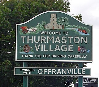
Thurmaston is a village and civil parish in Leicestershire, England, located within the Borough of Charnwood. At the 2011 census, it had a population of 9,668.

Anstey, Leicestershire Human settlement in England

Anstey is a large village in Leicestershire, England, located north west of Leicester in the borough of Charnwood. Its population was 6,528 at the 2011 census. This figure is expected to increase due to the building of a new housing development off Groby Road. The village is separated from Leicester by the Rothley Brook, Castle Hill Park and the A46, and it borders the villages of Glenfield, Groby, Newtown Linford, Cropston and Thurcaston as well as the suburb of Beaumont Leys and Anstey Heights. To the north-west lies Bradgate Park.

Birstall, Leicestershire Human settlement in England

Birstall is a large village and civil parish within the Charnwood borough of Leicestershire, England. It is three miles north of Leicester city centre and is part of the wider Leicester Urban Area.

Leicester East (UK Parliament constituency)

Leicester East is a constituency represented in the House of Commons of the UK Parliament since December 2019 by Claudia Webbe, who was elected as a Labour MP, but currently sits as an Independent due to her suspension from the party in September 2020 after she was charged with harassment.

Garden city movement Urban planning movement

The garden city movement is a method of urban planning in which self-contained communities are surrounded by "greenbelts", containing proportionate areas of residences, industry, and agriculture. The idea was initiated in 1898 by Ebenezer Howard in the United Kingdom and aims to capture the primary benefits of a countryside environment and a city environment while avoiding the disadvantages presented by both. Howard was knighted in 1927. During his lifetime Letchworth, Brentham Garden Suburb and Welwyn Garden City were built in or near London according to Howard’s concept and many other garden cities inspired by his model have since been built all over the world.

Highfields, Leicester

Highfields is an inner city area of Leicester, England. It is one of the highest areas in the city, on high ground southeast of the city centre. To the west the area is bounded by the Midland Main Line, to the south by London Road (A6), and to the east by East Park Road. To the north is Spinney Hills, though there is no clear boundary between the two areas, and Spinney Hills is often considered to be part of Highfields. The neighbourhood is within walking distance of the city centre of Leicester and offers many amenities for religious, social, cultural and commercial activities. The population is split between the Spinney Hills, Wycliffe and Stoneygate wards of the Leicester City Council.

Thurnby Lodge is an estate in eastern Leicester, Leicestershire, England. Roughly, it consists of the area inside the city boundary which is north of the Uppingham Road, east of the A563 outer ringroad, and south of the Scraptoft Lane. Since the core area around Thurncourt Road is a council estate with a negative reputation, many, particular those around the eastern, western and southern fringe, would disassociate their area from Thurnby Lodge.

North Evington Human settlement in England

North Evington is an area, suburb, electoral ward and administrative division of the city of Leicester, England.

Rushey Mead Area, suburb, electoral ward and administrative division of the city of Leicester, England

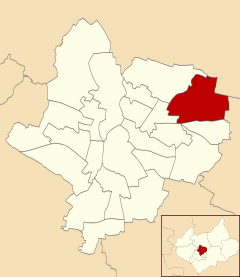
Rushey Mead is an area, suburb, electoral ward and administrative division of the city of Leicester, England. The population of the ward at the 2011 census was 15,962. It comprises the northern Leicester suburb of Rushey Mead in its entirety, as well as a part of the neighbouring area, suburb and electoral ward of Belgrave and historical parts of neighbouring Northfields and Thurmaston.

A607 road

The A607 is an A road in England that starts in Belgrave, Leicester and heads northeastwards through Leicestershire and the town of Grantham, Lincolnshire, terminating at Bracebridge Heath, a village on the outskirts of Lincoln. It is a primary route from Thurmaston to the A1 junction at Grantham.

Eyres Monsell is an electoral ward and administrative division in Leicester, England.

Thurncourt Human settlement in England

Thurncourt is an electoral ward and administrative division of the city of Leicester, England. The population of the ward at the 2011 census was 10,596. It comprises the suburb and housing estate of Thurnby Lodge in eastern Leicester.

Charnwood (ward) Human settlement in England

Charnwood was an electoral ward and administrative division of the city of Leicester, England. The population of the ward at the 2011 census was 13,291. It comprised the northern Leicester suburb of Northfields and its Tailby and Morton ex-council estates. Northfields has had a bad reputation for criminal activities. Despite being only 3 small estates it was responsible for 30% of the crime rate within the Leicester area. In response The Northfields Project was set upin order to help to combat crime and make Northfields a safer place to live. The scheme improved areas such as security fencing, lighting and public recreational spaces.

Coleman, Leicester Human settlement in England

Coleman is an electoral ward and administrative division of the city of Leicester, England, consisting of the Leicester suburbs of Crown Hills and North Evington.

2019 Leicester City Council election

The 2019 Leicester City Council election took place on 2 May 2019 to elect all fifty-four members of the Leicester City Council in England. This was on the same day as other local elections, and the election for the directly elected Mayor of Leicester.

References

  1. Leicester City Council. "Ward Maps". Archived from the original on 13 June 2011. Retrieved 11 October 2011.
  2. Eilert Ekwall, Concise Oxford Dictionary of English Place-names, p.256.
  3. "Council News". Leicester City Council.
  4. "Humberstone Garden Suburb". Utopia-britannica.org.uk. Retrieved 10 January 2010.
  5. Pevsner, Nikolaus (1984). Buildings of England:Leicestershire and Rutland (2nd ed.). Penguin. p. 273.
  6. Leicester City Council. "Ward Profiles – 2001 Census – Population". Archived from the original on 15 September 2012. Retrieved 14 November 2011.
  7. "Humberstone and Hamilton". UK Census Data. Retrieved 20 April 2019.
  8. "Humberstone Garden Suburb – A History" (PDF). Retrieved 10 January 2010.
  9. "Leicester Sikh free school to open next month after DfE concerns". BBC. 29 September 2014. Retrieved 20 April 2019.