Huntersville | |
---|---|
Census-designated place (CDP) | |
Coordinates: 38°11′19″N80°0′58″W / 38.18861°N 80.01611°W | |
Country | United States |
State | West Virginia |
County | Pocahontas |
Area | |
• Total | 1.131 sq mi (2.93 km2) |
• Land | 1.131 sq mi (2.93 km2) |
• Water | 0 sq mi (0 km2) |
Population | |
• Total | 73 |
• Density | 65/sq mi (25/km2) |
Time zone | UTC-5 (Eastern (EST)) |
• Summer (DST) | UTC-4 (EDT) |
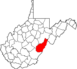
Huntersville is a census-designated place (CDP) located in Pocahontas County, West Virginia, United States in the Alleghany Mountains. As of the 2010 census, its population was 73. [2] It is located six miles east of Marlinton and four miles west of Minnehaha Springs. Huntersville received its name because it was a rendezvous for trappers and hunters who came to trade pelts for supplies. [3] It served as the county seat of Pocahontas County until 1891 when the county's residents voted to move the seat to Marlinton. A local newspaper called The Pocahontas Times is distributed in the area.
Huntersville has many sporting opportunities. Because of its proximity to Knapps Creek flowing nearby, fishermen can catch trout, bass, sun perch, and other fish. Native brook trout streams are also tucked away in quiet places close to the town. Hunting is a big tradition that still lives on in this community because of the vast stretches of Monongahela National Forest that borders the town.
The Huntersville Presbyterian Church was listed on the National Register of Historic Places in 1978. [4]
Pocahontas County is a county located in the eastern part of the U.S. state of West Virginia. As of the 2020 census, the population was 7,869. Its county seat is Marlinton. The county was established in 1821. It is named after the daughter of the Powhatan chief of the Native Americans in the United States who came from Jamestown, Virginia. She married an English settler, and their children became ancestors of many of the First Families of Virginia.
Bluefield is a town in Tazewell County, Virginia, United States, located along the Bluestone River. The population was 5,096 at the 2020 census. It is part of the Bluefield WV-VA micropolitan area which has a population of 106,363 in 2020.
Tazewell is a town in Tazewell County, Virginia, United States. The population was 4,627 at the 2010 census. It is part of the Bluefield, WV-VA micropolitan area, which has a population of 107,578. It is the county seat of Tazewell County.
Wardensville is a town in Hardy County, West Virginia, United States. The population was 265 at the 2020 census. Originally named Trout Run, Wardensville was chartered in Virginia in 1832 and incorporated in West Virginia in 1879. Wardensville is located west of the Great North Mountain range, which separates it from the Shenandoah Valley. The town lies on the east bank of the Cacapon River at its confluence with Trout Run. The George Washington and Jefferson National Forests border the town to its east and south.
Franklin is a town in and the county seat of Pendleton County, West Virginia, United States. The population was 486 at the 2020 census. Franklin was established in 1794 and named for Francis Evick, an early settler.
Marlinton is a town in and the county seat of Pocahontas County, West Virginia, United States. The population was 998 at the 2020 census. Located along the Greenbrier River, it is known for its scenic beauty.
The Greenbrier River is a tributary of the New River, 162 miles (261 km) long, in southeastern West Virginia, in the United States. Via the New, Kanawha and Ohio rivers, it is part of the watershed of the Mississippi River, draining an area of 1,656 square miles (4,290 km2). It is one of the longest rivers in West Virginia.
The Williams River is a tributary of the Gauley River, 33 miles (53 km) long, in east-central West Virginia, USA. Via the Gauley, Kanawha and Ohio Rivers, it is part of the watershed of the Mississippi River, draining an area of 132 square miles (342 km²) in a sparsely populated region of the southern Allegheny Mountains and the unglaciated portion of the Allegheny Plateau.
Knapp Creek is a tributary stream of the Greenbrier River in Pocahontas County, West Virginia. Its source is east of the community of Frost on Allegheny Mountain. From its headwaters, Knapp Creek slowly flows down through farmland until its confluence with Laurel Creek at Minnehaha Springs. Downstream from the confluence of the two streams, Knapp Creek flows through Huntersville. Six miles from Huntersville, Knapp Creek empties into the Greenbrier River outside Marlinton.
Cass is a census-designated place (CDP) and unincorporated community on the Greenbrier River in Pocahontas County, West Virginia, United States. The population was 38 at the 2020 census. The community, founded in 1901, was named for Joseph Kerr Cass, vice president and cofounder of the West Virginia Pulp and Paper Company.
Pageton is a census-designated place (CDP) in McDowell County, West Virginia, United States. As of the 2010 census, its population was 187. Pageton is located on the Tug Fork Branch of the Norfolk and Western Railway, along the Pocahontas seam of rich bituminous coal. Pageton is located on State Route 161 between Thorpe and Anawalt.
Landgraff is an unincorporated community in McDowell County, West Virginia, United States. It is located along U.S. Route 52 and Elkhorn Creek, approximately 6.4 miles (10.3 km) east of the county seat of Welch.
This is a list of the National Register of Historic Places listings in Pocahontas County, West Virginia.
Bartow is a census-designated place (CDP) in Pocahontas County, West Virginia, United States. The population was 111 at the 2010 census.
Slaty Fork is an unincorporated community in Pocahontas County, West Virginia, United States. Slaty Fork is located along U.S. Route 219, 13.5 miles (21.7 km) north of Marlinton.
Linwood is an unincorporated community in Pocahontas County, West Virginia, United States. Linwood is located at the junction of U.S. Route 219 and state routes 55 and 66, 14 miles (23 km) north-northeast of Marlinton.
Edray is an unincorporated community in Pocahontas County, West Virginia, United States. Edray is located near U.S. Route 219 and West Virginia Route 55, 3.5 miles (5.6 km) north of Marlinton. It is home to the Edray State Trout Hatchery.
Sitlington is an unincorporated community in Pocahontas County, West Virginia, United States. Sitlington is located at the confluence of the Greenbrier River and Sitlington Creek, 13 miles (21 km) northeast of Marlinton.
Woodrow is an unincorporated community in Pocahontas County, West Virginia, United States. Woodrow is 5.5 miles (8.9 km) northwest of Marlinton.
Marlinton Chesapeake and Ohio Railroad Station was a historic railway station and bunkhouse located at Marlinton, Pocahontas County, West Virginia. They were built in 1901 by the Chesapeake and Ohio Railroad. The station was a frame, rectangular, one-story building measuring 76 feet by 16 feet and used for both passengers and freight. The bunkhouse is a one-story frame building measuring 24 feet by 16 feet. Both buildings featured vertical board and batten siding and decorative brackets in the wide projecting eaves of their gable roofs. Passenger service ended at Marlinton in 1958. Given its location at the trailhead of the Greenbrier River Trail, the station was renovated to house the Pocahontas County Convention and Visitors Bureau. The station was destroyed by fire in 2008; the bunkhouse remains extant.