Westfield is a city in Hampden County, in the Pioneer Valley of western Massachusetts, United States. Westfield was first settled by Europeans in 1660. It is part of the Springfield, Massachusetts Metropolitan Statistical Area. The population was 40,834 at the 2020 census.
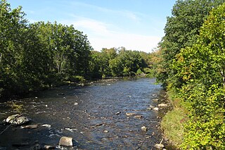
The Westfield River is a major tributary of the Connecticut River located in the Berkshires and Pioneer Valley regions of western Massachusetts. With four major tributary branches that converge west of the city of Westfield, it flows 78.1 miles (125.7 km) before its confluence with the Connecticut River at Agawam, across from the city of Springfield's Metro Center district. Known for its whitewater rapids and scenery, the Westfield River provides over 50 miles (80 km) of whitewater canoeing and kayaking, in addition to one of the largest roadless wilderness areas remaining in the Commonwealth.

The Russells Mills Village Historic District is a historic district on Russells Mills, Rock O' Dundee, Slades Corner, Horseneck and Fisher Roads in Dartmouth, Massachusetts. It encompasses an area that was an early industrial center, flourishing from the 18th century into the early 19th century. The district was added to the National Register of Historic Places in 1985.

The South Lee Historic District encompasses the historic portion of the village of South Lee in Lee, Massachusetts. Extending mainly along Massachusetts Route 102 between Fairview Street and the Stockbridge town line, the village is a well-preserved 19th-century mill village, with fine Federal and Greek Revival buildings and a later 19th-century paper mill. It was listed on the National Register of Historic Places in 1999.

The South Worthington Historic District is a historic district encompassing the formerly industrial, but now rural, village of South Worthington, Massachusetts. The village is centered on the junction of Huntington Road, Ireland Street, and Thrasher Hill Road. The district extends along Ireland Road as far as Conwell Road, and one contributing element, the dam which impounds Little Galilee Pond, extends into neighboring Chesterfield. The area had a number of small mills along the banks of the Little River, a tributary of the Westfield River, but only one complex, the Theron Higgins Mill on South Worthington Road, has survived from the 19th century. Most of the buildings in the district are residences dating to the 19th century; also included are three churches, including the particularly elegant Greek Revival South Worthington Methodist Church (1848). The district was added to the National Register of Historic Places in 2005.

The Hadley Center Historic District is an expansive, 2,500-acre (1,000 ha) historic district encompassing the village center of Hadley, Massachusetts. When it was first listed on the National Register of Historic Places in 1977, the district encompassed the town green and 17 buildings that faced it, at the junction of Russell Street and Middle Street. The district was expanded significantly in 1994, adding more than 400 buildings representative of the village's growth from colonial days into the first decades of the 20th century. This expansion encompasses the entirety of a tongue of land extending west from East Street and bounded by a bend in the Connecticut River, which separates Hadley from Northampton. Its oldest property, the Samuel Porter House on West Street, was built in 1713.
The North Chester Historic District is a historic district encompassing the rural village center of North Chester in the town of Chester, Massachusetts. One of the rural community's early settlement nodes, it thrived into the early 19th century around a stagecoach tavern, a few small mills, and farming, and retains buildings and archaeological remains representative of this history. The district was listed on the National Register of Historic Places in 1998.

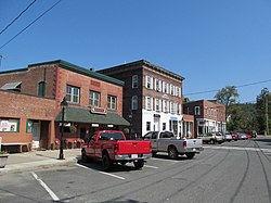
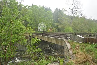
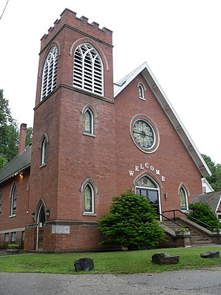
The Russell Center Historic District is a historic district encompassing the historic village center of Russell, Massachusetts. It is centered at the junction of Main Street and Lincoln Avenue, and is bordered by the Westfield River to the east, and the rising foothills of The Berkshires to the west. The village's 19th century development was spurred by the railroad and sustained by local papermaking businesses. It was listed on the National Register of Historic Places in 1996, and was named as one of the 1,000 places to visit in Massachusetts by the Great Places in Massachusetts Commission.

The Graniteville Historic District of Westford, Massachusetts, United States, encompasses one of the town's historic 19th century industrial villages. The area was, until the arrival of the railroad in 1847, primarily known for its granite quarries. The railroad's arrival prompted the construction of an industrial mill by Charles G. Sargent, and the area developed rapidly thereafter. A significant amount of housing stock, as well as civic institutional buildings, were built during the second half of the 19th century. The district is bounded on the east by River Street and on the south by Bridge Street and North Main Street. The western edge of the district runs just before North Main Street's junction with West Street, northward and then eastward to encompass a number of quarry sites, before meeting North Main Street at River Street.

The Hollis Village Historic District encompasses the historic village center of Hollis, New Hampshire. The district is centered on Monument Square, which connects Main Street to Depot Street and Broad Street. It covers about 400 acres (160 ha), and extends along all three of those roads for some distance, and includes properties on Silver Lake Road and Ash Street. Most of the buildings in the district are residential or agricultural in use, and date before the turn of the 20th century; the oldest buildings date to the mid-18th century. The "Always Ready Engine House", which occupies a triangular parcel at the western end of Monument Square, was built in 1859, and is the town's oldest municipal building. Its most architecturally sophisticated building is the town hall, built in 1887 to a design by William M. Butterfield of Manchester. The district represents the growth of a mainly agricultural community over a 200-year period. The district was listed on the National Register of Historic Places in 2001.

The Westfield Center Historic District is a historic district encompassing 157 acres (64 ha) of the civic, commercial, and industrial heart of Westfield, Massachusetts. It represents a major expansion of the Westfield Center Commercial Historic District, which included only two blocks of buildings along Elm Street in downtown Westfield. The district includes buildings representing the city's growth in the 19th century as a center of the whip-making industry, and its early years as a center for statewide educational institutions, as well as its growth as a regional center of western Hampden County. The commercial district was added to the National Register of Historic Places in 2008; the expansion and renaming of the district took place in 2013.

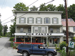
The West Chesterfield Historic District is a historic district that encompasses the 19th century industrial and residential heritage of the village of West Chesterfield in the town of Chesterfield, Massachusetts. Centered at the junction of Main Road and Ireland Street, it was one of the town's main industrial sites for many years. The district was listed on the National Register of Historic Places in 2008.

The Jewell Town District of South Hampton, New Hampshire, encompasses a colonial-era industrial village with a history dating to 1687. It is centered at the junction of West Whitehall and Jewell Streets, which is just south of a bend in the Powwow River, the source of the power for the mills that were built here. The area was settled in 1687 by Thomas Jewell, and by the early 19th century included a variety of mills as well as a bog iron works. The district now includes only remnants of its industrial past, and features a collection of 18th and early-19th century residential architecture. The district was listed on the National Register of Historic Places in 1983.

The Grafton Village Historic District encompasses the historic village center of the town of Grafton, Vermont. The village was developed in the early-to-mid 19th century, and has retained the character of that period better than many small communities in the state. The district was listed on the National Register of Historic Places in 2010.
The South Londonderry Village Historic District encompasses a significant portion of the historic developed area of the village of South Londonderry, Vermont. The village has a well-preserved mid-19th century core, with most of its major development history taking place between about 1806 and 1860. The district was listed on the National Register of Historic Places in 1986.

The Bethel Village Historic District encompasses the historic core of the village of Bethel in the town of Bethel, Vermont, USA. The L-shaped district extends along Main and Church Streets, including many of the village's commercial and civic buildings, as well as a significant number of 19th and early 20th-century residences. The district was listed on the National Register of Historic Places in 1976, and was slightly enlarged in 1990.
The Springfield Downtown Historic District encompasses the historic central business district of the town of Springfield, Vermont. Located in a narrow valley on the banks of the Black River, the town's architecture is primarily reflective of its importance as a manufacturing center in the late 19th and early-to-mid 20th centuries, with a cluster of commercial buildings surrounded by residential and industrial areas. It was listed on the National Register of Historic Places in 1983, and enlarged slightly in 1986.

The Thetford Center Historic District encompasses the village of Thetford Center in Thetford, Vermont. The village contains a well-preserved collection of early to mid-19th century architecture, a legacy of its period of greatest prosperity as an agricultural and industrial center. It was listed on the National Register of Historic Places in 1998.

The Warren Village Historic District encompasses the village center of Warren, Vermont, United States. Stretched mainly along Main Street east of the Mad River, it is a well-preserved 19th-century mill village, although most of its period mill infrastructure has been lost. The district has good examples of Greek Revival, Italianate, and Second Empire architecture. It was listed on the National Register of Historic Places in 1992.

The Newport Downtown Historic District encompasses most of the historic downtown area of the city of Newport, Vermont. The city developed as a transit hub and tourist area in the second half of the 19th century, spurred by the construction of a railroad to the area. The district, roughly bounded by Third Street, Coventry Street, and Lake Memphremagog, was listed on the National Register of Historic Places in 2006.