Meteorological history | |
---|---|
Formed | September 30,1972 |
Dissipated | October 7,1972 |
Category 2 hurricane | |
1-minute sustained (SSHWS/NWS) | |
Highest winds | 100 mph (155 km/h) |
Lowest pressure | 971 mbar (hPa);28.67 inHg |
Overall effects | |
Fatalities | 1 direct,9 indirect |
Damage | $10 million (1972 USD) |
Areas affected | Baja California,California,Arizona,New Mexico |
IBTrACS | |
Part of the 1972 Pacific hurricane season |
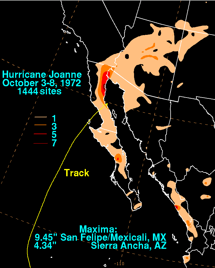
Hurricane Joanne was one of four tropical cyclones to bring gale-force winds to the Southwestern United States in the 20th century. A tropical depression developed on September 30,1972. It then moved west northwest and intensified into a hurricane on October 1. Hurricane Joanne peaked as a Category 2 hurricane,as measured by the modern Saffir-Simpson hurricane wind scale (SSHWS),October 2. Joanne then slowed and began to re-curve. Joanne made landfall along the northern portion of the Baja California Peninsula as a tropical storm. The tropical storm moved inland over Sonora on October 6 and was believed to have survived into Arizona as a tropical storm. In Arizona,many roads were closed and some water rescues had to be performed due to a prolonged period of heavy rains. One person was reportedly killed while another was electrocuted. A few weeks after the hurricane,Arizona would sustain additional flooding and eight additional deaths.
On September 26, ship reports and satellite imagery indicated an area of squally weather about 300 mi (485 km) south of Guatemala. During September 27 and September 28, the disturbance moved westward. On September 29, the disturbance developed a closed low-level atmospheric circulation. [1] The following day, the system was designated as a tropical storm [2] after a ship reported winds of 45 mph (70 km/h). A Hurricane Hunter aircraft investigated the growing storm on October 1 and estimated maximum sustained winds of 75 mph (120 km/h), making Joanne a Category 1 hurricane. However, very few ships reported winds greater than 30 mph (50 km/h) at that time. [1] On October 2, the EPHC classified Joanne as a Category 2 system on the Saffir-Simpson Scale. Furthermore, Joanne was estimated to have attained its peak intensity of 100 mph (160 km/h). [2]
On October 4, Joanne began to recurve, and developed winds of 90 mph (145 km/h). Later that day, the Eastern Pacific Hurricane Center (EPHC) downgraded Joanne into a tropical storm as the system weakened. [1] Accelerating north and later northeast, Joanne made landfall near Laguna Chapala on Baja California while a tropical storm late on October 5 and moved inland over Sonora on the next day. At the time of its second landfall, the EPHC suddenly stopped tracking the storm altogether, [2] although the Weather Prediction Center believes that Joanne moved northeast into western Pima County while still a minimal tropical storm. Thereafter, Joanne was estimated to have weakened to a depression near Ajo and dissipated near Flagstaff. [3]
The initial disturbance to Joanne brought squally weather to Guatemala. [1] Upon making landfall in Mexico, the highest rainfall total was 9.45 in (240 mm) in San Felipe/Mexicali. [4] Puerto Penasco recorded winds of 50 mph (80 km/h). [1] Further north, Joanne caused heavy surf in California, and brought tropical storm-force winds to the state. [5] [6]
Prior to landfall, flash flood watches were issued for the southern portion of the state. [7] Heavy rainfall was reported throughout Arizona. Over 5 inches (100 mm) was measured at the Mogollon Rim. [8] Many areas of the state received between 1 and 3 inches (25 and 76 mm) of rainfall, with isolated locations receiving over 5 inches (130 mm). [3] In Phoenix, .78 in (20 mm) of rain fell in a four-hour period, compared to the October average of .46 in (12 mm). [9] The Nogales Highway Bridge over the Santa Cruz River was washed away by the flooding. Some secondary roads near Tucson were flooded. Numerous water rescues were conducted in central Tucson since several major streets turned into rivers. [3] Severe flooding was recorded in Clifton, Duncan, and Safford. [8] An official in Maricopa County lost track on the exact number of roads that were closed because of the hurricane. Many neighborhoods in northern Phoenix were evacuated early on October 7 when a canal overflowed its banks due to prolonged rainfall. Downtown, a young man was electrocuted when he tried to remove a downed power line that was on his car. [9] Another person was also killed in the city. [10] Following the storm, heavy rain from Joanne set the stage for additional flooding in mid-to late October from a Gulf of Alaska extratropical cyclone that brought more moisture to the area, [3] causing $10 million (1972 USD) in property damage and eight deaths. [11] Further west in New Mexico, the hurricane produced 2.48 in (63 mm) of precipitation. [12]
Hurricane Joanne was one of only four known Pacific hurricanes to bring gale-force winds to the Continental United States in the 20th century, and was the first since the 1939 California tropical storm. [13] According to the National Weather Service, it was the first time in recorded history that a tropical cyclone had brought gale-force winds to Arizona. [8]
Hurricane Diana was a deadly tropical cyclone which made landfall in Mexico in August 1990. The fourth named storm and second hurricane of the season, Diana developed from a tropical wave in the southwestern Caribbean on August 4. Forming as a tropical depression, the system brushed Honduras before intensifying into a tropical storm the following day. Continuing to gradually strengthen, Diana made its first landfall in Mexico's Yucatán Peninsula as a strong tropical storm late on August 5. The cyclone weakened slightly due to land interaction, before emerging into the Bay of Campeche on August 6. Once over water, warm sea surface temperatures allowed Diana to quickly become a hurricane and later peak as a Category 2 on the Saffir–Simpson hurricane scale on August 7. Shortly thereafter, the storm made landfall near Tampico, Tamaulipas, with winds of 100 mph (160 km/h). Rapid weakening ensued once the storm moved over the high terrain of Mexico, with Diana diminishing to a tropical depression roughly 24 hours after moving onshore. The cyclone later emerged into the Gulf of California on August 9 shortly before dissipating. The remnant disturbance was monitored until losing its identity over Arizona on August 14.
The 1986 Pacific hurricane season featured several tropical cyclones that contributed to significant flooding to the Central United States. The hurricane season officially started May 15, 1986, in the eastern Pacific, and June 1, 1986 in the central Pacific, and lasted until November 30, 1986 in both regions. These dates conventionally delimit the period of each year when most tropical cyclones form in the northeastern Pacific Ocean. A total of 17 named storms and 9 hurricanes developed during the season; this is slightly above the averages of 15 named storms and 8 hurricanes, respectively. In addition, 26 tropical depressions formed in the eastern Pacific during 1986, which, at the time, was the second most ever recorded; only the 1982 Pacific hurricane season saw a higher total.
The 1983 Pacific hurricane season was the longest season ever recorded at that time. It was a very active Pacific hurricane season. The season started on May 15, 1983 in the eastern Pacific, and on June 1, 1983 in the central Pacific, and lasted until November 30, 1983. These dates conventionally delimit the period of each year when most tropical cyclones form in the northeastern Pacific Ocean. During the 1983 season, there were 20 named storms, which was slightly less than the previous season. Furthermore, twelve of those storms became hurricanes. And eight of the storms reached major hurricane status, or Category 3 or higher on the Saffir–Simpson hurricane wind scale (SSHWS). The decaying 1982–83 El Niño event likely contributed to this level of activity. That same El Niño influenced a very quiet Atlantic hurricane season.
The 1972 Pacific hurricane season was an ongoing event in tropical cyclone meteorology. There were few notable storms this year. Only one person was killed and storm effects were almost not serious at all. The most notable systems were Hurricane Celeste and Joanne. Celeste was the strongest storm of the season, and caused heavy damage to Johnston Atoll. Hurricane Joanne brought gale-force winds to the Continental United States and caused flooding in Arizona and northern Mexico, which killed one person. The only other system to directly impact land was Hurricane Annette.
Hurricane Nora was the first tropical cyclone to enter the Continental United States from the Pacific Ocean since Hurricane Lester in 1992. Nora was the fourteenth named tropical cyclone and the seventh hurricane of the 1997 Pacific hurricane season. The September storm formed off the Pacific coast of Mexico, and aided by waters warmed by the 1997–98 El Niño event, eventually peaked at Category 4 intensity on the Saffir–Simpson hurricane scale.
Hurricane Kathleen was a Category 1 Pacific hurricane that had a destructive impact in California. On September 7, 1976, a tropical depression formed; two days later it accelerated north towards the Baja California Peninsula. Kathleen brushed the Pacific coast of the peninsula as a hurricane on September 9 and made landfall as a fast-moving tropical storm the next day. With its circulation intact and still a tropical storm, Kathleen headed north into the United States and affected California and Arizona. Kathleen finally dissipated late on September 11.
Hurricane Lester was the first Pacific tropical cyclone to enter the United States as a tropical storm since 1967. The fourteenth named storm and eighth hurricane of the 1992 Pacific hurricane season, Lester formed on August 20 from a tropical wave southwest of Mexico. The tropical storm moved generally northwestward while steadily intensifying. After turning to the north, approaching the Mexican coast, Lester attained hurricane status. The hurricane reached peak winds of 85 mph (137 km/h) before making landfall on west-central Baja California. The system weakened while moving across the peninsula and then over northwestern Mexico. Not long after entering Arizona, Lester weakened to a tropical depression, and degenerated into an extratropical low on August 24, 1992, over New Mexico. The storm's remnants later merged with the remnants of Hurricane Andrew and another frontal system on August 29.
Hurricane Bridget of June 1971 was one of the worst hurricanes to strike the Mexican city of Acapulco. It formed on June 14 as a tropical depression, which is a minimal tropical cyclone with winds less than gale force. However, it was soon upgraded to a tropical storm, and Bridget steadily intensified to become a hurricane on June 15. After peaking at Category 2 intensity, it weakened to a tropical storm on June 17, then made landfall in Mexico. Hours later, however, it turned offshore as a tropical depression. Bridget dissipated on June 20 after leaving heavy damage and 17 deaths in the Acapulco area.
Hurricane Raymond was the strongest tropical cyclone of the 1989 Pacific hurricane season, peaking as a strong Category 4 hurricane on the Saffir–Simpson hurricane scale. Forming out of a tropical wave on September 25, 1989, the tropical depression slowly tracked northwest before becoming nearly stationary the next day. Shortly after, the depression intensified into Tropical Storm Raymond and took a general westward track. Gradually intensifying, Raymond attained hurricane-status on September 28 and attained its peak intensity on September 30, with winds of 145 mph (233 km/h) and a barometric pressure of 935 mbar. Steady weakening then took place and by October 3, Raymond turned northeast towards land. The storm continued to weaken as it accelerated and eventually made landfall on the Baja California Peninsula as a tropical storm late on October 4 and a second landfall in Sonora, Mexico. Shortly after, Raymond weakened to a depression as it tracked inland. The remnants of the system persisted until October 7 when it dissipated over the Central United States.
Hurricane Irene–Olivia was the first actively tracked tropical cyclone to move into the eastern Pacific Ocean from the Atlantic basin. It originated as a tropical depression on September 11, 1971, in the tropical Atlantic. The cyclone tracked nearly due westward at a low latitude, passing through the southern Windward Islands and later over northern South America. In the southwest Caribbean Sea, it intensified to a tropical storm and later a hurricane. Irene made landfall on southeastern Nicaragua on September 19, and maintained its circulation as it crossed the low-lying terrain of the country. Restrengthening after reaching the Pacific, Irene was renamed Hurricane Olivia, which ultimately attained peak winds of 115 mph (185 km/h). Olivia weakened significantly before moving ashore on the Baja California Peninsula on September 30; the next day it dissipated.
Hurricane Madeline was the second landfalling major hurricane along the Pacific coast of Mexico in a week. Madeline formed on September 29, not far from Central America. The next day, the circulation dissipated, and as a result weakened to a remnant low. Four days later, on October 3, the low regenerated into a tropical depression. The system remained weak for three days as it drifted west-northwest. When it began to recurve towards Mexico on October 6, the cyclone rapidly intensified and eventually made landfall at peak intensity as a Category 4. Shortly after landfall, the cyclone rapidly dissipated.
Hurricane Waldo was a Pacific hurricane whose remnants caused significant flooding in Kansas during October 1985. It was also the only hurricane to make landfall during the extremely active 1985 Pacific hurricane season. The twenty-fourth tropical cyclone, twenty-second named storm, and eleventh hurricane of the season, Waldo originated from a disturbance first detected by ship report on October 5, 1985. After developing into a tropical depression on October 7, it steadily intensified, becoming a tropical storm that day. Waldo reached hurricane intensity on October 8. After peaking as a moderate Category 2 hurricane on the Saffir–Simpson hurricane scale, it re-curved to the east, making landfall at peak intensity near Culiacán. Afterward, it rapidly dissipated. In all, Waldo caused moderate damage in Sonora. The remnants of the storm combined with a cold front over the Great Plains. Significant flooding and one death was recorded in Kansas. Many rivers and creeks overflowed its banks.
Hurricane Newton was one of the few tropical cyclones that were intercepted by Hurricane Hunter flights during the active 1986 Pacific hurricane season. It made landfall on the Baja California Peninsula in September of that year, causing minor damage. Newton was the twenty-first depression, fourteenth named storm, and sixth hurricane of the season. A tropical depression formed near Central America on September 18; two days later, the depression was upgraded into a tropical storm. Moving towards to northwest, Newton strengthened into a hurricane on September 21. After paralleling the coast, Newton move ashore near Cabo San Lucas on September 22. Shortly after entering the Gulf of California, the hurricane attaining its peak intensity of 85 mph (145 km/h). The following day, Newton moved ashore the Mexican mainland. Newton dissipated on September 23. However, the remnants of Newton continued across the United States and eventually emerged into the Atlantic Ocean. While 40 homes lost their roofs, damage in Mexico was fairly minor, and no fatalities were reported in association with Newton, though the remnants produced fairly heavy rains in the Great Plains.
Hurricane Doreen was considered the worst tropical cyclone to affect California in 32 years. The tenth tropical cyclone, fourth named storm, and second hurricane of the otherwise inactive 1977 Pacific hurricane season, it developed on August 13. The depression tracked northwestward, intensifying into Tropical Storm Doreen later that day. Further strengthening occurred over the subsequent days, and Doreen attained its peak as a minimal hurricane early on August 15. Executing a turn towards the north-northwest, Doreen made its first landfall as a Category 1 hurricane on the Saffir–Simpson Hurricane Wind Scale near Puerto San Carlos. Drifting offshore, Doreen made a second and final landfall near the northern portion of the Baja California as a tropical storm before rapidly weakening to a tropical depression. The tropical depression dissipated south of southern California on August 18.
Hurricane Norbert marked the first time a core of a hurricane was fully mapped in three-dimensions. First forming on September 14, 1984 west of the Mexican coast, Norbert gradually intensified, reaching hurricane intensity two days after formation. On September 22, Norbert peaked in strength as a Category 4 hurricane on the Saffir-Simpson Hurricane Scale. While intensifying, Norbert meandered. It moved east, then north, then west, then south, then back towards the east, and finally towards the northeast. After fluctuating in intensity for two more days, Norbert rapidly weakened. It turned towards the northwest and made landfall in southern Baja California Norte as a tropical storm. The combination of Norbert and several other storms left thousands homeless throughout Mexico. The remnants of Hurricane Norbert produced moderate rain over Arizona.
Hurricane Sergio was a powerful and long-lived tropical cyclone that affected the Baja California Peninsula as a tropical storm and caused significant flooding throughout southern Texas in early October 2018. Sergio became the eighth Category 4 hurricane in the East Pacific for 2018, breaking the old record of seven set in 2015. It was the twentieth named storm, eleventh hurricane, and ninth major hurricane of the season.