Haverford Township is a home rule municipality township in Delaware County, Pennsylvania, United States. Haverford is named after the town of Haverfordwest in Wales, United Kingdom. It is a commuting suburb located due west of Philadelphia and is officially known as the Township of Haverford. Despite being under a home rule charter since 1977, it continues to operate under a Board of Commissioners divided into wards, as do "First Class" townships that are still under the Pennsylvania Township Code. Haverford Township was founded in 1682 and incorporated in 1911.

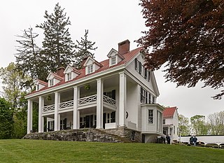
Woodmont is a mansion and hilltop estate of 72 acres (29 ha) in Gladwyne, a suburb of Philadelphia, Pennsylvania, United States. In 1953, it became the home of evangelist Father Divine, and the center of his International Peace Mission movement. It was declared a National Historic Landmark in 1998 for its well-preserved Chateau-style architecture, and for its association with Father Divine.

Gladwyne is a suburban community in Lower Merion Township, Montgomery County, Pennsylvania, United States along the historic Philadelphia Main Line. In 2018, Gladwyne was ranked the 6th richest ZIP code in the country in a study by Bloomberg BusinessWeek. The population was 4,071 at the 2010 US census. As Gladwyne is neither an incorporated area nor a census-designated place, all data are for the ZIP code 19035, with which the community is coterminous.
Penn Valley is an unincorporated community located within Lower Merion Township, Pennsylvania. Penn Valley residents share a zip code with Merion, Narberth, or Wynnewood because the town does not have its own post office. However, Penn Valley is a distinct community whose civic association demarcates the town's boundaries with iconic signs featuring William Penn and a farmhouse in blue or red on white, dating from the town's incorporation in 1930.

The Thaddeus Hait Farm is located on Allhusen Road near the hamlet of Modena in the town of Plattekill, New York, United States. It is a 142-acre (0.57 km2) property on both sides of the road consisting of 15 contributing properties in two distinct groups, together comprising a mostly intact early 19th-century family farm still used for that purpose today.

Ridgedale is a 19th-century Greek Revival plantation house and farm on a plateau overlooking the South Branch Potomac River north of Romney, West Virginia, United States. The populated area adjacent to Washington Bottom Farm is known as Ridgedale. The farm is connected to West Virginia Route 28 via Washington Bottom Road.
York Hill, near Shenandoah Junction, West Virginia is a historic property listed on the National Register of Historic Places. The original log portion of the house was built in the mid-1750s by Samuel Darke on a 360-acre (150 ha) tract conveyed by Thomas Fairfax, 6th Lord Fairfax of Cameron in 1754. The farm passed into the ownership of Colonel James Hendricks in 1762. Upon Colonel Hendricks' death in 1795, the farm was sold into ownership of the Snyder family. Due to heavy tax debt, the Snyder's lost the farm and Robert Hockensmith purchased it in 1939 in partnership with Milton Burr. Mr. Hockensmith later bought out Mr. Burr's share and transferred ownership of the property to his daughter, Mary Frances (Hockensmith) Hockman, upon her marriage in 1955. Upon Ms. Hockman's death in 2007, her son, Gordon Hockman, became the current owner.

Cool Spring Farm, located near Charles Town, West Virginia was first established along Bullskin Run around 1750. The Federal style second house on the property, built in 1813, is extant, with a Greek Revival–influenced third house, built in 1832 that shows the evolution of the farmstead. The farm is significant as an example of agricultural development in the Bullskin Run district and as examples of Greek Revival and Federal style vernacular design.

Ross Farm is a historic farmhouse at 123 Meadow Street in Northampton, Massachusetts. Its importance rests in its significance as the site of a utopian community that operated there from 1841 to 1845, and for its use as a site on the Underground Railroad. Once part of a 300-acre (120 ha) parcel, the property has been reduced to 2.25 acres (0.91 ha), whose only significant structure is the farmhouse which was built in 1825.

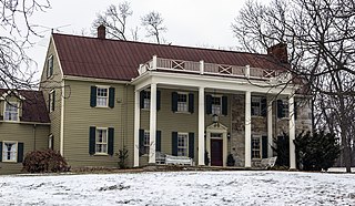
Dolobran is a Shingle Style house at 231 Laurel Lane in Haverford, Pennsylvania. It was designed by architect Frank Furness for shipping magnate Clement Griscom in 1881, and was expanded at least twice by Furness. The house and 146-acre estate served as a summer retreat for Griscom, his wife, and five children.

Hovenden House, Barn and Abolition Hall is a group of historic buildings in Plymouth Meeting, Whitemarsh Township, Montgomery County, Pennsylvania. In the decades prior to the American Civil War, the property served as an important station on the Underground Railroad. Abolition Hall was built to be a meeting place for abolitionists, and later was the studio of artist Thomas Hovenden.

Squire Cheyney Farm is a historic farm and national historic district located in Thornbury Township, Chester County, Pennsylvania. The district encompasses two contributing buildings, three contributing sites, one contributing structure, and contributing object. They are the farmhouse, barn, ruins of a granary, remains of an ice house, a spring house (1799), stone retaining wall, and family cemetery. The house was built in four periods, with the oldest dated to about 1797. The oldest section is a 2 1/s-story, three bay, stuccoed stone structure with a gable roof. The additions were built about 1815, about 1830, and about 1850, making it a seven-bay-wide dwelling. It is "L"-shaped and has a slate gable roof. During the American Revolution, Thomas "Squire" Cheyney [II] informed General George Washington during the Battle of Brandywine that the British were flanking him to the north. He was later appointed to the Pennsylvania Ratifying Convention to ratify the United States Constitution. The site is now a township park known as Squire Cheyney Farm Park.

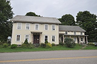
The Lawrence Farm is a historic farm at 9 Lawrence Road in Troy, New Hampshire. Established in the early 19th century, the property has been in continuous ownership by the same family since then. Its farmstead, including a c. 1806 farmhouse, exemplifies the changing trends in domestic agricultural practices of the 19th and 20th centuries. The farm was listed on the National Register of Historic Places in 2000.

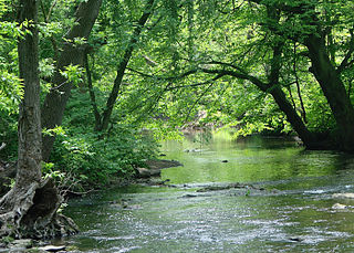
Alapocas Run State Park is a state park, located in Wilmington, Delaware, United States, along the Brandywine Creek and its Alapocas Run tributary. Open year-round, it is 415 acres (168 ha) in area. Much of the state park was created from land originally preserved by William Poole Bancroft in the early 1900s to be used as open space parkland by the city of Wilmington as it expanded. The park also includes the Blue Ball Barn, a dairy barn built by Alfred I. du Pont as part of his Nemours estate in 1914. In addition to walking trails, athletic fields, and playgrounds for children, one of the park's primary features is a rock climbing wall. The rock climbing wall is part of an old quarry across from historic Bancroft Mills on the Brandywine, and the quarry is also used for school educational programs centered on earth sciences.
The Martin M. Bates Farmstead is a historic farm property on Huntington Road in Richmond, Vermont. Farmed since the 1790s, the property is now a well-preserved example of a mid-19th century dairy farm, with a fine Italianate farmhouse. The property was listed on the National Register of Historic Places in 1991.
The Dan Johnson Farmstead is a historic farm property on United States Route 2 in Williston, Vermont. It was first developed in 1787 by Dan Johnson, one of Williston's first settlers, and has remained in his family since that time. The property includes three 19th-century houses and a large barn complex, as well as more than 200 acres (81 ha) of land crossed by US 2 and Interstate 89. It was listed on the National Register of Historic Places in 1993.

The Murray–Isham Farm, or more recently just the Isham Family Farm, is a historic farm property at 3515 Oak Hill Road in Williston, Vermont. The farm has been in active use since about 1850, most of them by the Isham family. The farmstead includes a c. 1850 Gothic Revival house and farm buildings of similar vintage. It was listed on the National Register of Historic Places in 1992, and is the subject of a conservation easement preserving its agricultural character.

Pencoyd was a historic house and farm in Bala Cynwyd, Lower Merion Township, Montgomery County, Pennsylvania. Located along the north side of what is now City Avenue, the farm originally stretched from the Schuylkill River to Conshohocken State Road. Settled by John Roberts in 1683, his descendants owned the property for 280 years. The house was built c.1684–1690, and demolished in 1964.
Wild Goose Farm is a 173-acre (70 ha) farm complex near Shepherdstown, West Virginia, established in the early 19th century. The farm includes a large, irregularly-arranged main house, a Pennsylvania-style bank barn, a tenant house, and outbuildings including a spring house, smoke house, ice house, corn crib, water tower and a decorative pavilion.

Mission Ranch is a historic hotel and restaurant in Carmel-by-the-Sea, Monterey County, California, United States. It is located south of downtown Carmel, near the Carmel Mission, at 26270 Dolores Street. The property was bought in 1986 by Clint Eastwood, who restored the premises in the style of the original buildings. The Mission Ranch includes 22-acre (0.089 km2) with views of Point Lobos, Carmel River Beach and the Pacific Ocean. The Hotel has 31 rooms located within ten buildings on the property.


