Ixonia (CDP), Wisconsin

Last updated

Ixonia, Wisconsin
Ixonia Wisconsin highway sign.jpg
USA Wisconsin location map.svg
Red pog.svg
Ixonia
Usa edcp location map.svg
Red pog.svg
Ixonia
Coordinates: 43°08′38″N88°35′50″W / 43.14389°N 88.59722°W / 43.14389; -88.59722
Country United States
State Wisconsin
County Jefferson
Town Ixonia
Area
  Total3.640 sq mi (9.43 km2)
  Land3.638 sq mi (9.42 km2)
  Water0.002 sq mi (0.005 km2)
Elevation
[1]
856 ft (261 m)
Population
 (2020)
  Total2,367
  Density650/sq mi (250/km2)
Time zone UTC-6 (Central (CST))
  Summer (DST) UTC-5 (CDT)
GNIS feature ID2393065 [1]

Ixonia is a census-designated place (CDP) in the town of Ixonia, Jefferson County, Wisconsin, United States. The population was 2,367 at the 2020 census. [2]

Contents

Geography

Ixonia is located at 43°08′38″N88°35′50″W / 43.14389°N 88.59722°W / 43.14389; -88.59722 (43.1438923, −88.5973230). [3]

According to the United States Census Bureau, the CDP has a total area of 3.0 square miles (7.7 km2), all land.

Demographics

Historical population
CensusPop.Note
2000 642
2010 1,624153.0%
2020 2,36745.8%
U.S. Decennial Census [4]

As of the census of 2000, there were 642 people, 237 households, and 181 families residing in the CDP. The population density was 216.8 people per square mile (83.7/km2). There were 248 housing units at an average density of 32.3 persons/km2 (83.7 persons/sq mi). The racial makeup of the CDP was 98.91% White, 0.16% Native American, 0.16% Asian, and 0.78% from two or more races. Hispanic or Latino of any race were 0.78% of the population.

There were 237 households, out of which 37.6% had children under the age of 18 living with them, 62.4% were married couples living together, 7.2% have a woman whose husband does not live with her, and 23.6% were non-families. 18.6% of all households were made up of individuals, and 6.8% had someone living alone who was 65 years of age or older. The average household size was 2.71 and the average family size was 3.10.

In the CDP, the population was spread out, with 28.0% under the age of 18, 7.9% from 18 to 24, 33.0% from 25 to 44, 21.3% from 45 to 64, and 9.7% who were 65 years of age or older. The median age was 34 years. For every 100 females, there were 110.5 males. For every 100 females age 18 and over, there were 105.3 males.

The median income for a household is $50,341, and the median income for a family was $55,781. Males had a median income of $40,912 versus $24,844 for females. The per capita income for the town was $21,509. 1.1% of the population and 1.6% of families were below the poverty line. Out of the total people living in poverty, 0.0% are under the age of 18 and 10.3% are 65 or older.

Related Research Articles

<span class="mw-page-title-main">Greenhorn, California</span> Census-designated place in California, United States

Greenhorn is a census-designated place (CDP) in Plumas County, California, United States. The population was 236 at the 2010 census, up from 146 at the 2000 census.

<span class="mw-page-title-main">Buckley, Illinois</span> Village in Illinois, United States

Buckley is a village in Artesia Township, Iroquois County, Illinois, United States. The population was 600 at the 2010 census. Buckley celebrated its sesquicentennial in 2006.

Coyne Center is a census-designated place (CDP) in Rock Island County, Illinois, United States. The population was 827 at the 2010 census.

Buechel is a former census-designated place in Jefferson County, Kentucky, United States. The population was 7,272 at the 2000 census. Since 2003, it has been part of the city of Louisville due to a merger between the city and Jefferson County's unincorporated areas. Buechel is now a neighborhood within the city limits of Louisville.

<span class="mw-page-title-main">Seconsett Island, Massachusetts</span> Census-designated place in Massachusetts, United States

Seconsett Island is a census-designated place (CDP) in the town of Mashpee in Barnstable County, Massachusetts, United States. The population was 100 at the 2010 census.

<span class="mw-page-title-main">East Douglas, Massachusetts</span> CDP in Massachusetts, United States

East Douglas is a census-designated place (CDP) in the town of Douglas in Worcester County, Massachusetts, United States. The population was 2,557 at the 2010 census.

<span class="mw-page-title-main">South Woodstock, Connecticut</span> Census-designated place in Connecticut, United States

South Woodstock is a village and census-designated place (CDP) in Woodstock, Windham County, Connecticut, United States. The population was 1,291 at the 2010 census.

<span class="mw-page-title-main">Ashland, New Jersey</span> Populated place in Camden County, New Jersey, US

Ashland is an unincorporated community and census-designated place (CDP) located within Cherry Hill, in Camden County, in the U.S. state of New Jersey. As of the 2010 United States Census, the CDP's population was 8,302.

<span class="mw-page-title-main">Nedrow, New York</span> Census-designated place in New York, United States

Nedrow is a hamlet located in the town of Onondaga in Onondaga County, New York, United States. The population was 2,244 at the 2010 census. It is a suburb of Syracuse, whose southern border it adjoins.

<span class="mw-page-title-main">Oak Hills, Pennsylvania</span> Census-designated place in Pennsylvania, United States

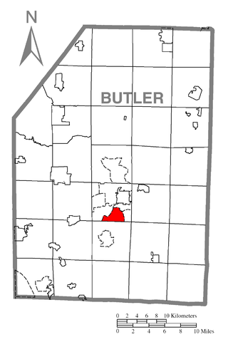
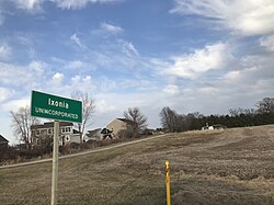
Oak Hills is a census-designated place (CDP) in Butler County, Pennsylvania, United States. The population was 2,333 at the 2010 census.

Forestville is a census-designated place (CDP) in Schuylkill County, Pennsylvania, United States. The population was 431 at the 2000 census.

<span class="mw-page-title-main">Inman Mills, South Carolina</span> CDP in South Carolina, United States

Inman Mills is a census-designated place (CDP) in Spartanburg County, South Carolina, United States. The population was 1,050 at the 2010 census.

<span class="mw-page-title-main">Lake Ripley, Wisconsin</span> Census-designated place in Wisconsin, United States

Lake Ripley is a census-designated place (CDP), in the town of Oakland, Jefferson County, Wisconsin, United States. The population was 1,911 at the 2020 census.

Meadow Acres is a census-designated place (CDP) in Natrona County, Wyoming, United States. It is part of the Casper, Wyoming Metropolitan Statistical Area. The population was 198 at the 2010 census.

<span class="mw-page-title-main">Lake Wisconsin, Wisconsin</span> CDP in Wisconsin, United States

Lake Wisconsin is a census-designated place (CDP) in Columbia and Sauk counties, in the towns of Lodi and Merrimac, in Wisconsin, United States. The population was 4,189 at the 2010 census.

<span class="mw-page-title-main">Middle Village, Wisconsin</span> CDP in Wisconsin, United States

Middle Village is a census-designated place (CDP), in the towns of Menominee and Red Springs, in Menominee and Shawano counties in the U.S. state of Wisconsin. It does not have any legal status as an incorporated municipality. The population was 290 at the 2020 census.

<span class="mw-page-title-main">Minetto (CDP), New York</span> CDP in New York, United States

Minetto is a hamlet in Oswego County, New York, United States. The population was 1,069 at the 2010 census.

The Town of La Valle is located in Sauk County, Wisconsin, United States. La Valle is a name derived from French meaning "the valley". The population was 1,203 at the 2000 census. The Village of La Valle is located within the town.

Riverside is a census-designated place (CDP) in Umatilla County, Oregon, United States. The population was 189 at the 2000 census. It is part of the Pendleton–Hermiston Micropolitan Statistical Area.

<span class="mw-page-title-main">Seymour, Illinois</span> Census-designated place in Illinois, United States

Seymour is a census-designated place in Champaign County, Illinois, United States. At the 2020 census it had a population of 317. It is part of Mahomet-Seymour Community Unit School District No. 3.

References

  1. 1 2 U.S. Geological Survey Geographic Names Information System: Ixonia (CDP), Wisconsin
  2. "U.S. Census website". U.S. Census Bureau . Retrieved April 5, 2011.
  3. "US Gazetteer files: 2010, 2000, and 1990". United States Census Bureau. February 12, 2011. Retrieved April 23, 2011.
  4. "Census of Population and Housing". Census.gov. Retrieved January 1, 2023.