Lake Koshkonong, Wisconsin

Last updated
Lake Koshkonong, Wisconsin
WIMap-doton-Lake Koshkonong.png
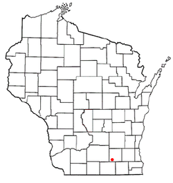
Location of Lake Koshkonong, Wisconsin
Coordinates: 42°51′38″N88°56′25″W / 42.86056°N 88.94028°W / 42.86056; -88.94028 Coordinates: 42°51′38″N88°56′25″W / 42.86056°N 88.94028°W / 42.86056; -88.94028
Country United States
State Wisconsin
County Jefferson
Town Koshkonong, Sumner
Area
  Total29.9 sq mi (77.4 km2)
  Land14.3 sq mi (37.1 km2)
  Water15.6 sq mi (40.3 km2)
Elevation
[1]
781 ft (238 m)
Population
 (2010)
  Total1,204
  Density40/sq mi (16/km2)
Time zone UTC-6 (Central (CST))
  Summer (DST) UTC-5 (CDT)
FIPS code 55-41583 [2]
GNIS feature ID1852244 [1]

Lake Koshkonong is a census-designated place (CDP) in the towns of Koshkonong and Sumner, Jefferson County, Wisconsin, United States. The population was 1,204 at the 2010 census. [3] Lake Koshkonong is in the area.

Contents

Geography

Lake Koshkonong is located at 42°51′38″N88°56′25″W / 42.86056°N 88.94028°W / 42.86056; -88.94028 (42.860475, -88.940344). [4]

According to the United States Census Bureau, the CDP has a total area of 29.9 square miles (77.4 km2), of which 14.3 square miles (37.1 km2) is land and 15.6 square miles (40.3 km2) (52.11%) is water.

Demographics

As of the census [2] of 2000, there were 1,219 people, 492 households, and 338 families residing in the CDP. The population density was 85.2 people per square mile (32.9/km2). There were 809 housing units at an average density of 56.6/sq mi (21.8/km2). The racial makeup of the CDP was 98.36% White, 0.25% Native American, 0.16% Asian, 0.16% from other races, and 1.07% from two or more races. Hispanic or Latino of any race were 1.39% of the population.

There were 492 households, out of which 25.4% had children under the age of 18 living with them, 59.8% were married couples living together, 4.7% had a female householder with no husband present, and 31.1% were non-families. 22.6% of all households were made up of individuals, and 9.8% had someone living alone who was 65 years of age or older. The average household size was 2.48 and the average family size was 2.88.

In the CDP, the population was spread out, with 21.2% under the age of 18, 6.2% from 18 to 24, 26.4% from 25 to 44, 32.1% from 45 to 64, and 14.0% who were 65 years of age or older. The median age was 42 years. For every 100 females, there were 108.0 males. For every 100 females age 18 and over, there were 106.9 males.

The median income for a household in the CDP was $54,412, and the median income for a family was $60,761. Males had a median income of $36,181 versus $25,337 for females. The per capita income for the CDP was $23,801. About 2.9% of families and 5.1% of the population were below the poverty line, including 4.7% of those under age 18 and 2.5% of those age 65 or over.

Related Research Articles

<span class="mw-page-title-main">East Hemet, California</span> Census-designated place in California, United States

East Hemet is a census-designated place (CDP) in Riverside County, California, United States, located east of Hemet. East Hemet is in an unincorporated area outside the city limits of Hemet. The population was 17,418 at the 2010 census, up from 14,823 at the 2000 census.

<span class="mw-page-title-main">Solana, Florida</span> Census-designated place in Florida, United States

Solana is an unincorporated community and census-designated place (CDP) in Charlotte County, Florida, United States. The population was 742 at the 2010 census. It is part of the Punta Gorda, Florida Metropolitan Statistical Area.

<span class="mw-page-title-main">Channel Lake, Illinois</span> Census-designated place in Illinois, United States

Channel Lake is an unincorporated community and census-designated place (CDP) in Antioch Township, Lake County, Illinois, United States. Per the 2020 census, the population was 1,581.

Forest Lake is an unincorporated community and census-designated place (CDP) in Ela Township of Lake County, Illinois, United States. It is about 35 miles (56 km) northwest of downtown Chicago. Per the 2020 census, the population was 1,784. The community was founded in 1935 as a vacation community for Chicago residents.

Fox Lake Hills is an unincorporated community and census-designated place (CDP) in Lake Villa Township, Lake County, Illinois, United States. Per the 2020 census, the population was 2,684.

Lake Catherine is an unincorporated community and census-designated place (CDP) in Lake County, Illinois, United States. Per the 2020 census, the population was 1,279.

Venetian Village is a census-designated place (CDP) in Lake County, Illinois, United States. Per the 2020 census, the population was 2,761.

<span class="mw-page-title-main">Lake Summerset, Illinois</span> Census Designated Place in Illinois, United States

Lake Summerset is a census-designated place (CDP) in Stephenson and Winnebago counties in Illinois. The population was 2,048 at the 2010 census.

<span class="mw-page-title-main">Koshkonong, Missouri</span> City in Missouri, United States

Koshkonong is a city in Oregon County, Missouri, United States. The population was 196 at the 2020 census.

<span class="mw-page-title-main">East Dunseith, North Dakota</span> CDP in North Dakota, United States

East Dunseith is a census-designated place (CDP) in Rolette County, North Dakota, United States. The population was 500 at the 2020 census.

<span class="mw-page-title-main">Three Lakes, Washington</span> CDP in Washington, United States

Three Lakes is a census-designated place (CDP) in Snohomish County, Washington, United States. The population was 3,184 at the 2010 census.

<span class="mw-page-title-main">Koshkonong, Wisconsin</span> Town in Wisconsin, United States

Koshkonong is a town in Jefferson County, Wisconsin, United States. The population was 3,692 at the 2010 census. The town entirely surrounds the city of Fort Atkinson. The unincorporated communities of Koshkonong Mounds and Vinnie Ha Ha are located in the town. The unincorporated communities of Blackhawk Island and Koshkonong, as well as The Census-designated place of Lake Koshkonong are also located partially in the town.

<span class="mw-page-title-main">Bohners Lake, Wisconsin</span> CDP in Wisconsin, United States

Bohners Lake is a census-designated place (CDP) in Racine County, Wisconsin, United States. Its first syllable is pronounced as in "bone". The population of the CDP was 2,444 at the 2010 census. It is politically part of the Town of Burlington, together with Browns Lake, Wisconsin. There has been discussion of incorporating Bohners Lake as a village to prevent annexation by the City of Burlington. It was named for Antony Bohner, a French immigrant who established a resort on the lake of the same name.

<span class="mw-page-title-main">Browns Lake, Wisconsin</span> CDP in Wisconsin, United States

Browns Lake is a census-designated place (CDP) in Racine County, Wisconsin around a lake of the same name. The population was 2,039 at the 2010 census. It is politically a part of the town of Burlington, along with Bohners Lake.

<span class="mw-page-title-main">Eagle Lake, Wisconsin</span> CDP in Wisconsin, United States

Eagle Lake is a census-designated place (CDP) in the town of Dover, Racine County, Wisconsin, United States. The population was 1,192 at the 2010 census.

<span class="mw-page-title-main">Como, Wisconsin</span> CDP in Wisconsin, United States

Como is a census-designated place (CDP), in the town of Geneva, Walworth County, Wisconsin, United States. The population was 2,631 at the 2010 census.

<span class="mw-page-title-main">Delavan Lake, Wisconsin</span> CDP in Wisconsin, United States

Delavan Lake is a census-designated place (CDP) in Walworth County, Wisconsin, United States. The population was 2,649 at the 2010 census. It is located near the shore of Delavan Lake.

<span class="mw-page-title-main">Okauchee Lake, Wisconsin</span> CDP in Wisconsin, United States

Okauchee Lake is a census-designated place (CDP) in Waukesha County, Wisconsin, United States. The population was 4,422 at the 2010 census. Okauchee Lake is located in the town of Oconomowoc.

Meadow Acres is a census-designated place (CDP) in Natrona County, Wyoming, United States. It is part of the Casper, Wyoming Metropolitan Statistical Area. The population was 198 at the 2010 census.

<span class="mw-page-title-main">Powers Lake, Wisconsin</span> Census-designated place in Wisconsin, United States

Powers Lake is a census-designated place (CDP) in the towns of Randall and Wheatland, in Kenosha County in the U.S. state of Wisconsin. As of the 2010 census, the CDP had a population of 1,615. Part of the Powers Lake CDP was in Walworth County, but on December 20, 2011, it became part of the village of Bloomfield.

References

  1. 1 2 U.S. Geological Survey Geographic Names Information System: Lake Koshkonong, Wisconsin
  2. 1 2 "U.S. Census website". United States Census Bureau . Retrieved 2008-01-31.
  3. "U.S. Census website". U.S. Census Bureau . Retrieved 8 April 2011.
  4. "US Gazetteer files: 2010, 2000, and 1990". United States Census Bureau. 2011-02-12. Retrieved 2011-04-23.