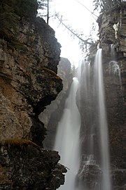
Johnston Creek | |
---|---|
Location | |
Country | Canada |
Province | Alberta |
Physical characteristics | |
Source | |
• location | Badger Pass, Pulsatilla Pass |
• coordinates | 51°23′38″N115°56′52″W / 51.3938°N 115.9478°W |
• elevation | 2,500 meters (8,200 ft) |
Mouth | |
• location | Bow River |
• coordinates | 51°14′30″N115°51′16″W / 51.2417°N 115.8544°W Coordinates: 51°14′30″N115°51′16″W / 51.2417°N 115.8544°W |
• elevation | 1,440 meters (4,720 ft) |
Johnston Creek is a tributary of the Bow River in Canada's Rocky Mountains. The creek is located in Banff National Park.
Johnston Creek originates north of Castle Mountain in a glacial valley southwest of Badger Pass and south of Pulsatilla Pass, at an elevation of 2,500 meters (8,200 ft). The creek flows southeast between Helena Ridge and the Sawback Range, and then south through a gorge known as Johnston Canyon. The stream empties into the Bow River, south of Castle Mountain, between Banff and Lake Louise, at an elevation of 1,440 meters (4,720 ft).
As Johnston Creek approaches the Bow River, it flows through a large canyon formed by erosion over thousands of years. The creek has cut through the limestone rock to form sheer canyon walls, as well as waterfalls, tunnels, and pools.
A popular hiking trail follows the canyon and leads to a meadow within the Johnston Valley above the canyon. The first part of the trail consists of a constructed walkway with safety rails and bridges, while the last part of the trail is natural and more rugged. Within the meadow are the Ink Pots, which are six blue-green spring-fed pools. In August 2018, a few of the "natural" trails near the falls were closed off, in an attempt to help recover the small nesting population of the American black swift. [1]
Ice climbing is a popular activity on the frozen waterfalls in winter.
A tourist lodge and large parking area is located at the foot of the canyon, close to the creek mouth, along the Bow Valley Parkway (Highway 1A).
Yosemite Valley is a glacial valley in Yosemite National Park in the western Sierra Nevada mountains of Central California. The valley is about 7.5 mi (12.1 km) long and 3,000–3,500 ft (910–1,070 m) deep, surrounded by high granite summits such as Half Dome and El Capitan, and densely forested with pines. The valley is drained by the Merced River, and a multitude of streams and waterfalls flow into it, including Tenaya, Illilouette, Yosemite and Bridalveil Creeks. Yosemite Falls is the highest waterfall in North America and is a big attraction especially in the spring, when the water flow is at its peak. The valley is renowned for its natural environment and is regarded as the centerpiece of Yosemite National Park.
Banff National Park is Canada's oldest national park, established in 1885 as Rocky Mountains Park. Located in Alberta's Rocky Mountains, 110–180 kilometres (68–112 mi) west of Calgary, Banff encompasses 6,641 square kilometres (2,564 sq mi) of mountainous terrain, with many glaciers and ice fields, dense coniferous forest, and alpine landscapes. The Icefields Parkway extends from Lake Louise, connecting to Jasper National Park in the north. Provincial forests and Yoho National Park are neighbours to the west, while Kootenay National Park is located to the south and Kananaskis Country to the southeast. The main commercial centre of the park is the town of Banff, in the Bow River valley.
Rocky Mountain National Park is an American national park located approximately 55 mi (89 km) northwest of Denver in north-central Colorado, within the Front Range of the Rocky Mountains. The park is situated between the towns of Estes Park to the east and Grand Lake to the west. The eastern and western slopes of the Continental Divide run directly through the center of the park with the headwaters of the Colorado River located in the park's northwestern region. The main features of the park include mountains, alpine lakes and a wide variety of wildlife within various climates and environments, from wooded forests to mountain tundra.
Mount Forbes is the seventh tallest mountain in the Canadian Rockies and the tallest within the boundaries of Banff National Park. It is located in southwestern Alberta, 18 km (11 mi) southwest of the Saskatchewan River Crossing in Banff. The mountain was named by James Hector in 1859 after Edward Forbes, Hector's natural history professor at the University of Edinburgh during the mid-19th century.
Kootenay National Park is a national park of Canada in southeastern British Columbia. The park consists of 1,406 km2 (543 sq mi) of the Canadian Rockies, including parts of the Kootenay and Park mountain ranges, the Kootenay River and the entirety of the Vermilion River. While the Vermilion River is completely contained within the park, the Kootenay River has its headwaters just outside the park boundary, flowing through the park into the Rocky Mountain Trench and eventually joining the Columbia River. The park ranges in elevation from 918 m (3,012 ft) at the southwestern park entrance to 3,424 m (11,234 ft) at Deltaform Mountain.
The North Cascades are a section of the Cascade Range of western North America. They span the border between the Canadian province of British Columbia and the U.S. state of Washington and are officially named in the U.S. and Canada as the Cascade Mountains. The portion in Canada is known to Americans as the Canadian Cascades, a designation that also includes the mountains above the east bank of the Fraser Canyon as far north as the town of Lytton, at the confluence of the Thompson and Fraser Rivers.
Mount Rundle is a mountain in Canada's Banff National Park overlooking the towns of Banff and Canmore, Alberta. The Cree name was Waskahigan Watchi or house mountain. In 1858 John Palliser renamed the mountain after Reverend Robert Rundle, a Methodist invited by the Hudson's Bay Company to do missionary work in western Canada in the 1840s. He introduced syllabics there—a written language developed for the Cree, as part of his missionary work. He only visited the Stoney-Nakoda of the area around what is now called Mount Rundle in 1844 and 1847.
The Grand Canyon of the Tuolumne is the notable canyon section of the river valley of the Tuolumne River, located within Yosemite National Park, in Tuolumne County and the Sierra Nevada, California.
Cloudland Canyon State Park is a 3,485 acres (14.10 km2) Georgia state park located near Trenton and Cooper Heights on the western edge of Lookout Mountain. One of the largest and most scenic parks in Georgia, it contains rugged geology, and offers visitors a range of vistas across the deep gorge cut through the mountain by Sitton Gulch Creek, where the elevation varies from 800 to over 1,800 feet. Views of the canyon can be seen from the picnic area parking lot, in addition to additional views located along the rim trail. At the bottom of the gorge, two waterfalls cascade across layers of sandstone and shale, ending in small pools below.
Peyto Lake is a glacier-fed lake in Banff National Park in the Canadian Rockies. The lake itself is near the Icefields Parkway. It was named for Bill Peyto, an early trail guide and trapper in the Banff area.
Bow Valley Provincial Park is a provincial park in Alberta, Canada. Established in 1959 in the arch of the Bow River at its confluence with the Kananaskis River, the park is one park of many within the Kananaskis Country park system.
Hamber Provincial Park is a provincial park in British Columbia, Canada, located 130 kilometres (80.7 mi) north of Golden. Straddling the Great Divide on the provincial boundary with Alberta, the park is surrounded on three sides by Jasper National Park and protects the headwaters of the Wood River at Fortress Lake.
Mount Assiniboine Provincial Park is a provincial park in British Columbia, Canada, located around Mount Assiniboine.
The Stanley Mitchell hut is an alpine hut located at an altitude of 2,060 metres (6,759 ft) in the Little Yoho Valley in Yoho National Park, British Columbia. It sits in a small meadow not far from the base of a mountain called The President. It serves as a base for hiking, scrambling, ski-touring and climbing the nearby mountains. The hut is maintained by the Alpine Club of Canada.
Tip Toe Falls, is a 6-foot (1.8 m) tall waterfall on Fall Creek in the Portola Redwoods State Park, California. There is also an 8-foot (2.4 m) upper falls, a few hundred feet upstream, which is much lesser known.
The Banff-Windermere Highway, also known as the Banff-Windermere Parkway, is a 105 km (65 mi) highway which runs through the Canadian Rockies in British Columbia and Alberta in Canada. It runs from Radium Hot Springs, British Columbia to Castle Junction, Alberta, passing through Kootenay National Park and Banff National Park. It is designated as part of British Columbia Highway 93 and Alberta Highway 93.
Havasu Creek is a stream in the U.S. state of Arizona associated with the Havasupai people. It is a tributary to the Colorado River, which it enters in the Grand Canyon.
Wells Gray Provincial Park is a large wilderness park located in east-central British Columbia, Canada. The park protects most of the southern, and highest, regions of the Cariboo Mountains and covers 5,250 square kilometres. It is British Columbia's fourth largest park, after Tatshenshini, Spatsizi and Tweedsmuir.
Helmet Falls is a tiered waterfall located in Kootenay National Park in British Columbia, Canada. With total height of 352 metres (1,155 ft), Helmet Falls is the 11th tallest confirmed waterfall in the Canadian Rockies, as well as one of the most significant waterfalls in British Columbia based on both height and volume.
Mystic Peak is a mountain summit in the Canadian Rockies of Alberta, Canada.