Johnston Canyon
As Johnston Creek approaches the Bow River, it flows through a large canyon formed by erosion over thousands of years. The creek has cut through the limestone rock to form sheer canyon walls, as well as waterfalls, tunnels, and pools.
A popular hiking trail follows the canyon and leads to a meadow within the Johnston Valley above the canyon. The first part of the trail consists of a constructed walkway with safety rails and bridges, while the last part of the trail is natural and more rugged. Within the meadow are the Ink Pots, which are six blue-green spring-fed pools. In August 2018, a few of the "natural" trails near the falls were closed off, in an attempt to help recover the small nesting population of the American black swift. [1]
Ice climbing is a popular activity on the frozen waterfalls in winter.
A tourist lodge and large parking area is located at the foot of the canyon, close to the creek mouth, along the Bow Valley Parkway (Highway 1A).
Gallery
Cascade in Johnston Canyon
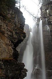
Lower Falls in Johnston Canyon
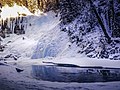
Frozen Lower Falls in Johnston Canyon
Ink Pots
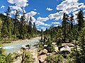
Johnston Canyon in Banff National Park
Ice climbing in Johnston Canyon in December 2016
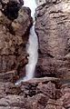
The lower falls pre-1942
A wooden staircase along the creek pre-1942
Two men standing on a wooden bridge over the creek pre-1942
This page is based on this
Wikipedia article Text is available under the
CC BY-SA 4.0 license; additional terms may apply.
Images, videos and audio are available under their respective licenses.