
Meghalaya is a hilly state in northeastern India. The name means "the abode of clouds" in Sanskrit. The population of Meghalaya as of 2016 is estimated to be 3,211,474. Meghalaya covers an area of approximately 22,430 square kilometres, with a length to breadth ratio of about 3:1.
Khasi is an Austroasiatic language spoken primarily in Meghalaya state in India by the Khasi people. It is also spoken by a sizeable population in Assam and Bangladesh. Khasi is part of the Austroasiatic language family, and is related to Khmer, Palaung, Vietnamese and Mon languages of Southeast Asia, and the Munda and Nicobarese branches of that family, which are spoken in east–central India and in the Nicobar Islands, respectively.

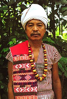
The Khasi people are an indigenous ethnic group of Meghalaya in north-eastern India with a significant population in the bordering state of Assam, and in certain parts of Bangladesh. The Khasi people form the majority of the population of the eastern part of Meghalaya, and is the state's largest community, with around 48% of the population of Meghalaya. They are the only Mon-Khmer speaking people in India and Bangladesh, the others, the Munda are from Austroasiatic family too. A cultural tradition of the Khasi people is that they follow the matrilineal system of descent and inheritance. Under the Constitution of India, the Khasis have been granted the status of Scheduled Tribe.

East Khasi Hills is an administrative district in the state of Meghalaya in India. The district headquarters are located at Shillong. The district occupies an area of 2752 km² and has a population of 825,922. As of 2011 it is the most populous district of Meghalaya's seven districts.

Ri Bhoi is an administrative district in the state of Meghalaya in India. The district headquarters are located at Nongpoh. The district occupies an area of 2378 km² and has a population of 258,840. As of 2011 it is the second least populous district of Meghalaya, after South Garo Hills.

West Khasi Hills is an administrative district in the state of Meghalaya in India.
Kamrup Rural district ; is an administrative district in the state of Assam in India formed by dividing the old Kamrup district into two in the year 2003; other being Kamrup Metropolitan district, named after region it constitute. The district, along with Nalbari, Barpeta, Kamrup Metropolitan, and Baksa districts have been created from the Undivided Kamrup district.
[[File:|thumb|.]]
The Khasi Hills is a low mountain formation on the Shillong Plateau in Meghalaya state of India. The Khasi Hills are part of the Garo-Khasi-Jaintia range and connects with the Purvanchal Range and larger Patkai Range further east. Khasi Hills, and the whole Garo-Khasi-Jaintia range, are in the so-called Meghalaya subtropical forests ecoregion.
Garo, or A·chik, is a Sino-Tibetan language spoken in India in the Garo Hills districts of Meghalaya, some parts of Assam, and in small pockets in Tripura. It is also spoken in certain areas of the neighbouring Bangladesh. According to the 2001 census, there are about 889,000 Garo speakers in India alone; another 130,000 are found in Bangladesh.

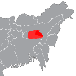
Khasi Hills Autonomous District Council (KHADC) is an autonomous district council in the state of Meghalaya in India. It covers West Khasi Hills district, East Khasi Hills district and Ri Bhoi district. It is one of the three autonomous district councils within Meghalaya, and one of twenty-five autonomous regions of India.
The Karbi language, is spoken by the Karbi people of Northeastern India.
Langpih, also spelt Langpi, Lampi, or Lumpi is a village in northeast India. It is located near the border of West Khasi Hills district, Meghalaya and Kamrup district, Assam. In Meghalaya's administrative structure, it is under Kyrdum gram panchayat, Mawshynrut block, West Khasi Hills district, whereas Assam assigns it to No. 9 Dakhin Pub Boko gram panchayat, Boko-Bongaon block, Kamrup district, with the Postal Index Number 781129.
Amri or Amri Karbi also known as Dumra language is spoken by the plain Karbi people of Assam and hilly Meghalaya. Latin script is used for institutional practice, though authors use both Latin and Assamese script in various publications. The speakers consider their speech as a variety of the Karbi language.

Tiwa (Lalung) is a Tibeto-Burman or Sino-Tibetan language of Assam in North East India.
Conversion from indigenous to Christianity began in the 19th century under the British era. In the 1830s, American Baptist Foreign Missionary Society had become active in Northeast to convert indigenous tribes to Christianity. Later, they were offered to expand and reach into Cherrapunji Meghalaya, but they lacked the resources to do so and declined. Welsh Presbyterian Mission took the offer and they began work at the Cherrapunji mission field. By the early 1900s, other Protestant denominations of Christianity were active in Meghalaya. The outbreak of World Wars forced the preachers to return home to Europe and America. It is during this period that Catholicism took root in Meghalaya and neighbouring region. In the 20th century, Union Christian College started operations at Barapani, Shillong. Currently, Presbyterians and Catholics are two most common Christian denominations found in Meghalaya.

The Cathedral of Mary Help of Christians is a Cathedral in Shillong, Meghalaya. It is the cathedral church of the Roman Catholic Archdiocese of Shillong and serves as the seat of the Metropolitan Archbishop of Shillong. It covers the districts of East Khasi Hills and Ri-Bhoi. The Cathedral is the principal place of worship of the over 300,000 strong Catholics of the Shillong Archdiocese which covers RI Bhoi and East Khasi Hills district of Meghalaya. In all, there are 33 church district's or "Parishes" in the Shillong Archdiocese. The Cathedral Church was built over 50 years ago. This place of worship stands on the very site of the first Church built by the German fathers. The earlier 1913 building – the Church of the Divine Saviour – was a wooden structure. It was destroyed by the Good Friday fire of April 10, 1936. Built by the first Catholic missionaries to arrive at these hills, the Salvatorian Fathers from Germany, it was the first Catholic cathedral church in what was then the Apostolic Prefecture of Assam.

Northeast India consists of the eight states Arunachal Pradesh, Assam, Manipur, Meghalaya, Mizoram, Nagaland, Sikkim and Tripura. Tourism in this area is based around the unique Himalayan landscape and culture distinct from the rest of India.
The People's Democratic Front (PDF) is a regional political party in the Indian state of Meghalaya. The PDF was founded in 2017 and is led by P. N. Syiem and Auspicious L. Mawphlang.

