The Grand Canyon is a steep-sided canyon carved by the Colorado River in Arizona, United States. The Grand Canyon is 277 miles (446 km) long, up to 18 miles (29 km) wide and attains a depth of over a mile.

Bryce Canyon National Park is an American national park located in southwestern Utah. The major feature of the park is Bryce Canyon, which despite its name, is not a canyon, but a collection of giant natural amphitheaters along the eastern side of the Paunsaugunt Plateau. Bryce is distinctive due to geological structures called hoodoos, formed by frost weathering and stream erosion of the river and lake bed sedimentary rock. The red, orange, and white colors of the rocks provide spectacular views for park visitors. Bryce Canyon National Park is much smaller and sits at a much higher elevation than nearby Zion National Park. The rim at Bryce varies from 8,000 to 9,000 feet.

The Mogollon Rim is a topographical and geological feature cutting across the northern half of the U.S. state of Arizona. It extends approximately 200 miles (320 km), starting in northern Yavapai County and running eastward, ending near the border with New Mexico. It forms the southern edge of the Colorado Plateau in Arizona.

The red squirrel or Eurasian red squirrel is a species of tree squirrel in the genus Sciurus common throughout Europe and Asia. The red squirrel is an arboreal, primarily herbivorous rodent.
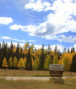
Kaibab National Forest borders both the north and south rims of the Grand Canyon, in north-central Arizona. Its 1.6 million acres is divided into three sections: the North Kaibab Ranger District, the Tusayan Ranger District, and the Williams Ranger District. It is managed by the United States Forest Service. Grand Canyon National Park separates the North Kaibab and the South Kaibab. The South Kaibab covers 1,422 square miles (3,680 km2) and the North Kaibab stretches over 1,010 square miles (2,600 km2). Elevations vary on the forest from 5,500 feet in the southwest corner to 10,418 feet at the summit of Kendrick Peak on the Williams Ranger District. The forest as a whole is headquartered in Williams.

The Coconino National Forest is a 1.856-million acre United States National Forest located in northern Arizona in the vicinity of Flagstaff, with elevations ranging from 2,600 feet to the highest point in Arizona at 12,633 feet. Originally established in 1898 as the "San Francisco Mountains National Forest Reserve", the area was designated a U.S. National Forest by Pres. Theodore Roosevelt on July 2, 1908, when the San Francisco Mountains National Forest Reserve was merged with lands from other surrounding forest reserves to create the Coconino National Forest. Today, the Coconino National Forest contains diverse landscapes, including deserts, ponderosa pine forests, flatlands, mesas, alpine tundra, and ancient volcanic peaks. The forest surrounds the towns of Sedona and Flagstaff and borders four other national forests; the Kaibab National Forest to the west and northwest, the Prescott National Forest to the southwest, the Tonto National Forest to the south, and the Apache-Sitgreaves National Forest to the southeast. The forest contains all or parts of nine designated wilderness areas, including the Kachina Peaks Wilderness, which includes the summit of the San Francisco Peaks. The headquarters are in Flagstaff. The Coconino National Forest consists of three districts: Flagstaff Ranger District, Mogollon Rim Ranger District, and Red Rock Ranger District, which have local ranger district offices in Flagstaff, Happy Jack, and Sedona.

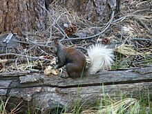
Abert's squirrel or the tassel-eared squirrel is a tree squirrel in the genus Sciurus native to the southern Rocky Mountains from the United States to the northern Sierra Madre Occidental of Mexico, with concentrations found in Arizona, New Mexico, and southwestern Colorado. It is closely associated with, and largely confined to, mature ponderosa pine forests. It is named in honor of the American naturalist John James Abert; nine subspecies are recognised. It is recognizable by its tufted ears, gray color, pale underparts and rufous patch on the lower back. The squirrel feeds on the seeds and cones of the Mexican pinyon and the ponderosa pine when they are available, but will also take fungi, buds, bark, and carrion. Breeding normally occurs in summer, with a spherical nest being built high in the canopy.

The Arizona Strip is the part of Arizona lying north of the Colorado River. Despite being larger in area than several U.S. states, the entire region has a population of fewer than 10,000 people. Consisting of northeastern Mohave County and northwestern Coconino County, the largest settlements in the Strip are Colorado City, Fredonia, and Beaver Dam, with smaller communities of Scenic, Littlefield and Desert Springs. The Kaibab Indian Reservation lies within the region. Lying along the North Rim of the Grand Canyon creates physical barriers to the rest of Arizona. Only three major roads traverse the region, I-15 crosses the northwestern corner while Arizona State Route 389 and U.S. Route 89A crosses the northeastern part of the strip, US 89A crosses the Colorado River via the Navajo Bridge, providing the only direct road connection between the strip and the rest of the state. The nearest metropolitan area is the St. George, Utah metro area, to which the region is more connected than to the rest of Arizona.

The Bolivian squirrel is a tree squirrel that is endemic to South America. Little is known of the species, which may represent a species complex.

The Coconino Plateau is found south of the Grand Canyon and north-northwest of Flagstaff, in northern Arizona of the Southwestern United States.

The Kaibab Plateau is a plateau almost entirely in Coconino County, Arizona in the Southwestern United States. The high plain is also known as the Buckskin Mountain, Buckskin Plateau, and Kaibab Mountain.
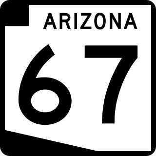
State Route 67 is a 43.4 mi (69.8 km) long, north–south state highway in northern Arizona. Also called the Kaibab Plateau – North Rim Parkway, SR 67 is the sole road that links U.S. Route 89A at Jacob Lake to the North Rim of Grand Canyon National Park. Along the route, the road heads through the national park as well as Kaibab National Forest and traverses extensive coniferous forests. The section inside the national park is maintained by the National Park Service (NPS), whereas the section north of the entrance, completely within Kaibab National Forest, is owned by the Arizona Department of Transportation (ADOT). The road was built in the late 1920s and improved through the 1930s. In 1941, the road received its number, and was given its designation as the parkway in the 1980s. The parkway has received designations as a National Forest Scenic Byway as well as a National Scenic Byway.

The Mount Trumbull Wilderness is a 7,880 acre (31 km2) wilderness area located on the Uinkaret Plateau in the Arizona Strip. It is managed by the Bureau of Land Management.

Jacob Lake is a small unincorporated community on the Kaibab Plateau in Coconino County, Arizona, United States, at the junction of U.S. Route 89A and State Route 67. Named after the Mormon explorer Jacob Hamblin, the town is known as the "Gateway to the Grand Canyon" because it is the starting point of Route 67, the only paved road leading to the North Rim of the Grand Canyon some 44 miles (71 km) to the south. The town itself consists of the Jacob Lake Inn which maintains motel rooms and cabins, a restaurant, lunch counter, gift shop, bakery, and general store; a gas station/garage; campground; and a visitors center run by the U.S. Forest Service. In the summer months, there is also a nearby center for horse rides.

The Arizona gray squirrel is a tree squirrel, in the genus Sciurus, endemic to the canyons and valleys surrounded by deciduous and mixed forests in eastern Arizona and northern Mexico.

The Rocky Mountain ponderosa pine forest is a forest plant community at an elevation of 2,000–2,700 metres (6,600–8,900 ft) in the U.S. state of Colorado, depending on soil moisture. It is an important temperate coniferous forest ecoregion, including some endemic wildlife and grass species that are only found in this ponderosa pine habitat.
The Great Western Trail is a north-south long distance multiple use route that runs from Canada to Mexico through five western states in the United States. The trail has access for both motorized and non-motorized users and traverses 4,455 miles (7,170 km) through Arizona, Utah, Idaho, Wyoming, and Montana. It was designated a National Millennium Trail in 1999.
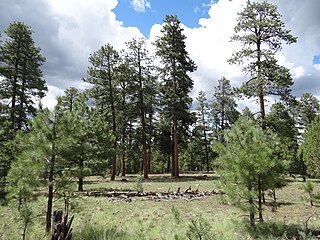
Ponderosa pine forest is a plant association and plant community dominated by ponderosa pine and found in western North America. It is found from the British Columbia to Durango, Mexico. In the south and east, ponderosa pine forest is the climax forest, while in the more northern part of its range, it can transition to Douglas-fir or grand fir, or white fir forests. Understory species depends on location. Fire suppression has led to insect outbreaks in ponderosa pine forests.

There are 67 native species of mammals in Rocky Mountain National Park, a 265,461 acres (107,428 ha) park in Colorado. Species are listed by common name, scientific name, habitat, and abundance. Species which are extirpated, or locally extinct, are marked with an EX.

Shiva Temple is a 7,646-foot-elevation (2,331-meter) summit located in the Grand Canyon, in Coconino County of Arizona, US. It is situated six miles north of Hopi Point overlook of the canyon's South Rim, about 2.5 miles southwest of North Rim's Tiyo Point, and two miles northwest of Isis Temple, where it towers 5,200 feet above the Colorado River. Shiva Temple is named for Shiva, the Hindu deity, destroyer of the universe. This name was applied by Clarence Dutton who began the tradition of naming geographical features in the Grand Canyon after mythological deities. Dutton believed Shiva Temple was the largest, grandest, and most majestic of the Grand Canyon buttes, with a broad, level, forested top. This mountain's name was officially adopted in 1906 by the U.S. Board on Geographic Names.