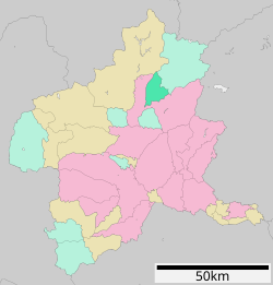
Gunma Prefecture is a landlocked prefecture of Japan located in the Kantō region of Honshu. Gunma Prefecture has a population of 1,937,626 and has a geographic area of 6,362 km2. Gunma Prefecture borders Niigata Prefecture and Fukushima Prefecture to the north, Nagano Prefecture to the southwest, Saitama Prefecture to the south, and Tochigi Prefecture to the east.

Numata is a city located in Gunma Prefecture, Japan. As of 31 July 2020, the city had an estimated population of 46,908 in 20,589 households, and a population density of 110 persons per km2. The total area of the city is 443.46 square kilometres (171.22 sq mi), making it the largest city in terms of area within Gunma Prefecture.

Tatebayashi is a city located in Gunma Prefecture, Japan. As of 1 February 2024, the city had an estimated population of 74,027 in 34,486 households, and a population density of 1200 people per km². The total area of the city is 60.97 square kilometres (23.54 sq mi). Tatebayashi is famous for Azalea Hill Park and Bunbuku Chagama of Morin-ji temple.

Shibukawa is a city in Gunma Prefecture, Japan. As of 31 August 2020, the city had an estimated population of 76,098 in 32,439 households, and a population density of 320 inhabitants per square kilometre (830/sq mi). The total area of the city is 240.27 square kilometres (92.77 sq mi). Shibukawa is the location of Ikaho Onsen, a popular hot spring resort.

Yotsukaidō is a city located in Chiba Prefecture, Japan. As of 1 November 2020, the city had an estimated population of 95,266 in 43,191 households and a population density of 2800 persons per km2. The total area of the city is 34.52 square kilometres (13.33 sq mi).

Yuzawa is a town located in Niigata Prefecture, Japan. As of 1 July 2019, the town had an estimated population of 7,926, and a population density of 22.2 persons per km2. The total area of the town was 357.29 square kilometres (137.95 sq mi). The town is famous for its hot springs.

Shintō is a village located in Gunma Prefecture, Japan. As of 31 August 2020, the village had an estimated population of 15,653 in 5,942 households, and a population density of 520 persons per km². The total area of the village is 27.92 square kilometres (10.78 sq mi).

Yoshioka is a town located in Gunma Prefecture, Japan. As of 1 September 2020, the town had an estimated population of 21,749 in 8,311 households, and a population density of 1100 persons per km2. The total area of the town is 20.46 square kilometres (7.90 sq mi).
Kanra is a town located in Gunma Prefecture, Japan. As of 31 August 2020, the town had an estimated population of 21,749 in 8311 households, and a population density of 220 persons per km2. The total area of the town is 58.61 square kilometres (22.63 sq mi).

Tsumagoi is a village located in Gunma Prefecture, Japan. As of 1 September 2020, the village had an estimated population of 9,546 in 3,999 households, and a population density of 28 persons per km². The total area of the village is 337.51 square kilometres (130.31 sq mi).
Takayama is a village located in Gunma Prefecture, Japan. As of 1 September 2020, the village had an estimated population of 6,889 in 2449 households, and a population density of 110 persons per km2. The total area of the village is 64.18 square kilometres (24.78 sq mi).
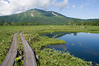
Katashina is a village located in Gunma Prefecture, Japan. As of 31 October 2020, the village had an estimated population of 4,314 in 1694 households, and a population density of 11 persons per km2. The total area of the village is 391.76 square kilometres (151.26 sq mi). m2. Much of the village is within the borders of Oze National Park.

Minakami is a town located in Gunma Prefecture, Japan. As of 31 October 2020, the town had an estimated population of 18,383 in 7938 households, and a population density of 24 persons per km2. The total area of the town is 781.08 square kilometres (301.58 sq mi). Much of the town is within the borders of Jōshin'etsu-kōgen National Park.

Shōwa is a village located in Gunma Prefecture, Japan. As of 1 October 2020, the village had an estimated population of 7,228 in 2751 households, and a population density of 110 persons per km2. The total area of the village is 64.14 square kilometres (24.76 sq mi).

Tone District is a rural district located in Gunma Prefecture, Japan. As of January 2015, the district had an estimated population of 34,946 and an area of 1,322.23 km2, with a population density of 26.4 people per square kilometer.

Tamamura is a town located in Gunma Prefecture, Japan. As of 1 September 2020, the town had an estimated population of 36,367 in 15685 households, and a population density of 1440 persons per km². The total area of the town is 25.78 square kilometres (9.95 sq mi).

Itakura is a town located in Gunma Prefecture, Japan. As of 1 September 2020, the town had an estimated population of 14,323 in 5717 households and a population density of 340 persons per km2. The total area of the town is 41.86 square kilometres (16.16 sq mi). Itakura's animal mascot is the catfish. It is represented in a bronze statue at Raiden Shrine, as a mikoshi in Itakura's summer festival, and also is emblazoned on the town's manhole covers. Itakura is one of the few places in Japan where catfish dishes are a local delicacy.

Minamiuonuma is a city located in Niigata Prefecture, Japan. As of 1 December 2020, the city had an estimated population of 55,354 in 20,047 households, and a population density of 96.1 persons per km². Its total area was 584.55 square kilometres (225.70 sq mi).

Higashiagatsuma is a town located in Gunma Prefecture, Japan. As of 31 July 2020, the town had an estimated population of 13,349 in 2467 households, and a population density of 53 persons per km2. The total area of the town is 253.91 square kilometres (98.04 sq mi).
Usune was a village located in Tone District, northern Gunma Prefecture, Japan.