Buffalo Narrows Airport is located 2 NM east-southeast of Buffalo Narrows, Saskatchewan, Canada.
Cluff Lake Airport(IATA: XCL, TC LID: CJS3) is a decommissioned airstrip located near Cluff Lake mine in north-western Saskatchewan, Canada at the northern terminus of Highway 955.
Collins Bay Airport is located on the west side of Wollaston Lake, on Collins Bay, near Collins Creek, Saskatchewan, Canada.
Estevan Regional Aerodrome is an aerodrome located 3 nautical miles north of Estevan, Saskatchewan, Canada.
Kindersley Regional Airport is located 2.5 nautical miles north of Kindersley, Saskatchewan, Canada.
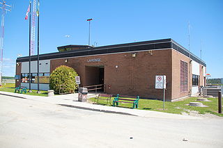
La Ronge Airport is located 2 nautical miles north-east of La Ronge, Saskatchewan, Canada.
Meadow Lake Airport is located 2 nautical miles west of Meadow Lake, Saskatchewan, Canada.
Pinehouse Lake Airport is located adjacent to Pinehouse Lake and serves Pinehouse, Saskatchewan, Canada.
Points North Landing Airport is a regional airport adjacent to Points North Landing in Saskatchewan, Canada.

Prince Albert Airport is located 1 nautical mile northeast of Prince Albert, Saskatchewan, Canada.

Stony Rapids Airport is located adjacent to Stony Rapids, Saskatchewan, Canada.
Tisdale Airport is located adjacent to Tisdale, Saskatchewan, Canada.
Uranium City Airport is located 4 nautical miles east of Uranium City, Saskatchewan, Canada. It is classified as a Code 2 airport.
Wollaston Lake Airport is located adjacent to Wollaston Lake, Saskatchewan, Canada on the Hatchet Lake Dene Nation.
Wynyard/W. B. Needham Field Aerodrome, also known as Wynyard Memorial Airport, is located 2.2 nautical miles north of Wynyard, Saskatchewan, Canada.
Yorkton Municipal Airport is located 2.8 nautical miles north of Yorkton, Saskatchewan, Canada.
Hatchet Lake Airport is located near Hatchet Lake, Saskatchewan, Canada.
Highway 995, also known as Welcome Street, is a provincial highway in the far north region of the Canadian province of Saskatchewan. It is one of the few highways in Saskatchewan that is completely isolated from the other highways. Seasonal access is provided to Highway 905 by way of the Wollaston Lake Barge.
Highway 954 is a provincial highway in the Canadian province of Saskatchewan. It runs from Highway 26 on the north side of Goodsoil to a dead end at Northern Cross Resort on Lac des Îles within Meadow Lake Provincial Park. At the eastern end of the highway is the Goodsoil Airport. It is about 12.9 kilometres (8.0 mi) long.

