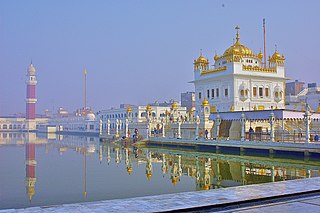
Gurdwara Sri Tarn Taran Sahib is a gurdwara established by the fifth guru, Guru Arjan Dev, in the city of Tarn Taran Sahib, Punjab, India. The site has the distinction of having the largest sarovar of all the gurdwaras. It is famous for the monthly gathering of pilgrims on the day of Amavas. It is near Harmandir Sahib, Amritsar.
Tarn Taran Sahib is a city in the Majha region of the state of Punjab, in northern India. It is the district headquarters and hosts the municipal council of Tarn Taran district. Gurdwara Sri Tarn Taran Sahib, a prominent Sikh shrine is located in the central part of the city.
Khem Karan is a town and a nagar panchayat in Tarn Taran district of Patti tehsil of the Majha region of the Indian state of Punjab.

Majha is a region located in the central parts of the historical Punjab region split between India and Pakistan. It extends north from the right banks of the river Beas, and reaches as far north as the river Jhelum. People of the Majha region are given the demonym "Mājhī" or "Majhail". Most inhabitants of the region speak the Majhi dialect, which is the basis of the standard register of the Punjabi language. The most populous city in the area is Lahore on the Pakistani side, and Amritsar on the Indian side of the border.

Bhawanigarh, earlier known as Dhode, is a town and a municipal council (Class-3) in the Sangrur district in the state of Punjab, India. It is also the headquarters of Bhawanigarh tehsil, which was formed in December 2016. The town is also called Dhode, after the clan of its original founders. The town lies 19 kilometres east of Sangrur on the Patiala-Sangrur road whereas Patiala is 39 kilometres east of Bhawanigarh. The literacy rate is higher than other places of Sangrur. Bhawanigarh is divided into 15 wards. The Bhawanigarh block consists of 66 villages in the Sangrur district.
Bhikhiwind is a town and a nagar panchayat, just about 33 km from Tarn Taran Sahib in Tarn Taran district in the Majha region of state of Punjab, India. The town is located along the India-Pakistan border in Tarn Taran district of Punjab, India, 280 km from Chandigarh.
Tarn Taran district is one of the districts in the Majha region of Punjab, India. The main cities are Tarn Taran Sahib, Bhikhiwind, Khadur Sahib and Patti. The City of Tarn Taran is a holy place for Sikhs.
Patti is an old city, near Tarn Taran Sahib city and a municipal council of the Tarn Taran district in the Majha region of Indian state of Punjab, located 47 Kilometres from Amritsar. Patti city is situated close to the Pakistani border. It is connected through a rail network starting from Amritsar station to Khem Karan station, with Khem Karan being its last station of India.
Dadehar Sahib is a village in Tarn Taran district in the Indian state of Punjab. It is located 30 km away from the Sikh holy city Amritsar and 18 km from Tarn Taran city.
Fatehabad is a small town in the Tarn Taran district of Punjab State. in India, located about 20 km from Tarn Taran Sahib

Chabhal Kalan is a town in the Tarn Taran district of Punjab, India and is located 13 miles (21 km) away from Amritsar city.
Sajjana is a village in Hoshiarpur tehsil of Hoshiarpur district in Punjab, India.
Mao Sahib is a village and the birthplace of Mata Ganga in Jalandhar district of Punjab State, India. It is located 10 km from Phillaur, 14 km from Nurmahal, 47 km from district headquarter Jalandhar and 120 km from state capital Chandigarh. The village is administrated by a sarpanch who is an elected representative of village as per Panchayati raj (India).
Delhi–Amritsar–Katra Expressway is an approved 670 km (420 mi) long, 4-lane wide controlled-access expressway, which will connect Bahadurgarh border near Delhi with Katra in Jammu and Kashmir via Haryana and Punjab. It will have a spur section which will connect Nakodar with Sri Guru Ram Dass Jee International Airport located in Raja Sansi, Amritsar. The 397.7 km (247.1 mi) long Delhi–Nakodar–Katra section is National Expressway 5(NE-5) and 99 km (62 mi) long Amritsar–Nakodar section is National Expressway 5A(NE-5A). Once completed, it will reduce the current Delhi-Katra distance from 727 km (452 mi) to 588 km (365 mi) and the time travel will be reduced from 14 hours to 6 hours, and Delhi-Amritsar distance to 405 km (252 mi) and from the time travel will be reduced from 8 hours to only 4 hours.
Harike is a village located in Patti Tehsil in Tarn Taran district of Punjab state in India. The PIN code of Wakro is 143412. Harike is connected by two national highways, National Highway 54 and National Highway 703B.
Chung is a historical village of Bhikhiwind town in the Indian state of Punjab. Before 1947, it was part of Kasur tehsil of Lahore district. Rice and wheat are the most cultivated crops.
Khadur Sahib is a town and a nagar panchayat in Tarn Taran district of Khadur Sahib tehsil of the Majha region of Indian state of Punjab. Khadur Sahib is a historical place in view of eight out of ten sikh gurus having visited this place. The postal index number of Khadur Sahib is 143117.
Chohla Sahib is a town and a nagar panchayat in Tarn Taran district of the Majha region of Indian state of Punjab. This town is located in Chohla Sahib development block. Chohla Sahib is a historical place in view of two sikh gurus having visited this place. The postal index number of Chohla Sahib is 143408.
The Amritsar–Khem Karan line is a railway route on the Northern Railway zone of Indian Railways. This route plays an important role in rail transportation in Punjab state.
Kasel is a village located in the tehsil of Tarn Taran in Tarn Taran district, in the Indian state of Punjab. The village is 22 km away from the district headquarter of Tarn Taran. Kasel Havelian is the Gram Panchayat of the village. The total population of the village is 5,904 people, out of which 3,113 are males and females are 2,791. The pincode of the village is 143105.


