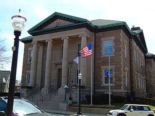
Ashaway is an unincorporated village and census-designated place (CDP) in the town of Hopkinton, Rhode Island, USA. It is a principal village of Hopkinton, along with Hope Valley, although it is the smaller of the two. The population was 1,485 at the 2010 census. The name Ashaway is derived from the American Indian name for the river that runs through the village, the Ashawague or Ashawaug, which means "land in the middle" or "land between" in the Niantic and Mohegan languages. The name "Ashawague River" appears as late as 1832 on the Findley map of Rhode Island published in Philadelphia.

Hope Valley is a village and census-designated place (CDP) in the town of Hopkinton in Washington County, Rhode Island, United States. The population of the CDP was 1,612 at the 2010 census. Hope Valley is the largest village in Hopkinton and the town's principal commercial center. While the village of Hope Valley is located in Hopkinton, its zip code, 02832, extends into the neighboring town of Richmond.

Hopkinton is a town in Washington County, Rhode Island. The population was 8,398 at the 2020 census.

Westerly is a town on the southwestern coastline of Washington County, Rhode Island, first settled by English colonists in 1661 and incorporated as a municipality in 1669. It is a beachfront community on the south shore of the state with a population of 23,359 as of the 2020 census.

The Pawcatuck River is a river in the US states of Rhode Island and Connecticut flowing approximately 34 miles (55 km). There are eight dams along the river's length. USS Pawcatuck was named after the river.

Route 3 is a 30.1-mile-long (48.4 km) state highway in the U.S. state of Rhode Island. Route 3 serves as a local alternative to Interstate 95 (I-95) as it parallels I-95 for almost its entire length. Route 3 in West Warwick was the site of The Station nightclub fire.

Route 91 is a numbered state highway running 12.0 miles (19.3 km) in Rhode Island. Route 91's western terminus is at Route 3 in Westerly and the eastern terminus is at Route 112 in Carolina.
Chariho is a regional school district located in southern Rhode Island shared by three adjacent towns; Charlestown, Richmond, and Hopkinton. The name Chariho is a portmanteau derived by taking the first two letters from each town name and combining them together. The district operates four elementary schools, two of which are located in Hopkinton, in the villages of Ashaway and Hope Valley, one in Charlestown, and one in Richmond. The Chariho campus located in the Richmond village of Wood River Junction houses the Middle and High Schools, as well as the Chariho Career And Technical Center.

Route 216 is a numbered state highway running 8.1 miles (13.0 km) in Rhode Island. Its southern terminus is at U.S. Route 1 in Charlestown, and its northern terminus is at the Connecticut border where it continues as Connecticut Route 216.
Sun Publishing Company is a daily and weekly newspaper publisher in southwest Rhode Island and southeast Connecticut, United States. It is a Westerly, Rhode Island-based subsidiary of RISN Operations.
The Wood River is a river in the U.S. states of Connecticut and Rhode Island. It flows approximately 25 miles (40 km) and is a major tributary of the Pawcatuck River. There are 8 dams along the river's length.

The Green Fall River is a river in the U.S. states of Connecticut and Rhode Island. It flows approximately 13 km (8 mi).
The Ashaway River is a river in the U.S. states of Rhode Island and Connecticut. It flows approximately 4 km (2 mi). There are three dams along the river's length.

Wyoming is a village and census-designated place on the Wood River in southern Rhode Island, primarily in the town of Richmond, Rhode Island, but extending north across the river into the town of Hopkinton, Rhode Island. The population was 270 at the 2010 census. It is the site of the Wyoming Village Historic District and a post office assigned ZIP code 02898.

Washington County, known locally as South County, is a county located in the U.S. state of Rhode Island. As of the 2020 census, the population was 129,839. Rhode Island counties have no governmental functions other than as court administrative boundaries, which are part of the state government.
South Hopkinton is a small village located in the town of Hopkinton, Rhode Island. Residents of South Hopkinton use the zip code for Bradford, Rhode Island, but the village of Bradford is located only within nearby Westerly.
Bethel is a small village located within the town of Hopkinton in the U.S. state of Rhode Island near the Connecticut state border.
Canonchet is a small village in the town of Hopkinton in the U.S. state of Rhode Island. Canonchet is located due northeast of the center of Hopkinton and both Interstate 95 and Rhode Island Route 3 run through the village. Intertstate 95's Exit 2 is located in Canonchet. Canonchet is also the name of a Narragansett sachem in the area who was executed during King Philip's War.
Woodville is a small village in the towns of Richmond and Hopkinton in the U.S. state of Rhode Island.
Hopkinton is a census-designated place (CDP) in Washington County, Rhode Island, United States, comprising the central village in the town of Hopkinton. It was first listed as a CDP prior to the 2020 census. The village is also known as Hopkinton City, and the center of the village comprises the Hopkinton City Historic District.


