Biurrun-Olcoz is a town and municipality located in the province and autonomous community of Navarre, northern Spain.
Park Forest Plaza was a shopping center located in the planned community of Park Forest, Illinois, U.S.A., that opened in 1949. The center was developed by Philip M. Klutznick, (1907-1999), who was also a prominent leader in the national Jewish community and later served as U.S. Secretary of Commerce under 39th President Jimmy Carter. The architects were Loebl, Schlossman and Bennett.

The Kaibab Indian Reservation the home of the Kaibab Band of Paiute Indians, a federally recognized tribe of Southern Paiutes. The Indian reservation is located in northern part of the U.S. state of Arizona. It covers a land area of 188.75 square miles (488.9 km2) in northeastern Mohave County and northwestern Coconino County adjacent to the southern Utah border. The Pipe Spring National Monument lies in the southwestern section of the reservation. The Thunder Mountain Pootseev Nightsky area is located with the reservation.

Pompoï is a department or commune of Balé Province in southern Burkina Faso. Its capital lies at the town of Pompoï. According to the 1996 census the department has a total population of 10,613.

Bagré is a department or commune of Boulgou Province in eastern Burkina Faso. Its capital lies at the town of Bagré. According to the 2006 census, actualized for the municipal élections of 2013, the department has a total population of 29,164.

Bané is a department or commune of Boulgou Province in eastern Burkina Faso. Its capital lies at the town of Bané. According to the 1996 census the department has a total population of 22,923.
Béguédo is a small department or commune of Boulgou Province in eastern Burkina Faso. Its capital lies at the town of Béguédo. According to the 1996 census the department has a total population of 17,880.
Bissiga is a department or commune of Boulgou Province in eastern Burkina Faso. Its capital lies at the town of Bissiga. According to the 1996 census the department has a total population of 19,264.
Bittou is a department or commune of Boulgou Province in eastern Burkina Faso. Its capital lies at the town of Bittou. According to the 1996 census the department has a total population of 34,496.
Garango is a department or commune of Boulgou Province in eastern Burkina Faso. Its capital lies at the town of Garango. According to the 1996 census the department has a total population of 67,737.
Niaogho is a department or commune of Boulgou Province in eastern Burkina Faso. Its capital lies at the town of Niaogho. According to the 1996 census the department has a total population of 25,702.
Zoaga is a department or commune of Boulgou Province in eastern Burkina Faso. Its capital lies at the town of Zoaga. According to the 1996 census the department has a total population of 11,295.
Zonsé is a department or commune of Boulgou Province in eastern Burkina Faso. Its capital lies at the town of Zonsé. According to the 1996 census the department has a total population of 19,916.
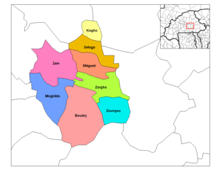
Kogho is a department or commune of Ganzourgou Province in central-eastern Burkina Faso. Its capital lies at the town of Kogho. According to the 1996 census the department has a total population of 15,524.
Méguet is a department or commune of Ganzourgou Province in central-eastern Burkina Faso. Its capital lies at the town of Méguet. According to the 1996 census the department has a total population of 34,668.
Mogtédo is a department or commune of Ganzourgou Province in central-eastern Burkina Faso. Its capital lies at the town of Mogtédo. According to the 2006 general population census, actualized in 2012 for the municipal elections, the department has a total population of 44,668.
Zoungou is a department or commune of Ganzourgou Province in central-eastern Burkina Faso. Its capital lies at the town of Zoungou. According to the 1996 census the department has a total population of 29,753.
Komtoega-Peulh is a village in the Komtoèga Department of Boulgou Province in south-eastern Burkina Faso. As of 2005, the village has a population of 412.
Pissy is a village in the Komtoèga Department of Boulgou Province in south-eastern Burkina Faso. As of 2005, the village has a population of 539.

Ossian Hall was an 18th-century plantation house in Annandale, Fairfax County, Virginia. Ossian Hall was one of three large residences, along with Oak Hill, and Ravensworth, owned by the Fitzhugh family in Fairfax County.


