Kosciuszko's Garden

Last updated
Kosciuszko's Garden
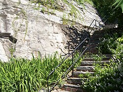
Steps to K's Garden.jpg
Steps leading up from the garden, July 2008
USA New York location map.svg
Red pog.svg
Location West Point, New York
Nearest city Highland Falls, New York
Coordinates 41°23′31″N73°57′13″W / 41.391858°N 73.953583°W / 41.391858; -73.953583
Created1778
Operated byFederal government

Kosciuszko's Garden is a small retreat garden near the Hudson River in New York state. The garden was built by Tadeusz Kosciuszko on the side of a cliff overlooking the Hudson River at West Point. [1] First constructed in 1778, it still offers visitors and cadets a place of quiet tranquility during the warmer months. [2] The "General Edward L. Rowny Family Endowment" was established to further sustain perpetual care and maintenance of the Garden and to dedicate a plaque commemorating the occasion.

Dr. James Thacher described it in his diary, "Colonel Thaddeus Kosciuszko, a gentleman of distinction from Poland...amused himself while stationed on the point, in laying out a curious garden in a deep valley, abounding more in rocks than soil. I was gratified in viewing his curious water fountain with jets and cascades." [3] :71

See also

Related Research Articles

<span class="mw-page-title-main">West Point, New York</span> CDP in New York, United States

West Point is the oldest continuously occupied military post in the United States. Located on the Hudson River in New York, General George Washington stationed his headquarters in West Point in the summer and fall of 1779 during the American Revolutionary War, and later called it "the most important Post in America" in 1781 following the war's end. West Point also was the site of General Benedict Arnold's failed attempt at treason during the Revolutionary War.

<span class="mw-page-title-main">Tadeusz Kościuszko</span> Polish and American military leader (1746–1817)

Andrzej Tadeusz Bonawentura Kościuszko was a Polish military engineer, statesman, and military leader who then became a national hero in Poland, the United States, Lithuania, and Belarus. He fought in the Polish–Lithuanian Commonwealth's struggles against Russia and Prussia, and on the U.S. side in the American Revolutionary War. As Supreme Commander of the Polish National Armed Forces, he led the 1794 Kościuszko Uprising.

<i>Cheval de frise</i> Defensive obstacle

The cheval de frise was a defensive obstacle, existing in a number of forms, principally as a static anti-cavalry obstacle but also quickly movable to close breaches. The term was also applied to underwater constructions used to prevent the passage of ships or other vessels on rivers. In the anti-cavalry role the cheval de frise typically comprised a portable frame with many projecting spikes. Wire obstacles ultimately made this type of device obsolete.

<span class="mw-page-title-main">Hudson River Chains</span> River barriers used during the American Revolutionary War

The Hudson River Chains were a series of chain booms constructed across the Hudson River at West Point by Continental Army forces from 1776 to 1778 during the American Revolutionary War. These served as defenses preventing British naval vessels from sailing upriver and were overseen by the Highlands Department of the Continental Army.

<span class="mw-page-title-main">Fort Lee Historic Park</span> Reconstructed historic site in Fort Lee, New Jersey, United States

Fort Lee Historic Park is located atop a bluff of the Hudson Palisades overlooking Burdett's Landing, known as Mount Constitution, in Fort Lee, New Jersey, United States. The park was conceived as early as 1952.

<span class="mw-page-title-main">Hudson Heights, Manhattan</span> Neighborhood in New York City

Hudson Heights is a residential neighborhood within Washington Heights in Upper Manhattan, New York City. Most residences are apartment buildings, many of which are cooperatives, and most were constructed in the 1920s through 1940s. The Art Deco style is prominent, along with Tudor Revival. Notable complexes include Hudson View Gardens and Castle Village, which were both developed by Dr. Charles V. Paterno, and were designed by George F. Pelham and his son, George F. Pelham, Jr., respectively.

<span class="mw-page-title-main">Garrison, New York</span> Hamlet in New York, United States

Garrison is a hamlet in Putnam County, New York, United States. It is part of the town of Philipstown, on the east side of the Hudson River, across from the United States Military Academy at West Point. The Garrison Metro-North Railroad station serves the town. Garrison was named after 2nd Lieutenant Isaac Garrison, who held a property lot on the Hudson River across from West Point and conducted a ferry service across the Hudson River between the two hamlets. Isaac and his son Beverly Garrison fought in the Battle of Fort Montgomery in 1777, were captured by the British and later set free.

<span class="mw-page-title-main">Hudson River Waterfront Walkway</span> Park in the United States of America

The Hudson River Waterfront Walkway, also known as the Hudson River Walkway, is a promenade along the Hudson Waterfront in New Jersey. The ongoing and incomplete project located on Kill van Kull and the western shore of Upper New York Bay and the Hudson River was implemented as part of a New Jersey state-mandated master plan to connect the municipalities from the Bayonne Bridge to the George Washington Bridge with an urban linear park and provide contiguous unhindered access to the water's edge.

<span class="mw-page-title-main">Battle of Forts Clinton and Montgomery</span> Battle of the American Revolutionary War

The Battle of Forts Clinton and Montgomery was an American Revolutionary War battle fought in the Hudson Highlands of the Hudson River valley, not far from West Point, on October 6, 1777. British forces under the command of General Sir Henry Clinton captured Fort Clinton and Fort Montgomery and then dismantled the first iteration of the Hudson River Chains. The purpose of the attack was to create a diversion to draw American troops from the army of General Horatio Gates, whose army was opposing British General John Burgoyne's attempt to gain control of the Hudson.

Dunderberg Mountain is a 1,086-foot (331 m) mountain on the west bank of the Hudson River at the southern end of the Hudson Highlands. It lies just above Jones Point, New York, within Bear Mountain State Park and the town of Stony Point in Rockland County, New York.

<span class="mw-page-title-main">Fort Nassau (South River)</span>

Fort Nassau was a factorij in New Netherland between 1624–1651 located at the mouth of Big Timber Creek at its confluence with the Delaware River. It was the first known permanent European-built structure in what would become the state of New Jersey. The creek name is a derived from the Dutch language Timmer Kill as recorded by David Pietersen de Vries in his memoirs of his journey of 1630–1633. The Delaware Valley and its bay was called the "South River" ; the "North River" of the colony was the Hudson River. The factorij was established for the fur trade, mostly in beaver pelts, with the indigenous populations of Susquehannock, who spoke an Iroquoian language, and the Lenape, whose language was of the Algonquian family. They also wanted to retain a physical claim to the territory.

The history of the United States Military Academy can be traced to fortifications constructed on the West Point of the Hudson River during the American Revolutionary War in 1778. Following the war, President Thomas Jefferson signed legislation establishing the United States Military Academy (USMA) on the site in 1802. In 1817 the academy was transformed by the appointment of Sylvanus Thayer who drastically reformed the curriculum.

<span class="mw-page-title-main">Constitution Island</span> Island on the Hudson river opposite West Point

Constitution Island is in the northeastern United States, located in New York on the east side of the Hudson River, north of New York City. It is directly opposite the U.S. Military Academy Reservation at West Point and is connected to the east shore by Constitution Marsh.

<span class="mw-page-title-main">The Plain (West Point)</span> Parade field at the US Military Academy

The Plain is the parade field at the United States Military Academy at West Point, New York. The flat terrain of the Plain is in contrast to the varied and hilly terrain of the remainder of the campus. The Plain rises approximately 150 feet (45 m) above the Hudson River and has been the site of the longest continually occupied U.S. Army garrison in America since 1778. In its early years, the entire academy was located on the Plain and it was used for varying activities ranging from drill and mounted cavalry maneuvers to an encampment site for summer training to a sports venue. Currently, the Plain refers to just the parade field where cadets perform ceremonial parades.

<span class="mw-page-title-main">Kosciuszko's Monument (West Point)</span> Statue at the United States Military Academy

Kościuszko's Monument is a pedestal and statue of Polish General Tadeusz Kościuszko at the United States Military Academy at West Point, New York. Kościuszko designed the defenses of the West Point garrison from 1778–1780 during the height of the Revolutionary War, when George Washington considered West Point to be the most important military post in America. The pedestal and shaft of the monument was first proposed in 1825 by John Latrobe, and dedicated in 1828. The statue, designed by D. Borja, was later added in 1913.

<span class="mw-page-title-main">Hudson Waterfront</span> Place in Hudson and Bergen

The Hudson Waterfront is an urban area of northeastern New Jersey along the lower reaches of the Hudson River, the Upper New York Bay and the Kill van Kull. Though the term can specifically mean the shoreline, it is often used to mean the contiguous urban area between the Bayonne Bridge and the George Washington Bridge that is approximately 19 miles (31 km) long. Historically, the region has been known as Bergen Neck, the lower peninsula, and Bergen Hill, lower Hudson Palisades. It has sometimes been called the Gold Coast.

<span class="mw-page-title-main">Palisade Avenue (Hudson Palisades)</span>

Palisade Avenue is the name given to a historic road which parallels the eastern crest of Hudson Palisades in northeastern New Jersey. It travels between Jersey City and Fort Lee, passing through Jersey City Heights, North Hudson, and Cliffside Park, with various parts carrying Hudson and Bergen county route designations. The avenue re-aligns itself at several places along its route as it crosses traditional municipal boundaries created in the 19th century. As a primary route running along the top of the Hudson Palisades, many segments offer scenic views of the Hudson River and the New York skyline. Since 2020 there is proposed state legislation to restrict building heights that would rise above the cliffs on the eastern side of Palisade Avenue along the entire corridor from Jersey City to Fort Lee.

<span class="mw-page-title-main">Fort Putnam</span>

Fort Putnam was a military garrison during the Revolutionary War at West Point, New York, United States. Built by a regiment of Colonel Rufus Putnam's 5th Massachusetts Regiment, it was completed in 1778 with the purpose of supporting Fort Clinton, which sat on the edge of the Hudson River about 3/4 of a mile away. The fort was rebuilt and enlarged in 1794 before falling into disuse and disrepair as the military garrison at West Point became obsolete in the early mid-19th century. It underwent a major preservation as a historical site in 1909, and has been continually in the process of preservation since. Sitting at an elevation of 500 feet, it was West Point's largest garrison during the Revolutionary War. The Fort is under the supervision of the West Point Museum Director, David M. Reel, and is operated by the United States Army Garrison, West Point. Access to the Fort is seasonal and as summer staff are available.

<span class="mw-page-title-main">Redoubt Four (West Point)</span>

Redoubt Four was a supporting defensive position of Fort Putnam during the Revolutionary War defensive network at West Point. It was constructed under the command of Tadeusz Kosciuszko in 1778-1779. During the war, it was a key defensive overwatch position for Fort Putnam 300 feet below, which was in turn the key overwatch position for Fort Clinton. According to Benedict Arnold, the fort required approximately 100 soldiers to man it. The redoubt was partially restored in 1975-1976 as part of the bicentennial celebration. It can be accessed by foot year round from Patrick Trail (road) approximately .5 miles from the West Point Post Exchange complex.

References

  1. "Tour of West Point Kosciuszko'z Garden (Slide 16 of 16)". USMA.edu. Archived from the original on January 5, 2010. Retrieved 2010-01-02.
  2. "FOR YOUR FREEDOM AND OURS". American Association of the Friends of Kosciuszko at West Point, Inc. Retrieved 2009-02-14.
  3. Storozynski, A., 2009, The Peasant Prince, New York: St. Martin's Press, ISBN   9780312388027