
Sirsa is a city and a municipal council in Sirsa district in the westernmost region of the Indian state of Haryana, bordering Punjab and Rajasthan. It is located near to Thar desert or we can say a small portion of Sirsa is under Thar Desert. It is located 250 kilometres north-west of New Delhi and 260 kilometers south-west of state capital Chandigarh. Sirsa Nearest city Hisar, Fatehabad, Bhadra, Nohar, Mandi Dabwali, Hanumangarh. Its history dates back to the time of the Mahabharata. At one time, the Sarasvati River flowed in this area.

Sri Muktsar Sahib district, is one of the 23 districts in the Indian state of Punjab. The capital city of district is Sri Muktsar Sahib. The district itself was historically referred as Khidrane Di Dhaab. There are 4 Tehsils in District which consists of total 234 villages. 1. Sri Muktsar Sahib 2. Lambi 3. Gidderbaha 4. Malout
Bharoli Kalan is a village and locality on the outskirts of Pathankot City in the state of Punjab, India. Prior to creation of Pathankot district after 2011 census, Bharoli Kalan was part of Gurdaspur district. Postal code (PIN) number of Bharoli Kalan is 145025. Bharoli is a gram panchayat in Pathankot Community development block(CD). It is a well developed village in the Dist of Pathankot.
Dhuilya is a census town in Sankrail CD Block of Howrah Sadar subdivision in Howrah district in the Indian state of West Bengal. It is a part of Kolkata Urban Agglomeration.

Fazilka, also known as Bangla, is a city and a municipal council in Fazilka district of Punjab, India. In 2011, it was made the headquarter of the newly created Fazilka district. The Trans-Afghanistan Pipeline (TAPI) project originating in Turkmenistan will have its last station in Fazilka.
Kalanwali is a city and a municipal committee in Sirsa district in the Indian state of Haryana. Being very near the Punjab border, most of the people in this area have Punjabi as their mother tongue.
Kot Fatta is a city and a municipal council in Bathinda district in the Indian state of Punjab.

Mandi Dabwali is a municipal committee town, in Bathinda district and Sirsa district in the Indian state of Punjab and Haryana. It is located on the border of Haryana and Punjab. It is at a distance of 60 km from Sirsa and 40 km from Bathinda, Punjab. Pin code of Mandi Dabwali is 125104 and STD code is 01668.
Giddarbaha is a town and a municipal council in Muktsar district, in the Indian state of Punjab. It is 19 kilometres (12 mi) from the city of Malout, 30 kilometres (19 mi) from the city of Bathinda and 40 kilometres (25 mi) from the city of Muktsar. It lies on NH-7, which connects Fazilka (Punjab) to Mana (Uttarakhand) in India.
Peth or Peint is the smallest tehsil of Nashik subdivision of Nashik district in Maharashtra, India. It belongs to Northern Maharashtra region. It belongs to Nashik Division. Peth is a Taluka headquarter. It is located 54 km to the West of Nashik District headquarters. It is also called as Peint. Pin code of Peth is 422208 and postal head office is Peth.
Rania is a city and a municipal committee Sirsa district in the Indian state of Haryana. Rania Town is the biggest grain market in Sirsa district.
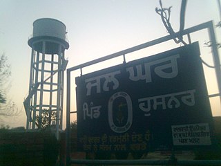
Husnar is a village located in the Giddarbaha tehsil of Sri Muktsar Sahib district in Punjab, India. Most of the population is educated in this village.

Sikhwala is a village in the Malout Tehsil of Sri Muktsar Sahib district in Punjab, India.
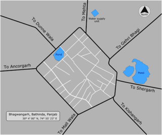
Bhagwangarh, also known as Bhukhianwali is a village of Talwandi Sabo tehsil of Bathinda district of Indian Panjab.
Ramgarh is a medium size village in Phillaur tehsil of Jalandhar District of Punjab State, India. It is located 1 km away from postal head office Phillaur, 16 km from Ludhiana, 45 km from district headquarter Jalandhar and 118 km from state capital Chandigarh. The village is administrated by a sarpanch who is an elected representative of village as per Panchayati raj (India).
Kutbewal is a village in Jalandhar district of Punjab State, India. It is located 4 km away from postal head office in Goraya, 14.2 km from Nurmahal, 40.4 km from district headquarter Jalandhar and 122 km from state capital Chandigarh. The village is administrated by a sarpanch, who is an elected representative.
Bagoran also spelled as Baghoran is a village in Shaheed Bhagat Singh Nagar district of Punjab State, India. It is located 2.7 kilometres (1.7 mi) away from postal head office Mukandpur, 11.2 kilometres (7.0 mi) from Banga, 16.8 kilometres (10.4 mi) from district headquarter Shaheed Bhagat Singh Nagar and 92.5 kilometres (57.5 mi) from state capital Chandigarh. The village is administrated by Sarpanch an elected representative of the village.
Jindowal is a village in Shaheed Bhagat Singh Nagar district of Punjab State, India. It is located 1.6 kilometres (0.99 mi) away postal head office Banga, 15 kilometres (9.3 mi) from Garhshankar, 12 kilometres (7.5 mi) from district headquarter Shaheed Bhagat Singh Nagar and 103 kilometres (64 mi) from state capital Chandigarh. The village is administrated by Sarpanch an elected representative of the village.
Kahlon is a village in Shaheed Bhagat Singh Nagar district of Punjab State, India. It is located 3.8 kilometres (2.4 mi) away from postal head office Rahon, 11 kilometres (6.8 mi) from Nawanshahr, 12.7 kilometres (7.9 mi) from district headquarter Shaheed Bhagat Singh Nagar and 92.7 kilometres (57.6 mi) from state capital Chandigarh. The village is administrated by Sarpanch an elected representative of the village.
Mandi is a village and municipality in Poonch district of the Indian union territory of Jammu and Kashmir. The town is located 20 km (12 mi) from the district headquarters Poonch.

