Lands of Blacklaw

Last updated

Lands of Blacklaw
Black Law Motte and stream, Blacklawhill, East Ayrshire, Scotland.jpg
Blacklaw Mound or Motte
East Ayrshire UK location map.svg
Red pog.svg
Lands of Blacklaw
Location within East Ayrshire
OS grid reference NS466496
Council area
Lieutenancy area
Country Scotland
Sovereign state United Kingdom
Post town Glasgow
Postcode district Neilston
Police Scotland
Fire Scottish
Ambulance Scottish
List of places
UK
Scotland
55°42′54″N4°26′35″W / 55.715°N 4.443°W / 55.715; -4.443 Coordinates: 55°42′54″N4°26′35″W / 55.715°N 4.443°W / 55.715; -4.443

The Lands of Blacklaw formed a small property of five merks worth, in the Lordship of Stewarton at the eastern extremity of Strathannick, between the hamlet of Kingsford in East Ayrshire and the East Renfrewshire boundary, Scotland. It was first recorded in 1484 in the Acta Auditorum. [1] Black Law is a prominent whinstone crag lying above Blacklaw Hill Farm. [2]

Contents

History

The Estate and farms

Datestone on the Old Blacklaw Bridge. Old Blacklaw Bridge datestone.jpg
Datestone on the Old Blacklaw Bridge.

Timothy Pont described the property in the early 17th century as "A pretty extensive range of land, now divided into several farms bearing the names of "Blacklaw", one of which is distinguished as Blacklaw-hill. It is situated in the north-east extremity of the parish of Stewarton, on the confines of Renfrewshire." [1]

A prominent feature is described as "On the farm called Blacklaw-hill is a mount, or small hill, of a conical shape, covered with a beautiful verdure, at the base of which are to be found some fine old trees, indicating the site of a Mansion in former times." [1]

In 1820 the lands of Whitelaw and Blacklaw amounted to 700 acres and the proprietors "live also together in townships". [3] The valued rent of the three properties at Blacklaw were William Gray at £62; John Brown at £62 and Thomas Wallace at £52. [4]

Black Law has had a number of whinstone quarries for local use, such as the steadings, drystone dykes and the Old Blacklaw Bridge. A track led up from Blacklaw Hill Farm to the site. [2]

Laird's house

The old tower castle of Roughwood near Beith. Roughwood Tower.jpg
The old tower castle of Roughwood near Beith.

A prominent feature is described by Timothy Pont in the early 17th century "On the farm called Blacklaw-hill is a mount, or small hill, of a conical shape, covered with a beautiful verdure, at the base of which are to be found some fine old trees, indicating the site of a Mansion in former times." [1] The small conical hill remains in situ, much as described here. Given the early seventeenth century date of Pont's survey any previous mansion house would date from the time where buildings would have some form of defensive fortification as in a typical Scottish tower castle. The site was once surrounded by a drystone dyke, possibly recycling stone from an old building, to exclude grazing animals and a few old beech trees remain.

The conical hill is not listed as a site of archaeological interest and appears never to have been surveyed or excavated, so no information exists as to whether it is entirely natural and if it was used as a motte, a defensive site of some sort or as a Moot Hill, Court Hill or Gallows Hill. The Lands of Blacklaw were part of the Lordship of Stewarton in 1484 [1] and in 1685 the lands are referred to as a 'Lairdship', [5] defined as "A barony or lordship; from an early date, the estate or territory under the jurisdiction of a laird or small baron or freeholder." [6] A Laird's dwelling would have been one of the Blacklaw dwellings. The lands passed into the hands of the Cunninghames of Corshill until they were granted to John Brown in Gabrochhill in 1687. [7]

Old Blacklaw Bridge

The Old Blacklaw Bridge across the Annick Water Old Blacklaw Bridge and the Annick Water - dowstream side view.jpg
The Old Blacklaw Bridge across the Annick Water

The Annick Water lies to the south of the lands of Blacklaw with a bridge (NS465494) carrying a datestone on the upstream side with the initials 'I.Brown' and the dates 1770 and 1881 implying construction and later renovation although the style, execution and weathering of the carving on soft sandstone suggests that the dates, etc. are contemporary with each other and therefore the actual carving is no older than 1818. The 'I' stands for Iohannes which is now written as 'John' and the surname indicated the Brown family, originally of Gabrochhill where they had resided for many generations. [1] The date '1770' has an odd first numeral shaped almost as a 'J'. The bridge is constructed of whinstone, wide enough for horse-drawn vehicles and has mostly lost its low side walls. The datestone is not located as a keystone on the arch of the bridge and therefore could have been inserted at any time, in addition, as stated, it is made of red sandstone.

The head waters of the Annick Water are comparatively shallow and, even in winter, a ford might have sufficed. Blacklaw farm tenants are shown to have had fields here as indicated by the field boundaries marked on Roy's map of 1747 [8] and a track leads up on to Glenouther Moor [2] where the common grazings were located and peats may have been dug. The same map shows a sheep ree on a field boundary, used as a permanent stone sheep-pen where sheep could be confined during poor weather, for shearing, etc.

The Blacklaw Lairds, tenants, etc.

Robert Aitken's 1829 map of Blacklaw and the surrounding farms. Upper Strathannick, Stewarton. Robert Aitken 1829.jpg
Robert Aitken's 1829 map of Blacklaw and the surrounding farms.

In 1484 the tak of the three merks worth lands of Cockilbie and the five merks worth lands of Blacklaw were in dispute and a special writ by the king awarded the tak to "Dauid Lindissa and his spous the wif of umquhile Jenkin Stewart". [1] David Lindsay's dispute was with John Ross of Montgreenan. [9]

The 10 merk land of Blacklaw and Blacklawhill passed into the hands of the Cunninghames of Corshill and on 23 September 1687 Sir Alexander Cuninghame and his mother, Lady Corshill, Dame Mary Stewart, granted a charter of the 2.5 merk land of Blacklawhill to John Brown in Gabrochill (sic). Dobie comments that all the eldest sons were called John, not commonplace outside of the aristocracy. [7]

This John married Elizabeth Brown and had five offspring, John, the eldest. inheriting and marrying Jean Allison of Milton, East Kilbride and having four offspring. [1] Their eldest son John inherited and married Janet Cuthbertson of Carswell, Neilston. They had seven offspring and the eldest, John, inherited in 1750, marrying Grizel Mitchel of Langreen, Loudoun parish. In 1778 their only son John inherited, marrying Elizabeth Deans of Peacockbank and having six children, followed by a second marriage to Margaret Gray of Irvine and the couple having three children. John, the eldest, inherited in 1846 and married Mary Kerr of Stewarton. The couple had offspring, John, William, Andrew, James and four daughters. [7]

The Annick Water looking downstream from the bridge. Annick Water below Old Blacklaw Bridge, Strathannick.jpg
The Annick Water looking downstream from the bridge.

In 1747 Jean, only daughter of John Brown of Blacklawhill married William Mackie of Fulwood and Easter-house of Corshill. [10]

John Brown of Gabrochhill's only daughter, Mary, married Mathew Arnot Stewart, representing the Stewarts of Newton and the Arnots of Lochridge. He died in 1796 and his son Mathew (sic) succeeded him. [11]

The court book of the Barony of Corshill and Cocklbee in 1666 lists the occupiers of the Lands of Blacklaw as William Fultoune (thair); Alexander Fultoune; Alexander Thomsoune; Robert Faullis; Robert Walker; James Faullis and Robert Waker. [12]

In May 1685 the tenants of the lairdship beneath the Black Law were pursued by the Barony Court for "cutting of young root grown trees within the parkes of Corshill" [5]

In December 1701 John Brown and Robert Faullis of Blacklaw were requested by the Barony Court judge to assess how many swine could be grazed on the common pasturage of Hareshaw and Corshouse. They were to assess also which of the two farmers involved suffered most by the overgrazing by the other. [13]

In May 1707 Sir Alexander Cunninghame of Corshill claimed against Janet Thomsone, John Brown and Andrew Faullis of Blacklaw at the Barony court for continuing to eat and destroy "the wast grassis of the maillen of Blacklaw". They were instructed to cease eating "the said wast grass with bestial, goodes, and gear" immediately and informed that the "bestial, goodes, and gear" would be "poyndit", that is confiscated and possibly sold if found breaking this sentence of the court. Despite being warned and informed the defenders did not attend the court held in Stewarton. [14]

The Ayrshire Ordnance Survey name book of 1855 to 1857 records Midtown of Blacklaw as a" farmhouse with outbuildings garden etc. the property of Dr. Brown Stewarton"; Townhead of Blacklaw as a "farmhouse with outbuildings garden - the property of Allen Brown Esqr. Brom"; Lowtown of Blacklaw as a "farmhouse with extensive outbuildings etc. The property of Mr. Thomas Wallace - Stewarton" and Blacklawhall aka Blacklawhill as a "neat farmhouse with very extensive outbuildings, the property of the Occupier Mr. J. Brown." [15]

The Moor of Machirnock (Glenouther)

The old sheep ree, field boundary and Glenouther Moor. Sheep ree and old wall from Old Blacklaw Bridge, Strathannick.jpg
The old sheep ree, field boundary and Glenouther Moor.

This was a very large and valuable area of common grazing immediately to the south of Blacklaw, then known as Machirnock or Maucharnock, [16] now known as Glenouther Moor. The Cunningham and Mure families were often in dispute over their rights regarding grazing, etc. and a royal letter of 1534 states that the Cunninghams had not been invested in the moor and it was decided that the souming was split between Polkelly and Rowallan. [17]

The souming was the number or proportion of cattle which each tenant was entitled to keep on the common grazing. [18] In 1594 William Mure of Rowallan complained of the excess of Polkelly's grazing cattle and geese on the moor, despite having obtained a caution of lawburrows on May 20, 1593. Lawburrows was a letter in the monarch's name under the signet seal to the effect that a particular person had shown cause to dread harm from another, and that therefore this other complained of was commanded to find "sufficient caution and surety" that the complainer would be free from any violence on his part. [19]

The Barony Court records show that some local farms had access to the common grazing and that may have included the Blacklaw farms. [13]

The Robertland Estate was put up for sale in 1913, consisting of 2,243 acres (9.08 km2), with 71 acres (290,000 m2) as woodland and 168 acres (0.68 km2) as moss, 26 farms were present and shooting rights were held for Glenouther Moor. The moor is now mainly afforested with pine trees.

Cartographic evidence

Roy's map of 1747 shows a well laid out grouping of three dwellings below Blacklaw Hill and Blacklaw Townhead above to the north-east. Corshouse and Hareshaw farms lay on the Glenouther Moor side of the Annick Water. [8] In 1856 Blacklawhill, Lowtown of Blacklaw and Midtown of Blacklaw are shown with Townhead of Blacklaw to the north-east. A Blacklaw Cottage stands on the driveway to Blacklawhill. [20] In 1895 a track ran up to the Glenouther Moor crossing the Annock Water by a bridge. A sheep ree is shown on a field boundary below the moor edge. [2]

See also

Related Research Articles

<span class="mw-page-title-main">Barony and Castle of Corsehill</span> Barony in East Ayrshire, Scotland

The old Barony and castle of Corsehill lay within the feudal Baillerie of Cunninghame, near Stewarton, now East Ayrshire, Scotland.
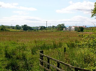
<span class="mw-page-title-main">Hessilhead</span> Area in North Ayrshire, Scotland

Hessilhead is in Beith, North Ayrshire, Scotland. Hessilhead used to be called Hazlehead or Hasslehead. The lands were part of the Lordship of Giffen, and the Barony of Hessilhead, within the Baillerie of Cunninghame and the Parish of Beith. The castle was situated at grid reference NS380532.

The hamlet of Auchentiber is in North Ayrshire, Parish of Kilwinning, Scotland. Auchentiber is four miles northeast of Kilwinning on the Lochlibo Road, 2+14 mi (3.5 km) from the hamlet of Burnhouse and 2+12 mi (4 km) from the village of Barrmill. Grid Ref. NS3647. Some new housing has been built, but the settlement is still very much a hamlet. The settlement is on the Lugton Water, which runs into the River Garnock after running through Montgreenan and Eglinton Country Park in Irvine.

<span class="mw-page-title-main">Barony and Castle of Giffen</span> Barony in the former District of Cunninghame, now North Ayrshire

The Barony of Giffen and its associated 15th-century castle were in the parish of Beith in the former District of Cunninghame, now North Ayrshire. The site may be spelled Giffen or Giffin and lay within the Lordship of Giffin, which included the Baronies of Giffen, Trearne, Hessilhead, Broadstone, Roughwood and Ramshead; valued at £3,788 9s 10d. The Barony of Giffen comprised a number of properties, including Greenhills, Thirdpart, Drumbuie, Nettlehirst and Balgray, covering about half of the parish of Beith. Giffen was a hundred merk land, separated from the Barony of Beith, a forty-pound land, by the Powgree Burn which rises on Cuff hill. The Lugton Water or the Bungle Burn running through Burnhouse may have been the Giffen barony boundary with that of the adjacent barony and lands of Aiket castle.

<span class="mw-page-title-main">Cleeves Cove</span>

Cleeves Cove or Blair Cove is a solutional cave system on the Dusk Water in North Ayrshire, Scotland, close to the town of Dalry.

<span class="mw-page-title-main">Lugton Water</span> River in Scotland

The Lugton Water, the largest tributary of the River Garnock, runs 14 miles (23 km) from Loch Libo in Uplawmoor, through Lugton and the parishes of Neilston, Beith, Dunlop, Stewarton and Kilwinning. The Lugton joins the Garnock below the tidal limit, shortly after passing through Eglinton Country Park, developed around the ancient estate of the Earl of Eglinton.

<span class="mw-page-title-main">Kilmaurs Castle</span>

Kilmaurs Castle was located on the lands of Jocksthorn Farm, near Kilmaurs in East Ayrshire, Scotland. It is described by Timothy Pont in the early 17th century as "Ye castell is ane ancient ftronge building belonging to ye Earls of Glencairne environed with a fair park called Carmell wod from ye vatter of Carmell yat runs by it." Dobie goes on to state that "The old baronial manor place is supposed to have been situated about a mile south-east of Kilmaurs, where some ruins can still be pointed out on the farm of Jakisthorn or Jock's-thorn, probably the original Villam de Cuninghame - the first possession of the family." The castle is not to be confused with the later Cunninghame family possession known as Kilmaurs Place which Dobie calls "..comparatively modern" in 1876.

The Barony of Peacockbank was in the old feudal Baillerie of Cunninghame, near Stewarton in what is now East Ayrshire, Scotland.

<span class="mw-page-title-main">Barony of Bonshaw</span> Barony in North Ayrshire, Scotland

The Barony of Bonshaw, previously known as Bollingshaw, was in the old feudal Baillerie of Cunninghame, near Stewarton in what is now North Ayrshire, Scotland.

<span class="mw-page-title-main">Caldwell, East Renfrewshire</span>

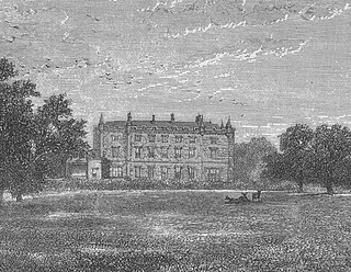
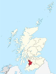
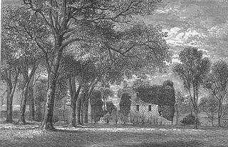
Caldwell is a mansion and old estate with the remains of a castle nearby. These lands lie close to the Lugton Water and the villages of Uplawmoor in East Renfrewshire and Lugton in East Ayrshire.

<span class="mw-page-title-main">Giffordland</span> Barony in North Ayrshire, United Kingdom

Giffordland is in North Ayrshire, Parish of Dalry (Cunninghame) in the former Region of Strathclyde, Scotland.

<span class="mw-page-title-main">Castle and Barony of Robertland</span>

The Castle and Barony of Robertland is located near Stewarton, off the B769 road, in the old district of Cunninghame, Parish of Stewarton, and now part of East Ayrshire, Scotland.

<span class="mw-page-title-main">Kirkwood Estate, East Ayrshire</span>

The Lands of Kirkwood (NS3947) formed a small estate in the Parish of Stewarton, East Ayrshire lying between Stewarton and Dunlop, which in 1678 became part of the lands of Lainshaw, known as the Lainshaw, Kirkwood and Bridgehouse Estate. Kirkwood was anciently known as Bloak Cunninghame. Kirkwood remains as a farm in 2010.

<span class="mw-page-title-main">Halket Loch</span> Body of water

Halket Loch' also known as Halkhead or Halketh, was situated in the mid-Ayrshire clayland near Lugton. It is visible as a surface depression in pastureland, sometimes partially flooded, situated in a low-lying area close to farms and dwellings of East, North and Middle Halket and Craighead in the Parish of Dunlop, East Ayrshire, Scotland. The loch was natural, sitting in a hollow created by glaciation. The loch waters drained via the Glazert Water that joins the Annick Water.

<span class="mw-page-title-main">Polkelly Castle</span>

Polkelly Castle, also Pokelly, was an ancient castle located near Fenwick, at NS 4568 4524, in the medieval free Barony of Polkelly, lying north of Kilmarnock, Parish of Fenwick, East Ayrshire, Scotland. The castle is recorded as Powkelly (c1747), Pockelly (c1775), Pow-Kaillie, Ponekell, Polnekel, Pollockelly, Pollockellie, Pokellie, Pothelly, Pathelly Ha' and Polkelly. The name is given circa 1564 as Powkellie when it was held by the Cunninghams of Cunninghamhead.

The Lands of Cocklebie or Cocklebee formed an estate possessing a common border with the estates of Lainshaw, the Corsehill, and the town of Stewarton, East Ayrshire, Parish of Stewarton, Scotland.

<span class="mw-page-title-main">Kingsford, East Ayrshire</span> Human settlement in Scotland

Kingsford is a hamlet or clachan in Strathannick, East Ayrshire, parish of Stewarton, Scotland. The habitation is situated on the B769, two miles north of Stewarton and fourteen miles from Glasgow.

<span class="mw-page-title-main">Fairlie Castle</span>

Fairlie Castle is a restored oblong tower castle located on a natural rounded knoll situated above a precipitous section of the Fairlie Glen near the town of Fairlie in the old Barony of Fairlie, Parish of Largs, North Ayrshire, Scotland. It was built by the now extinct family, the Fairlies of that Ilk and survives in a fairly good state of preservation. It is a protected scheduled monument.

<span class="mw-page-title-main">Lands of Borland</span> Human settlement in Scotland

The Lands of Borland formed an estate lying between Aiket Castle and the town of Dunlop, East Ayrshire, Parish of Dunlop, Scotland. The laird's house at Borland stood near the Sandy Ford over the Glazert Water. The names Bordland, Boreland, Borland, Laigh Borland, Low Borland and Nether Borland have all been applied to the site of the laird's house.

<span class="mw-page-title-main">Lands of Templehouse</span> Human settlement in Scotland

The Lands of Templehouse formed a small estate lying between Aiket Castle and the town of Dunlop, East Ayrshire, Parish of Dunlop, Scotland. The laird's house at Templeland of Dunlop Hill, to give it its formal name, stood near to the ancient road leading from Dunlop to Kirkwood and on to Kennox. The lands were held by the Knights Templar until a date prior to 1570 when the Gemmells of Templehouse were granted the property and remained there until 1962, a period of around 500 years. The spelling 'Gemmell' is used for consistency except where otherwise denoted.

References

Notes
  1. 1 2 3 4 5 6 7 8 Dobie, James (1876). Cunninghame, Topographized by Timothy Pont 1604–1608, with continuations and illustrative notices. John Tweed. p. 99.
  2. 1 2 3 4 Renfrewshire XVIII.6, Revised: 1895, Published: 1897
  3. Robertson, George (1820). Topographical Description of Ayrshire more particularly in Cunninghame. Cunninghame Press. p. 324.
  4. Robertson, George (1820). Topographical Description of Ayrshire more particularly in Cunninghame. Cunninghame Press. p. 327.
  5. 1 2 Shedden-Dobie, John (1884). Corshill Baron-Court Book. Vol. iv. Ayr and Wigton Archaeological Association. p. 169.
  6. Dictionary of Scots
  7. 1 2 3 Dobie, James (1876). Cunninghame, Topographized by Timothy Pont 1604–1608, with continuations and illustrative notices. John Tweed. p. 100.
  8. 1 2 Roy Lowlands 1752-55
  9. Dobie, James (1876). Cunninghame, Topographized by Timothy Pont 1604–1608, with continuations and illustrative notices. John Tweed. p. 333.
  10. Dobie, James (1876). Cunninghame, Topographized by Timothy Pont 1604–1608, with continuations and illustrative notices. John Tweed. p. 138.
  11. Robertson, George (1823). A Genealogical Account of the Principal Families in Ayrshire more particularly of Cunninghame. Cunninghame Press. p. 21.
  12. Shedden-Dobie, John (1884). Corshill Baron-Court Book. Vol. iv. Ayr and Wigton Archaeological Association. p. 68.
  13. 1 2 Shedden-Dobie, John (1884). Corshill Baron-Court Book. Vol. iv. Ayr and Wigton Archaeological Association. p. 186.
  14. Shedden-Dobie, John (1884). Corshill Baron-Court Book. Vol. iv. Ayr and Wigton Archaeological Association. p. 226.
  15. Ayr Ordnance Survey Name Book. 1855-1857.
  16. Moll, Herman, d. 1732. The Shire of Renfrew with Cuningham [i.e. Cunningham]. The North Part of Air [i.e. Ayr] / by H. Moll.
  17. Ewart, Gordon (2009). A Palace fit for a Laird. Rowallan Castle. Archaeological and Research 1998-2008. Historic Scotland. Historic Scotland. p. 95. ISBN   978-1-84917-015-4.
  18. Researcher's Guide Retrieved : 2011-06-10
  19. Researcher;s Guide Retrieved : 2011-06-10
  20. Renfrewshire, Sheet XVIII, Surveyed: 1856, Published: 1863
Sources and Bibliography
  1. Archaeological & Historical Collections relating to Ayr & Wigton. 1884. Vol. IV. Shedden-Dobie, John. The Church of Dunlop.
  2. Davis, Michael C. (1991). The Castles and Mansions of Ayrshire. Privately Published.
  3. Dobie, James D. (ed Dobie, J.S.) (1876). Cunninghame, Topographized by Timothy Pont 1604–1608, with continuations and illustrative notices. Glasgow: John Tweed.
  4. Fullarton, John (1864). Historical Memoir of the family of Eglinton and Winton. Ardrossan : Arthur Guthrie.
  5. Johnston, J. B. (1903). Place-names of Scotland. Edinburgh : David Douglas.
  6. Mackenzie, W. Mackay (1927). The Medieval Castle in Scotland. Pub. Methuen & Co. Ltd.
  7. MacIntosh, John (1894). Ayrshire Nights Entertainments: A Descriptive Guide to the History, Traditions, Antiquities, etc. of the County of Ayr. Pub. Kilmarnock.
  8. McMichael, George (c. 1881 - 1890). Notes on the Way Through Ayrshire and the Land of Burn, Wallace, Henry the Minstrel, and Covenant Martyrs. Hugh Henry : Ayr.
  9. Ness, John (1990). Kilwinning Encyclopedia. Kilwinning & District Preservation Society.
  10. Paterson, James (1863–66). History of the Counties of Ayr and Wigton. V. - IV - Cunninghame. Part 1. Edinburgh : J. Stillie.