Laurel, Nebraska

Last updated

Laurel, Nebraska
Laurel, Nebraska 2nd St E from Elm St.JPG
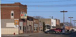
Downtown Laurel looking east from 2nd and Elm St. prior to the Downtown Revitalization Project finished in 2021.
Cedar County Nebraska Incorporated and Unincorporated areas Laurel Highlighted.svg
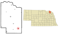
Location of Laurel, Nebraska
Coordinates: 42°25′44″N97°05′49″W / 42.42889°N 97.09694°W / 42.42889; -97.09694
Country United States
State Nebraska
County Cedar
Government
  MayorKeith Knudsen [1]
Area
[2]
  Total1.35 sq mi (3.50 km2)
  Land1.35 sq mi (3.50 km2)
  Water0.00 sq mi (0.00 km2)
Elevation
[3]
1,493 ft (455 m)
Population
 (2020) [4]
  Total975
  Estimate 
(2021) [4]
968
  Density718.40/sq mi (277.37/km2)
Time zone UTC-6 (Central (CST))
  Summer (DST) UTC-5 (CDT)
ZIP code
68745
Area code 402
FIPS code 31-26350 [5]
GNIS feature ID2395644 [3]
Website Official City website

Laurel is a city in Cedar County, Nebraska located at the merger of Highway 20 and Highway 15 in the northeast corner of the state. Laurel sits roughly 40 miles east of Norfolk, Nebraska, west of Sioux City, Iowa, and south of Yankton, South Dakota. Wayne State College in Wayne, Nebraska is 15 miles south of Laurel. Its population was 975 at the 2020 census. [4]

Contents

History

Laurel was founded in 1893 and was originally named Claremont Junction. The present name is after Laura Martin, the daughter of one of the city's founders.

In 2021 the city completed its last phase of a $2.6 million Downtown Revitalization Project which included removing the median from and pouring new concrete on East 2nd (Main) Street, widening the downtown sidewalks, and constructing a new city hall which houses the city offices, senior center, and can be used for parties and events.

Also in 2021 the city opened its new fire hall in thanks to fundraising and donations. The new fire hall holds up to seven fire engines, two ambulances, and has storage, a classroom, and common area spaces. The volunteer fire department and EMS are housed out of the hall.

The city is currently constructing a new school which will be attached to part of the existing school. Once the new addition is complete, the existing structure will receive renovations and updates. This is part of a $25 million bond that passed in 2021 by a single vote, 596–595.

Schools

Laurel is located within the Laurel-Concord-Coleridge School District. [6] Currently the Elementary and High School are based in Laurel. Their mascot is the Bears.

Churches

Laurel is served by four community churches:

As well as two churches in nearby Concord, Nebraska:

Demographics

Historical population
CensusPop.Note
1900 514
1910 5140.0%
1920 83061.5%
1930 8644.1%
1940 861−0.3%
1950 9449.6%
1960 922−2.3%
1970 1,0099.4%
1980 1,0312.2%
1990 981−4.8%
2000 9860.5%
2010 964−2.2%
2020 9751.1%
U.S. Decennial Census [4]

2010 census

At the 2010 census, 964 people in 415 households, including 263 families, lived in the city. The population density was 983.7 inhabitants per square mile (379.8/km2). The 474 housing units had an average density of 483.7 units per square mile (186.8 units/km2). The racial makeup of the city was 96.8% White, 0.2% African American, 0.2% Native American, 0.3% Asian, 1.2% from other races, and 1.2% from two or more races. Hispanics or Latinos of any race were 2.4%. [7]

Of the 415 households, 26.3% had children under 18 living with them, 56.4% were married couples living together, 5.3% had a female householder with no husband present, 1.7% had a male householder with no wife present, and 36.6% were not families. About 33.5% of households were one person and 16.4% were one person aged 65 or older. The average household size was 2.26, and the average family size was 2.90.

The median age was 44.7 years; 22.6% of residents were under 18; 6.4% were between 18 and 24; 21.3% were from 25 to 44; 25% were from 45 to 64; and 24.7% were 65 or older. The gender makeup of the city was 48.0% male and 52.0% female.

2000 census

At the 2000 census, 986 people in 414 households, including 264 families, were in the city. The population density was 1,072.5 inhabitants per square mile (414.1/km2). The 466 housing units had an average density of 506.9 units per square mile (195.7 units/km2). The racial makeup of the city was 99.49% White, 0.20% Native American, 0.10% Pacific Islander, 0.10% from other races, and 0.10% from two or more races. Hispanics or Latinos of any race were 0.30%. [5]

Of the 414 households, 26.3% had children under 18 living with them, 56.3% were married couples living together, 6.3% had a female householder with no husband present, and 36.0% were not families. About 32.9% of households were one person, and 22.9% were one person 65 or older. The average household size was 2.28, and the average family size was 2.91.

The age distribution was 23.3% under 18, 6.3% from 18 to 24, 20.4% from 25 to 44, 19.8% from 45 to 64, and 30.2% 65 or older. The median age was 45 years. For every 100 females, there were 85.0 males. For every 100 females 18 and over, there were 79.1 males.

The median household income was $29,722, and for a family was $35,662. Males had a median income of $26,731 versus $20,833 for females. The per capita income for the city was $16,500. About 6.0% of families and 8.4% of the population were below the poverty line, including 10.0% of those under age 18 and 7.2% of those age 65 or over.
Notable people

Related Research Articles

<span class="mw-page-title-main">Saint Joe, Indiana</span> Place in Indiana, United States

Saint Joe is a town in Concord Township, DeKalb County, Indiana, United States. The population was 460 at the 2010 census.

<span class="mw-page-title-main">Bangor, Michigan</span> City in Michigan, United States

Bangor is a city in Van Buren County in the U.S. state of Michigan. The population was 1,885 at the 2010 census. The city is located in the northeast corner of Bangor Township, but is politically independent.

<span class="mw-page-title-main">Lewiston, Minnesota</span> City in Minnesota, United States

Lewiston is a city in Winona County, Minnesota, United States. The population was 1,620 at the 2010 census.

<span class="mw-page-title-main">Coleridge, Nebraska</span> Village in Nebraska, United States

Coleridge is a village in Cedar County, Nebraska, United States. The population was 537 at the 2020 census.

<span class="mw-page-title-main">Sutton, Nebraska</span> City in Nebraska, United States

Sutton is a city in Clay County, Nebraska, United States. The population was 1,447 at the 2020 census. It is part of the Hastings, Nebraska Micropolitan Statistical Area.

<span class="mw-page-title-main">Dakota City, Nebraska</span> City in Dakota County, Nebraska, United States

Dakota City is a city in Dakota County, Nebraska, United States. The population was 1,919 at the 2010 census. It is the county seat of Dakota County. Tyson Foods' largest beef production plant is located in Dakota City.

<span class="mw-page-title-main">Concord, Nebraska</span> Village in Dixon County, Nebraska, United States

Concord is a village in Dixon County, Nebraska, United States. It is part of the Sioux City, IA–NE–SD Metropolitan Statistical Area. The population was 166 at the 2010 census.

<span class="mw-page-title-main">Geneva, Nebraska</span> City in Nebraska, United States

Geneva is a city in, and the county seat of, Fillmore County, Nebraska, United States. The population was 2,217 at the 2010 census.

<span class="mw-page-title-main">Daykin, Nebraska</span> Village in Nebraska, United States

Daykin is a village in Jefferson County, Nebraska, United States. The population was 157 at the 2020 census.

<span class="mw-page-title-main">Axtell, Nebraska</span> Village in Nebraska, United States

Axtell is a village in western Kearney County, Nebraska, United States. It is part of the Kearney, Nebraska Micropolitan Statistical Area. The population was 732 at the 2020 census.

<span class="mw-page-title-main">Ogallala, Nebraska</span> City in Nebraska, United States

Ogallala is a city in and the county seat of Keith County, Nebraska, United States. The population was 4,878 at the 2020 census, up from 4,737 at the 2010 census. In the days of the Nebraska Territory, the city was a stop on the Pony Express and later along the transcontinental railroad. The Ogallala Formation that carries the Ogallala Aquifer was named after the city.

<span class="mw-page-title-main">Seward, Nebraska</span> City in and county seat of Seward County, Nebraska, United States

Seward is a city and county seat of Seward County, Nebraska, United States. The population was 7,643 at the 2020 census. Seward is part of the Lincoln, Nebraska Metropolitan Statistical Area.

<span class="mw-page-title-main">Davenport, Nebraska</span> Village in Thayer County, Nebraska, United States

Davenport is a village in Thayer County, Nebraska, United States. The population was 321 at the 2020 census.

<span class="mw-page-title-main">Blair, Nebraska</span> City in and county seat of Washington County, Nebraska, United States

Blair is a city in and the county seat of Washington County, Nebraska, United States. The population was 7,990 at the 2010 census. Blair is a part of the Omaha-Council Bluffs Metropolitan Statistical Area.

<span class="mw-page-title-main">Fort Calhoun, Nebraska</span> City in Washington County, Nebraska, United States

Fort Calhoun is a city in Washington County, Nebraska, United States. The population was 1,108 at the 2020 census. The city includes Fort Atkinson, the first fort built west of the Missouri River.

<span class="mw-page-title-main">Hoskins, Nebraska</span> Village in Wayne County, Nebraska, United States

Hoskins is a village in Wayne County, Nebraska, United States. The population was 267 at the 2020 census.

<span class="mw-page-title-main">Waco, Nebraska</span> Village in York County, Nebraska, United States

Waco is a village in York County, Nebraska, United States. The population was 236 at the 2010 census.

<span class="mw-page-title-main">York, Nebraska</span> City in and county seat of York County, Nebraska, United States

York is a city in and the county seat of York County, Nebraska, United States. At the 2010 census, the city population was 7,766. It is the home of York University and the Nebraska Correctional Center for Women.

<span class="mw-page-title-main">Athens, West Virginia</span> Town in West Virginia, United States

Athens is a town in Mercer County, West Virginia, United States. The population was 944 at the 2020 census. It is part of the Bluefield, WV-VA micropolitan area which has a population of 107,578. Athens is the home of Concord University.

<span class="mw-page-title-main">Newman Grove, Nebraska</span> City in Platte County, Nebraska, United States

Newman Grove is a city in Madison and Platte counties in Nebraska, United States. The population was 667 at the 2020 census.

References

  1. "Contact Us / Government".
  2. "ArcGIS REST Services Directory". United States Census Bureau. Retrieved September 18, 2022.
  3. 1 2 U.S. Geological Survey Geographic Names Information System: Laurel, Nebraska
  4. 1 2 3 4 Bureau, US Census. "City and Town Population Totals: 2020-2021". Census.gov. US Census Bureau. Retrieved January 25, 2023.
  5. 1 2 "U.S. Census website". United States Census Bureau . Retrieved January 31, 2008.
  6. "Laurel Concord Coleridge Public School". www.lccschool.org.
  7. "U.S. Census website". United States Census Bureau . Retrieved June 24, 2012.