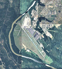
Lawson Army Airfield

Last updated
Lawson Army Airfield (Fort Moore)
Lawson Army Airfield - Georgia.jpg
2006 USGS airphoto
Summary
Airport typeMilitary
Owner United States Army
Location Fort Moore
Columbus, Georgia
Elevation  AMSL 232 ft / 71 m
Coordinates 32°20′14″N084°59′29″W / 32.33722°N 84.99139°W / 32.33722; -84.99139
Map
USA Georgia location map.svg
Airplane silhouette.svg
KLSF
Location of Lawson Army Airfield
Runways
Direction LengthSurface
ftm
15/3310,0003,048 Asphalt

Lawson Army Airfield( IATA : LSF, ICAO : KLSF, FAA LID : LSF) is a military airport located at Fort Moore (formerly Fort Benning) in Chattahoochee County, Georgia, south of the city of Columbus, Georgia. [1] It is Fort Moore's primary force projection platform.

Contents

Facilities

Lawson Army Airfield has one runway:

History

Origins

In late 1918, the U.S. Army established a new camp for the Infantry School of Arms south of Columbus on the Bussey Plantation. The camp was named in honor of Henry Lewis Benning, a Columbus native who served as a Confederate general during the American Civil War and later as a justice of the Georgia Supreme Court. The Army created a rudimentary landing field at Benning in 1919 with the initial mission of determining if data obtained by balloon observation would benefit the infantry. The airfield consisted of two small hangars that housed the balloon unit.

In 1922, the Army made the facility a permanent Army post renaming the camp Fort Benning. From 1921 to 1931, aircraft from Maxwell Field near Montgomery, Alabama occasionally utilized the airfield for maneuvers and other purposes. In 1928, the balloon unit transferred and the airfield was without any permanent occupation for three years.

In August 1931, the Army named the airfield in honor of Capt. Walter R. Lawson, a Georgia native who had been killed in the crash of a Martin MB-2 at McCook Field, Ohio on 21 April 1923. Lawson served with the 41st French Escadrille during World War I, had one victory, and received the Distinguished Flying Cross for heroism in action. The same year, Flight B of Ft. Riley, Kansas' 16th Observation Squadron, consisting of five officers and 35 enlisted men, moved to Lawson. Flight B operated three Douglas 0-25 aircraft out of a double hangar. Units from Fort Bragg, North Carolina later joined Flight B. The mission of Flight B involved directing artillery fire and spotting enemy positions during maneuvers.

In 1933, the Army spent $855,060 upgrading Lawson's facilities. On 1 September 1940, Lawson Field separated from the Infantry School and became an Army Airfield under the Commanding General of the Army Air Corps. By the fall of 1940, the 16th Reconnaissance Squadron, the 97th Tactical Reconnaissance Squadron and the 15th Bombardment Squadron (Light) had been transferred to the field.

World War II

During 1941, as the Army Air Corps transitioned to the U.S. Army Air Forces, a major project took place at Lawson with the construction of barracks, runways, parking aprons and other facilities. Several additional observation, reconnaissance, and light bomber squadrons passed through Lawson during 1941 and the first of 1942. The 74th Observation Group (February 27, 1942 – April 10, 1942) Trained personnel in aerial reconnaissance, medium bombardment, and fighter techniques.

The continued growth of parachute training at Lawson led the Army to turn the field over to the I Troop Carrier Command on 26 August 1942. The 316th Troop Carrier Group (TCG) with four C-47 squadrons had already arrived at Lawson on 8 August.

Other Army Air Force Troop Carrier C-47 units assigned to Lawson during World War II were:

For all of the war, a Troop Carrier Group (TCG) was always present at Lawson conducting training and providing aircraft for the Parachute School. In June 1943, the 10th TCG became a Replacement Training Unit in addition to the mission of dropping troopers for the Parachute School. The 3rd Composite Squadron was also present at Lawson from April 1942 to November 1945 with a wide variety of fighter, light bombers, and liaison/observation aircraft to provide aerial support for training by the Infantry School.

Lawson and Ft. Benning had many distinguished visitors during the war including Gen. George C. Marshall, Gen. Hap Arnold, Lord Louis Mountbatten and Anthony Eden, the British Foreign Secretary. When President Franklin Roosevelt visited the base on 15 April 1943, the School conducted a parachute drop for his viewing.

Fort Benning and Lawson Field Fort Benning and Lawson Field - DPLA - 27cd11cb5a8edec81d79bd9bb2631be1.pdf
Fort Benning and Lawson Field

Postwar use

Following the war, Troop Carrier Squadrons remained at Lawson in support of the Parachute School with the C-46. Lawson Air Force Base came into existence in 1947 with the creation of the United States Air Force. Postwar Air Force units assigned were:

In 1954, the Air Force turned Lawson over to the Army, and it has operated continually since that time as Lawson Army Airfield.

Lawson received a major expansion program in 1965 including an 8,200-ft. runway capable of handling large jet transports.

In 1967, Lawson Army Airfield was used for filming as part of the production of The Green Berets (film). It served as a stand-in for Da Nang Air Base, South Vietnam.

Presently Army aviation assets at Lawson support the Infantry School and other units stationed at Fort Moore.

See also

Related Research Articles

<span class="mw-page-title-main">RAF Aldermaston</span> Former Royal Air Force station in Berkshire, England

Royal Air Force Aldermaston, or more simply RAF Aldermaston, is a former Royal Air Force station located 8 miles (13 km) east of Newbury, Berkshire and 9.8 miles (15.8 km) southwest of Reading, Berkshire, England.

<span class="mw-page-title-main">Hunter Army Airfield</span> Military airfield near Hinesville, Georgia, US

Hunter Army Airfield, located in Savannah, Georgia, United States, is a military airfield and subordinate installation to Fort Stewart located in Hinesville, Georgia.

<span class="mw-page-title-main">Alliance Municipal Airport</span> Airport

Alliance Municipal Airport is in Box Butte County, Nebraska, three miles southeast of the city of Alliance, which owns it. Denver Air Connection offers scheduled passenger flights to Denver, which are subsidized by the Essential Air Service program.

<span class="mw-page-title-main">RAF Membury</span> Former RAF base in Berkshire, England

Royal Air Force Membury or more simply RAF Membury is a former Royal Air Force station built in the civil parish of Lambourn in Berkshire, England, approximately 4.6 miles (7.4 km) north-northwest of Hungerford. The airfield was opened on the site of a civil airfield in August 1942, and closed in October 1946.

<span class="mw-page-title-main">Salinas Municipal Airport</span> Municipal airport in Salinas, California, United States

Salinas Municipal Airport, commonly referred to as Salinas Airport is an airport in Monterey County, California, United States, three miles (4.8 km) southeast of Downtown Salinas. It is included in the 2017–21 National Plan of Integrated Airport Systems as a regional general aviation airport. It had 1,800 enplanements in 2014.

<span class="mw-page-title-main">Reading Regional Airport</span> Airport in Pennsylvania

Reading Regional Airport, also known as Carl A. Spaatz Field, is a public airport three miles (5 km) northwest of Reading, in Bern Township, Berks County, Pennsylvania. It is owned by the Reading Regional Airport Authority.

<span class="mw-page-title-main">RAF Spanhoe</span> Former Royal Air Force station in Northamptonshire, England

Royal Air Force Spanhoe or more simply RAF Spanhoe is a former Royal Air Force station near Uppingham in Northamptonshire, England. The airfield is located approximately 4 miles (6.4 km) east of Uppingham; about 80 miles (130 km) north-northwest of London

<span class="mw-page-title-main">Daniel Field</span> Airport

Daniel Field is a public use airport located one nautical mile (2 km) west of the central business district of Augusta, a city in Richmond County, Georgia, United States. It is owned by the City of Augusta and operated by the General Aviation Commission. This airport is included in the National Plan of Integrated Airport Systems for 2021–2025, which categorized it as a general aviation facility.

<span class="mw-page-title-main">Statesboro–Bulloch County Airport</span> Airport in near Statesboro, Georgia

Statesboro–Bulloch County Airport is a public airport located three miles (5 km) northeast of the central business district of Statesboro, a city in Bulloch County, Georgia, United States. It is owned by the City of Statesboro and Bulloch County. Currently, there is no commercial service to the airport.

<span class="mw-page-title-main">Bakalar Air Force Base</span> Former US Air Force base near Columbus, Indiana

Bakalar Air Force Base is a former U.S. Air Force base located 4.4 miles (7.1 km) northeast of Columbus, Indiana. During World War II, the base was known as Atterbury Air Field and Atterbury Army Air Base, but it was renamed Bakalar Air Force Base in 1954 in honor of First Lieutenant John Edmond Bakalar, USAAF. Established in 1942, the airfield served as a training base for medium-range C-46 Commando and C-47 Skytrain troop carrier planes and glider pilots. It also was used for training B-25 Mitchell and B-26 Marauder bomber crews. Reactivated during the Cold War, it was used as an Air Force Reserve training base for troop carrier, tactical airlift, and special operations flying units. The military base was closed in 1970. The present-day facility operates as the Columbus Municipal Airport.

During World War II, the United States Army Air Forces (USAAF) established numerous airfields in Georgia for antisubmarine defense in the Gulf of Mexico and for training pilots and aircrews of USAAF fighters and bombers.

<span class="mw-page-title-main">Scarlett Martínez International Airport</span> Airport in Panama

Scarlett Martínez International Airport, also known as Río Hato Airport, is an international airport serving Río Hato, a town in the Coclé Province of Panama. The airport is 3 kilometres (2 mi) east of Río Hato.

<span class="mw-page-title-main">Thornbrough Air Force Base</span> Airport

Thornbrough Air Force Base is a former facility of the United States Air Force in Cold Bay, Alaska. Following its closure, it was redeveloped into Cold Bay Airport.

<span class="mw-page-title-main">Thomasville Regional Airport</span> Airport

Thomasville Regional Airport is a city-owned, public-use airport located six nautical miles northeast of the central business district of Thomasville, a city in Thomas County, Georgia, United States. It is included in the National Plan of Integrated Airport Systems for 2011–2015, which categorized it as a general aviation facility. The airport does not have scheduled commercial airline service.

<span class="mw-page-title-main">Atlanta Army Air Field</span>

Atlanta Army Air Field is a former United States Army Air Corps training facility that operated on the grounds of the present Hartsfield–Jackson Atlanta International Airport during World War II.

<span class="mw-page-title-main">Laurinburg–Maxton Army Air Base</span> Inactive USAAF base, closed 1945

Laurinburg–Maxton Army Air Base is an inactive United States Air Force base, approximately 6 miles east-northeast of Laurinburg, North Carolina. It was active during World War II as a I Troop Carrier Command training airfield.

Guercif Airfield is an abandoned military airfield in Morocco, located about 4 km northeast of Guercif ; 400 km east-northeast of Casablanca, near the Algerian border.

<span class="mw-page-title-main">Pounds Army Air Field</span>

Pounds Army Air Field is a former United States Army Air Forces airfield, located 6 mi (9.7 km) west of Tyler, Texas. It was established in 1942 and assigned to Third Air Force. Its mission was the training of units, crews, and support individuals prior to their deployment to the combat theaters overseas. It was closed as an active military airfield on 31 January 1945 and was subsequently turned over to local civilian authorities. Today it remains in use by the city of Tyler as Tyler Pounds Regional Airport.

<span class="mw-page-title-main">Aiken Air Force Station</span> Closed United States Air Force General Surveillance Radar station

Aiken Air Force Station is a closed United States Air Force General Surveillance Radar station. It is located 6.4 miles (10.3 km) north-northeast of Aiken, South Carolina. It was closed in 1975.

<span class="mw-page-title-main">303rd Tactical Reconnaissance Squadron</span> Military unit

The 303rd Tactical Reconnaissance Squadron is an inactive United States Air Force unit. It was last assigned to the 66th Tactical Reconnaissance Wing and stationed at Laon-Couvron Air Base, France. The squadron was first activated in January 1953 at Shaw Air Force Base, South Carolina, moving to Europe in July. The squadron performed reconnaissance missions for North Atlantic Treaty Organization from bases in Germany and France until it was inactivated in 1959 and replaced by a squadron flying more advanced aircraft.

References

PD-icon.svg This article incorporates public domain material from the Air Force Historical Research Agency