Related Research Articles

The Ohio River is a 981-mile (1,579 km) long river in the United States. It is located at the boundary of the Midwestern and Southern United States, flowing southwesterly from western Pennsylvania to its mouth on the Mississippi River at the southern tip of Illinois. It is the third largest river by discharge volume in the United States and the largest tributary by volume of the north-south flowing Mississippi River that divides the eastern from western United States. It is also the 6th oldest river on the North American continent. The river flows through or along the border of six states, and its drainage basin includes parts of 14 states. Through its largest tributary, the Tennessee River, the basin includes several states of the southeastern U.S. It is the source of drinking water for five million people.
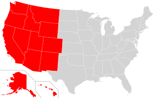
The Western United States is the region comprising the westernmost states of the United States. As American settlement in the U.S. expanded westward, the meaning of the term the West changed. Before about 1800, the crest of the Appalachian Mountains was seen as the western frontier. The frontier moved westward and eventually the lands west of the Mississippi River were considered the West.
The Global 200 is the list of ecoregions identified by the World Wide Fund for Nature (WWF), the global conservation organization, as priorities for conservation. According to WWF, an ecoregion is defined as a "relatively large unit of land or water containing a characteristic set of natural communities that share a large majority of their species dynamics, and environmental conditions". For example, based on their levels of endemism, Madagascar gets multiple listings, ancient Lake Baikal gets one, and the North American Great Lakes get none.

The Intracoastal Waterway (ICW) is a 3,000-mile (4,800 km) inland waterway along the Atlantic and Gulf of Mexico coasts of the United States, running from Massachusetts southward along the Atlantic Seaboard and around the southern tip of Florida, then following the Gulf Coast to Brownsville, Texas. Some sections of the waterway consist of natural inlets, saltwater rivers, bays, and sounds, while others are artificial canals. It provides a navigable route along its length without many of the hazards of travel on the open sea.

The Illinois Country —sometimes referred to as Upper Louisiana —was a vast region of New France claimed in the 1600s in what is now the Midwestern United States. While these names generally referred to the entire Upper Mississippi River watershed, French colonial settlement was concentrated along the Mississippi and Illinois Rivers in what is now the U.S. states of Illinois and Missouri, with outposts in Indiana. Explored in 1673 from Green Bay to the Arkansas River by the Canadien expedition of Louis Jolliet and Jacques Marquette, the area was claimed by France. It was settled primarily from the Pays d'en Haut in the context of the fur trade, and in the establishment of missions by French Catholic religious orders. Over time, the fur trade took some French to the far reaches of the Rocky Mountains, especially along the branches of the broad Missouri River valley. The French name, Pays des Ilinois, means "Land of the Illinois [plural]" and is a reference to the Illinois Confederation, a group of related Algonquian native peoples.

The Florida Panhandle is the northwestern part of the U.S. state of Florida; it is a salient roughly 200 miles (320 km) long and 50 to 100 miles wide, lying between Alabama on the north and the west, Georgia on the north, and the Gulf of Mexico to the south. Its eastern boundary is arbitrarily defined. In terms of population, major communities include Tallahassee, Pensacola, and Panama City.

The Inter-American Division of Seventh-day Adventists is a sub-entity of the General Conference of Seventh-day Adventists, which oversees the Church's work in Mexico, Central America, the Caribbean, and Northern South America.
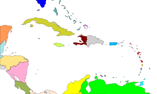
In Geography, the Caribbean Basin is generally defined as the area running from Florida westward along the Gulf coast, then south along the Mexican coast through Central America and then eastward across the northern coast of South America. This region includes the islands of the archipelago of the West Indies. Bermuda is also included within the region even though it is in the west-central Atlantic, due to its common cultural history created by European colonization of the region, and in most of the region by the presence of a significant group of African descent.

The Commonwealth Caribbean is the region of the Caribbean with English-speaking countries and territories, which once constituted the Caribbean portion of the British Empire and are now part of the Commonwealth of Nations. The term includes many independent island nations, British Overseas Territories and some mainland nations. It is also known as the English-speaking Caribbean,Anglophone Caribbean or Anglo-Caribbean. The term is now used in preference over the older term British West Indies, which was used to describe the British colonies in the West Indies during decolonisation and following independence from the United Kingdom. Anglo-Caribbean and British Commonwealth Caribbean also became preferred replacement terms to British West Indies.

The Americas, also known as America, are lands of the Western Hemisphere, composed of numerous entities and regions variably defined by geography, politics, and culture.

The West Indies is a subregion of North America, surrounded by the North Atlantic Ocean and the Caribbean Sea that includes 13 independent island countries and 18 dependencies and other territories in three major archipelagos: the Greater Antilles, the Lesser Antilles, and the Lucayan Archipelago.
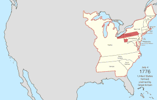
The United States of America was created on July 4, 1776, with the Declaration of Independence of thirteen British colonies in North America. In the Lee Resolution two days prior, the colonies resolved that they were free and independent states. The union was formalized in the Articles of Confederation, which came into force on March 1, 1781, after being ratified by all 13 states. Their independence was recognized by Great Britain in the Treaty of Paris of 1783, which concluded the American Revolutionary War. This effectively doubled the size of the colonies, now able to stretch west past the Proclamation Line to the Mississippi River. This land was organized into territories and then states, though there remained some conflict with the sea-to-sea grants claimed by some of the original colonies. In time, these grants were ceded to the federal government.

Middle America is a subregion in the middle latitudes of the Americas. It usually includes Mexico, the 7 countries of Central America, and the 13 island countries and 18 territories of the Caribbean. Together with Northern America, they form the continent of North America.
Class Z: Bibliography. Library Science. Information resources is a classification used by the Library of Congress Classification system. This page outlines the sub-classes of Class Z.
Class K: Law is a classification used by the Library of Congress Classification system. This page outlines the sub-classes of Class K.
Class L: Education is a classification used by the Library of Congress Classification system. This page outlines the sub-classes of Class L.
Class P: Language and Literature is a classification used by the Library of Congress Classification system. This page outlines the subclasses of Class P. It contains 19 sub-classifications, 12 of which are dedicated to language families and geographic groups of languages, and 10 sub-classifications of literature .
References
- ↑ "Library of Congress Classification Outline: Class E and F - History of the Americas" (PDF). Library of Congress. 2019-05-01. Retrieved 2019-05-01.
- ↑ "Library of Congress Classification Full Text: Class E-F - History of the Americas" (PDF). Library of Congress. 2019-05-01. Retrieved 2019-05-01.