
Desert Valleys include the:
The deserts contain many national, state, county, municipal, and conservation foundation managed parks, recreation and scenic areas, wildlife preserves and nature reserves, and wilderness areas.


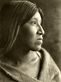
The Chemehuevi are an indigenous people of the Great Basin. They are the southernmost branch of Southern Paiute. Today, Chemehuevi people are enrolled in the following federally recognized tribes:

San Bernardino County, officially the County of San Bernardino, is a county located in the southern portion of the U.S. state of California, and is located within the Inland Empire area. As of the 2020 U.S. Census, the population was 2,181,654, making it the fifth-most populous county in California and the 14th-most populous in the United States. The county seat is San Bernardino.

Twentynine Palms is a city in San Bernardino County, California. Twentynine Palms serves as one of the entry points to Joshua Tree National Park.

The Sonoran Desert is a North American desert and ecoregion that covers part of the southwestern United States, as well as the northwestern Mexican states of Sonora, Baja California, and Baja California Sur. It is the hottest desert in both Mexico and the United States. It has an area of 260,000 square kilometers (100,000 sq mi).

The Antelope Valley is located in northern Los Angeles County, California, and the southeast portion of Kern County, California, and constitutes the western tip of the Mojave Desert. It is situated between the Tehachapi, Sierra Pelona, and the San Gabriel Mountains. The valley was named for the pronghorns that roamed there until they were all but eliminated in the 1880s, mostly by hunting, or resettled in other areas. The principal cities in the Antelope Valley are Palmdale and Lancaster.

The Low Desert is a common name for any desert in California that is under 2,000 feet in altitude. These areas include, but are not exclusive to, the Colorado Desert and Yuha Desert, in the Southern California portion of the Sonoran Desert. These areas are distinguished in biogeography from the adjacent northern High Desert or Mojave Desert by latitude, elevation, animal life, climate, and native plant communities.

The Coachella Valley is an arid rift valley in the Colorado Desert of Southern California's Riverside County. The valley may also be referred to as Greater Palm Springs due to the prominence of the city of Palm Springs. The valley extends approximately 45 mi (72 km) southeast from the San Gorgonio Pass to the northern shore of the Salton Sea and the neighboring Imperial Valley, and is approximately 15 mi (24 km) wide along most of its length. It is bounded on the northeast by the San Bernardino and Little San Bernardino Mountains, and on the southwest by the San Jacinto and Santa Rosa Mountains.

The Little San Bernardino Mountains are a short mountain range of the Transverse Ranges, located in southern California in the United States. They extend for approximately 40 mi (64 km) southeast from the San Bernardino Mountains through San Bernardino and Riverside Counties to near the northeast edge of the Salton Sink and Salton Sea.
The Cahuilla, also known as ʔívil̃uqaletem or Ivilyuqaletem, are a Native American people of the various tribes of the Cahuilla Nation, living in the inland areas of southern California. Their original territory included an area of about 2,400 square miles (6,200 km2). The traditional Cahuilla territory was near the geographic center of Southern California. It was bounded to the north by the San Bernardino Mountains, to the south by Borrego Springs and the Chocolate Mountains, to the east by the Colorado Desert, and to the west by the San Jacinto Plain and the eastern slopes of the Palomar Mountains.
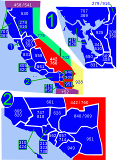
Area code 760 is a California telephone area code that was split from area code 619 on March 22, 1997. Area code 442 is an overlay of 760 that became effective on November 21, 2009. It encompasses much of the southeastern and southernmost portions of California. The area includes Imperial, Inyo, and Mono counties, as well as portions of San Diego, Riverside, San Bernardino, Los Angeles and Kern counties.
The Agua Caliente Band of Cahuilla Indians of the Agua Caliente Indian Reservation is a federally recognized tribe of the Cahuilla, located in Riverside County, California. They inhabited the Coachella Valley desert and surrounding mountains between 5000 BCE and 500 CE. With the establishment of the reservations, the Cahuilla were officially divided into 10 sovereign nations, including the Agua Caliente Band.

The Morongo Basin is an endorheic basin and valley region located in eastern San Bernardino County, in Southern California.

The Big Morongo Canyon Preserve is a 31,000-acres (130 km2) native plants habitat and wildlife preserve located in the Little San Bernardino Mountains of the Transverse Ranges, in the transition zone between the higher Mojave Desert and lower elevation Colorado Desert section of the Sonoran Desert. Due to its location within this transition zone, the area is especially high in natural diversity. The natural spring fed desert oasis found here is one of the 10 largest Cottonwood and Willow riparian habitats in California. It is also identified by the Audubon Society as one of the most important avian habitat areas in California.
Furnace Creek 508 was an ultramarathon bicycle race that took place annually each October between 1989 and 2013 in Southern California. Its route started in Santa Clarita, went northeast to Towne Pass and dropped into Death Valley, traversed Death Valley in the southern direction, crossed Mojave Desert and ended at Twentynine Palms. The race was named after the total length of its course and the location of its midpoint.

High Desert is a vernacular region with non-discrete boundaries applying to areas of the western Mojave Desert in southern California. The "High Desert" region is an area that generally is situated between 2,000 feet (610 m) and 4,000 feet (1,200 m) in elevation, and located just north of the San Gabriel, San Bernardino, and Little San Bernardino Mountains.

Los Angeles Air Route Traffic Control Center is an air traffic control center located in Palmdale, California, United States. It is located at the northeast corner of 25th Street East and Avenue P adjacent to USAF Plant 42 and the LA/Palmdale Regional Airport.

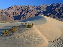
The Deserts of California have unique ecosystems and habitats, a sociocultural and historical "Old West" collection of legends, districts, and communities, and they also form a popular tourism region of dramatic natural features and recreational development. All of the deserts are located in eastern Southern California, in the Western United States.

The Morongo Band of Mission Indians is a federally recognized tribe in California, United States. The main tribal groups are Cahuilla and Serrano. Tribal members also include Cupeño, Luiseño, and Chemehuevi Indians. Although many tribes in California are known as Mission Indians, some, such as those at Morongo, were never a part of the Spanish Missions in California.

Sand to Snow National Monument is a U.S. National Monument located in San Bernardino County and northern Riverside County, Southern California.

Wonder Valley is a sparsely populated unincorporated community in the Morongo Basin of Southern California's High Desert region, straddling Amboy Road and State Route 62 in San Bernardino County, California, United States, approximately 10 miles (16 km) east of the city of Twentynine Palms.