Related Research Articles

Santa Cruz is the largest city and the county seat of Santa Cruz County, in Northern California. As of the 2020 census, the city population was 62,956. Situated on the northern edge of Monterey Bay, Santa Cruz is a popular tourist destination, owing to its beaches, surf culture, and historic landmarks.

Santa Cruz County, officially the County of Santa Cruz, is a county on the Pacific coast of the U.S. state of California. As of the 2020 census, the population was 270,861. The county seat is Santa Cruz. Santa Cruz County comprises the Santa Cruz–Watsonville, CA Metropolitan Statistical Area, which is also included in the San Jose–San Francisco–Oakland, CA Combined Statistical Area. The county is on the California Central Coast, south of the San Francisco Bay Area region. The county forms the northern coast of the Monterey Bay, with Monterey County forming the southern coast.

Watsonville is a city in Santa Cruz County, California, in the Monterey Bay Area of the Central Coast of California. The population was 52,590 at the 2020 census. Predominantly Latino and Democratic, Watsonville is a self-designated sanctuary city.

Northern California is a geographic and cultural region that comprises the northern portion of the U.S. state of California, spanning the northernmost 48 of the state's 58 counties. Northern California in its largest definition is determined by dividing the state into two regions, the other being Southern California. The main northern population centers include the San Francisco Bay Area, the Greater Sacramento area, the Redding, California, area south of the Cascade Range, and the Metropolitan Fresno area. Northern California also contains redwood forests, along with most of the Sierra Nevada, including Yosemite Valley and part of Lake Tahoe, Mount Shasta, and most of the Central Valley, one of the world's most productive agricultural regions. Northern California is also home to Silicon Valley, the global headquarters for some of the most powerful tech and Internet-related companies in the world, including Meta, Apple, Google, and Nvidia.

The Santa Cruz Mountains are a mountain range in central and Northern California, United States, constituting a part of the Pacific Coast Ranges. They form a ridge down the San Francisco Peninsula, south of San Francisco. They separate the Pacific Ocean from the San Francisco Bay and the Santa Clara Valley, and continue south to the Central Coast, bordering Monterey Bay and ending at the Salinas Valley. The range passes through the counties of San Mateo, Santa Clara, and Santa Cruz, with the Pajaro River forming the southern boundary.

The Central Coast is an area of California, roughly spanning the coastal region between Point Mugu and Monterey Bay. It lies northwest of Los Angeles and south of the San Francisco Bay Area, and includes the rugged, rural, and sparsely populated stretch of coastline known as Big Sur.

Año Nuevo State Park is a state park of California, United States, encompassing Año Nuevo Island and Año Nuevo Point, which are known for their pinniped rookeries. Located in San Mateo County, the low, rocky, windswept point juts out into the Pacific Ocean about 55 miles (89 km) south of San Francisco and the Golden Gate. Año Nuevo State Natural Reserve, formerly a separate unit of the California state park system, was merged into Año Nuevo State Park in October 2008. The coastal geographic center, or coastal-midpoint of California is located at the northern end of this park at 37°09′58″N122°21′40″W, as the absolute geographic center of California falls at 37°09′58″N119°26′58″W.
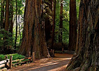
Big Basin Redwoods State Park is a state park in the U.S. state of California, located in Santa Cruz County, about 36 km (22 mi) northwest of Santa Cruz. The park contains almost all of the Waddell Creek watershed, which was formed by the seismic uplift of its rim, and the erosion of its center by the many streams in its bowl-shaped depression.
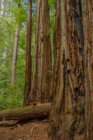
Henry Cowell Redwoods State Park is a state park of California, United States, preserving mainly forest and riparian areas in the watershed of the San Lorenzo River, including a grove of old-growth coast redwood. It is located in Santa Cruz County, primarily in the area between the cities of Santa Cruz and Scotts Valley, near the community of Felton and the University of California at Santa Cruz. The park includes a non-contiguous extension in the Fall Creek area north of Felton. The 4,623-acre (1,871 ha) park was established in 1953.

The Southern California Bight is a 692-kilometer-long stretch of curved coastline that runs along the west coast of the United States and Mexico, from Point Conception in California to Punta Colonet in Baja California, plus the area of the Pacific Ocean defined by that curve. This includes the Channel Islands of California and the Coronado Islands and Islas de Todo Santos of Baja California.

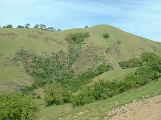
The Diablo Range is a mountain range in the California Coast Ranges subdivision of the Pacific Coast Ranges in northern California, United States. It stretches from the eastern San Francisco Bay Area at its northern end to the Salinas Valley area at its southern end.

The Coast Ranges of California span 400 miles (644 km) from Del Norte or Humboldt County, California, south to Santa Barbara County. The other three coastal California mountain ranges are the Transverse Ranges, Peninsular Ranges and the Klamath Mountains.

The California Coastal National Monument is located along the entire coastline of the U.S. state of California. This monument ensures the protection of all islets, reefs and rock outcroppings along the coast of California within 12 nautical miles (22 km) of shore along the entire 840-mile (1,350 km) long coastline. Conservative estimates are for at least 20,000 such outcroppings. The monument was created by Bill Clinton via Presidential proclamation on January 11, 2000, with the authority in section two of the Antiquities Act of 1906. As of 2014, the monument has expanded to 2,272 acres (919 ha). The U.S. Bureau of Land Management, an agency of the U.S. Department of the Interior that manages the monument, has developed gateways in cooperation with other agencies along the California coast to introduce the monument to the public. These include the Trinidad, Point Arena, Fort Bragg-Mendocino, Pigeon Point Lighthouse, Piedras Blancas State Marine Reserve and Marine Conservation Area, and the Palos Verdes Peninsula. Although being the most-viewed national monument in California, people are usually unaware that the entire coastline is a national monument.

The Pajaro River is a U.S. river in the Central Coast region of California, forming part of the border between San Benito and Santa Clara Counties, the entire border between San Benito and Santa Cruz County, and the entire border between Santa Cruz and Monterey County. Flowing roughly east to west, the river empties into Monterey Bay, west of Watsonville, California.

Carbonera Creek is a 10.2-mile-long (16.4 km) watercourse in Santa Cruz County, California, that eventually flows to the San Lorenzo River.

The California giant salamander is a species of salamander in the family Ambystomatidae. Dicamptodon ensatus is endemic to California, in the western United States. The species once additionally included individuals now belonging to the species D. aterrimus and D. tenebrosus, under the common name Pacific giant salamander, which now refers to the genus and family.

Lovers Point State Marine Reserve (SMR) is one of four small marine protected areas located near the cities of Monterey and Pacific Grove, at the southern end of Monterey Bay on California’s central coast. The four MPAs together encompass 2.96 square miles (7.7 km2). The SMR protects all marine life within its boundaries. Fishing and take of all living marine resources is prohibited.

The California coastal sage and chaparral is a Mediterranean forests, woodlands, and scrub ecoregion, defined by the World Wildlife Fund, located in southwestern California and northwestern Baja California (Mexico). It is part of the larger California chaparral and woodlands ecoregion. The ecoregion corresponds to the USDA Southern California ecoregion section 261B, and to the EPA Southern California/Northern Baja Coast ecoregion 8.
The California interior chaparral and woodlands ecoregion covers 24,900 square miles (64,000 km2) in an elliptical ring around the California Central Valley. It occurs on hills and mountains ranging from 300 feet (91 m) to 3,000 feet (910 m). It is part of the Mediterranean forests, woodlands, and scrub biome, with cool, wet winters and hot, dry summers. Temperatures within the coast can range from 53° to 65 °F and 32° to 60 °F within the mountains. Many plant and animal species in this ecoregion are adapted to periodic fire.
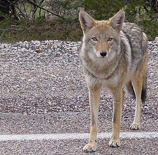
The fauna of the U.S. state of California may be the most diverse in the United States. Of the lower 48 contiguous states, California has the greatest diversity in climate, terrain, and geology. The state's six life zones are the lower Sonoran (desert); upper Sonoran ; transition ; and the Canadian, Hudsonian, and Arctic zones, comprising California's highest elevations. California's diverse geography gives rise to dozens of ecosystems, each of which has its own native plants and animals. California is a huge state, the third largest in the U.S., and ranges broadly in habitats.
References
- ↑ David L. Suddjian (2006). "Checklist of the Birds of Santa Cruz County, California" (PDF). Santa Cruz Bird Club. Archived from the original (PDF) on 2011-08-13. Retrieved 2011-12-19.
- ↑ Richard C. McGregor (May 15, 1901). Pacific Coast Avifauna No. 2--A List of Land Birds of Santa Cruz County, California (PDF) (Report). Santa Clara, CA: Cooper Ornithological Club of California. Retrieved 2011-12-19.
- ↑ This seasonal checklist was developed from records compiled by the Santa Cruz Bird Club. Updated most recently September 30, 2002.
Municipalities and communities of Santa Cruz County, California, United States | ||
|---|---|---|
| Cities |  | |
| CDPs | ||
| Unincorporated communities | ||
| Ghost town | ||