List of circles of latitude

Last updated

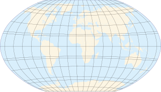
This article contains a list of notable circles of latitude on Earth.

Contents

Day length for any latitude, and sunrise and sunset times on any longitude, can be calculated for any date using, for example, the sunrise equation. Online calculators are also available, such as from NOAA. [1]

Northern Hemisphere
LatitudeGeographic crossingsSettlement crossingsPolitical boundariesOther
90°N North Pole
89°NLies entirely in the Arctic Ocean
88°NLies entirely in the Arctic Ocean
87°NLies entirely in the Arctic Ocean
86°NLies entirely in the Arctic Ocean
85°NLies entirely in the Arctic Ocean
84°NLies entirely in the Arctic Ocean
83°NFlag of Greenland.svg  Greenland: 83°0′N46°39′W / 83.000°N 46.650°W / 83.000; -46.650 (Greenland) Sverdrup Island; 83°0′N46°13′W / 83.000°N 46.217°W / 83.000; -46.217 (Lincoln Sea) Mascart Sound; 83°0′N43°45′W / 83.000°N 43.750°W / 83.000; -43.750 (Greenland) Nansen Land; 83°0′N41°33′W / 83.000°N 41.550°W / 83.000; -41.550 (Lincoln Sea) Thomas Thomsen Fjord; 83°0′N41°19′W / 83.000°N 41.317°W / 83.000; -41.317 (Greenland) Borup Island; 83°0′N40°38′W / 83.000°N 40.633°W / 83.000; -40.633 (Lincoln Sea) Adolf Jensen Fjord; 83°0′N39°45′W / 83.000°N 39.750°W / 83.000; -39.750 (Greenland) MacMillan Island; 83°0′N39°43′W / 83.000°N 39.717°W / 83.000; -39.717 (Lincoln Sea) De Long Fjord; 83°0′N36°47′W / 83.000°N 36.783°W / 83.000; -36.783 (Greenland) Amundsen Land; 83°0′N33°20′W / 83.000°N 33.333°W / 83.000; -33.333 (Lincoln Sea) Frederick E. Hyde Fjord / Citronen Fjord; 83°0′N28°40′W / 83.000°N 28.667°W / 83.000; -28.667 (Greenland) Hans Egede Land
82°NFlag of Greenland.svg  Greenland: 82°0′N59°59′W / 82.000°N 59.983°W / 82.000; -59.983 (Greenland) Nyeboe Land; 82°0′N54°13′W / 82.000°N 54.217°W / 82.000; -54.217 (Sherard Osborn Fjord) St George Fjord; 82°0′N52°43′W / 82.000°N 52.717°W / 82.000; -52.717 (Greenland) Hendrik Island; 82°0′N51°34′W / 82.000°N 51.567°W / 82.000; -51.567 (Sherard Osborn Fjord) Sherard Osborn Fjord; 82°0′N49°0′W / 82.000°N 49.000°W / 82.000; -49.000 (Greenland) Wulff Land; 82°0′N46°31′W / 82.000°N 46.517°W / 82.000; -46.517 (Victoria Fjord) Victoria Fjord; 82°0′N32°26′W / 82.000°N 32.433°W / 82.000; -32.433 (Greenland) Christian Erichsen Ice Cap; 82°0′N29°57′W / 82.000°N 29.950°W / 82.000; -29.950 (Independence Fjord) Independence Fjord; 82°0′N24°48′W / 82.000°N 24.800°W / 82.000; -24.800 (Greenland) Cape Peter Henrik; 82°0′N23°55′W / 82.000°N 23.917°W / 82.000; -23.917 (Independence Fjord) Hagen Fjord; 82°0′N23°10′W / 82.000°N 23.167°W / 82.000; -23.167 (Greenland) Cape Rigsdagen; 82°0′N21°18′W / 82.000°N 21.300°W / 82.000; -21.300 (Greenland) Princess Thyra Island; 82°0′N20°17′W / 82.000°N 20.283°W / 82.000; -20.283 (Greenland) Princess Margaret Island
81°N 81°0′N38°0′E / 81.000°N 38.000°E / 81.000; 38.000 (Arctic Ocean) Queen Victoria Sea, Arctic Ocean
81°0′N54°27′E / 81.000°N 54.450°E / 81.000; 54.450 (Russia) Franz Josef Land - Zichy Land, Flag of Russia.svg  Russia
81°0′N60°13′E / 81.000°N 60.217°E / 81.000; 60.217 (Russia) Franz Josef Land - La Ronciere Island, Flag of Russia.svg  Russia
81°0′N64°10′E / 81.000°N 64.167°E / 81.000; 64.167 (Russia) Franz Josef Land - Graham Bell Island, Flag of Russia.svg  Russia
81°0′N93°45′E / 81.000°N 93.750°E / 81.000; 93.750 (Russia) Severnaya Zemlya - Komsomolets Island, Flag of Russia.svg  Russia
81°0′N95°16′W / 81.000°N 95.267°W / 81.000; -95.267 (Canada) Nunavut - Axel Heiberg Island, Flag of Canada (Pantone).svg  Canada
81°0′N91°38′W / 81.000°N 91.633°W / 81.000; -91.633 (Nansen Sound) , Nansen Sound
81°0′N66°52′W / 81.000°N 66.867°W / 81.000; -66.867 (Nares Strait) , Nares Strait
81°0′N61°25′W / 81.000°N 61.417°W / 81.000; -61.417 (Greenland) Petermann Glacier, Flag of Greenland.svg  Greenland
81°0′N19°5′W / 81.000°N 19.083°W / 81.000; -19.083 (Greenland) Romer Lake, Flag of Greenland.svg  Greenland
1°N 1°0′N9°31′E / 1.000°N 9.517°E / 1.000; 9.517 (Equatorial Guinea) Island of Elobey Chico, Flag of Equatorial Guinea.svg  Equatorial Guinea
1°0′N97°23′E / 1.000°N 97.383°E / 1.000; 97.383 (Indonesia) Island of Nias, Flag of Indonesia.svg  Indonesia
1°0′N98°56′E / 1.000°N 98.933°E / 1.000; 98.933 (Indonesia) Meranti Islands, Flag of Indonesia.svg
1°0′N103°47′E / 1.000°N 103.783°E / 1.000; 103.783 (Indonesia) Riau Islands, Flag of Indonesia.svg
1°0′N107°23′E / 1.000°N 107.383°E / 1.000; 107.383 (Indonesia) Tambelan archipelago, Flag of Indonesia.svg
1°0′N173°0′E / 1.000°N 173.000°E / 1.000; 173.000 (Kiribati) Maiana atoll, Flag of Kiribati.svg  Kiribati
Equatorial Guinea and Gabon [2]


Northern Hemisphere

Equator

The equator, a circle of latitude that divides a spheroid, such as Earth, into the northern and southern hemispheres. On Earth, it is an imaginary line located at 0 degrees latitude.

Southern Hemisphere

  1. NOAA. "NOAA Solar Calculator". ESRL Global Monitoring Laboratory - Global Radiation and Aerosols. Retrieved 28 January 2024.
  2. "Equatorial Guinea–Gabon". Sovereign Limits. Retrieved 7 October 2022.

Related Research Articles

<span class="mw-page-title-main">Latitude</span> Geographic coordinate specifying north–south position

In geography, latitude is a coordinate that specifies the north–south position of a point on the surface of the Earth or another celestial body. Latitude is given as an angle that ranges from –90° at the south pole to 90° at the north pole, with 0° at the Equator. Lines of constant latitude, or parallels, run east–west as circles parallel to the equator. Latitude and longitude are used together as a coordinate pair to specify a location on the surface of the Earth.

<span class="mw-page-title-main">North Pole</span> Northern point where the Earths axis of rotation intersects its surface

The North Pole, also known as the Geographic North Pole, Terrestrial North Pole or 90th Parallel North, is the point in the Northern Hemisphere where the Earth's axis of rotation meets its surface. It is called the True North Pole to distinguish from the Magnetic North Pole.

<span class="mw-page-title-main">Northern Hemisphere</span> Half of Earth that is north of the Equator

The Northern Hemisphere is the half of Earth that is north of the Equator. For other planets in the Solar System, north is defined as being in the same celestial hemisphere relative to the invariable plane of the Solar System as Earth's North Pole.

A solstice is an event that occurs when the Sun reaches its most northerly or southerly excursion relative to the celestial equator on the celestial sphere. Two solstices occur annually, around June 21 and December 21. In many countries, the seasons of the year are determined by the solstices and the equinoxes.

<span class="mw-page-title-main">Tropics</span> Region of Earth surrounding the Equator

The tropics are the regions of Earth surrounding the Equator. They are defined in latitude by the Tropic of Cancer in the Northern Hemisphere at 23°26′10.2″ (or 23.43616°) N and the Tropic of Capricorn in the Southern Hemisphere at 23°26′10.2″ (or 23.43616°) S. The tropics are also referred to as the tropical zone and the torrid zone.

<span class="mw-page-title-main">Tropic of Cancer</span> Line of northernmost latitude at which the Sun can be directly overhead

The Tropic of Cancer, which is also referred to as the Northern Tropic, is the most northerly circle of latitude on Earth at which the Sun can be directly overhead. This occurs on the June solstice, when the Northern Hemisphere is tilted toward the Sun to its maximum extent. It also reaches 90 degrees below the horizon at solar midnight on the December Solstice. Using a continuously updated formula, the circle is currently 23°26′10.2″ (or 23.43616°) north of the Equator.

<span class="mw-page-title-main">Tropic of Capricorn</span> Line of southernmost latitude at which the sun can be directly overhead

The Tropic of Capricorn is the circle of latitude that contains the subsolar point at the December solstice. It is thus the southernmost latitude where the Sun can be seen directly overhead. It also reaches 90 degrees below the horizon at solar midnight on the June Solstice. Its northern equivalent is the Tropic of Cancer.

<span class="mw-page-title-main">Circumpolar star</span> Star that never sets due to its apparent proximity to a celestial pole

A circumpolar star is a star that, as viewed from a given latitude on Earth, never sets below the horizon due to its apparent proximity to one of the celestial poles. Circumpolar stars are therefore visible from said location toward the nearest pole for the entire night on every night of the year. Others are called seasonal stars.

<span class="mw-page-title-main">Circle of latitude</span> Geographic notion

A circle of latitude or line of latitude on Earth is an abstract east–west small circle connecting all locations around Earth at a given latitude coordinate line.

<span class="mw-page-title-main">Polar circle</span> Circle of latitude

A polar circle is a geographic term for a conditional circular line (arc) referring either to the Arctic Circle or the Antarctic Circle. These are two of the keynote circles of latitude (parallels). On Earth, the Arctic Circle is currently drifting northwards at a speed of about 14.5 m per year and is now at a mean latitude of 66°33′49.8″ N; the Antarctic Circle is currently drifting southwards at a speed of about 14.5 m per year and is now at a mean latitude of 66°33′49.8″ S. Polar circles are often equated with polar regions of Earth. Due to their inherent climate environment, the bulk of the Arctic Circle, much of which is sea, is sparsely settled whereas this applies to all of Antarctica which is mainly land and sheltered ice shelves.

<span class="mw-page-title-main">Twilight</span> Atmospheric illumination by the Sun below the horizon

Twilight is light produced by sunlight scattering in the upper atmosphere, when the Sun is below the horizon, which illuminates the lower atmosphere and the Earth's surface. The word twilight can also refer to the periods of time when this illumination occurs.

<span class="mw-page-title-main">Middle latitudes</span> Spatial region on Earth

The middle latitudes are a spatial region on Earth located between the Tropic of Cancer to the Arctic Circle (66°33'39"), and Tropic of Capricorn (-23°26'22") to the Antarctic Circle (-66°33'39"). They include Earth's subtropical and temperate zones, which lie between the two tropics and the polar circles. Weather fronts and extratropical cyclones are usually found in this area, as well as occasional tropical cyclones or subtropical cyclones, which have traveled from their areas of formation closer to the Equator.

<span class="mw-page-title-main">Polar night</span> Night lasting for more than 24 hours

Polar night is a phenomenon in the northernmost and southernmost regions of Earth where night lasts for more than 24 hours. This occurs only inside the polar circles. The opposite phenomenon, polar day, or midnight sun, occurs when the Sun remains above the horizon for more than 24 hours.

<span class="mw-page-title-main">Geographical zone</span> Major regions of Earths surface demarcated by latitude

The five main latitude regions of Earth's surface comprise geographical zones, divided by the major circles of latitude. The differences between them relate to climate. They are as follows:

  1. The North Frigid Zone, between the North Pole at 90° N and the Arctic Circle at 66°33′48.7" N, covers 4.12% of Earth's surface.
  2. The North Temperate Zone, between the Arctic Circle at 66°33′48.7" N and the Tropic of Cancer at 23°26'11.3" N, covers 25.99% of Earth's surface.
  3. The Torrid Zone, between the Tropic of Cancer at 23°26'11.3" N and the Tropic of Capricorn at 23°26'11.3" S, covers 39.78% of Earth's surface.
  4. The South Temperate Zone, between the Tropic of Capricorn at 23°26'11.3" S and the Antarctic Circle at 66°33'48.7" S, covers 25.99% of Earth's surface.
  5. The South Frigid Zone, from the Antarctic Circle at 66°33'48.7" S and the South Pole at 90° S, covers 4.12% of Earth's surface.
<span class="mw-page-title-main">Daytime</span> Period of a day in which a location experiences natural illumination

Daytime as observed on Earth is the period of the day during which a given location experiences natural illumination from direct sunlight. Daytime occurs when the Sun appears above the local horizon, that is, anywhere on the globe's hemisphere facing the Sun. In direct sunlight the movement of the sun can be recorded and observed using a sundial that casts a shadow that slowly moves during the day. Other planets and natural satellites that rotate relative to a luminous primary body, such as a local star, also experience daytime, but this article primarily discusses daytime on Earth.

<span class="mw-page-title-main">Sun path</span> Arc-like path that the Sun appears to follow across the sky

Sun path, sometimes also called day arc, refers to the daily and seasonal arc-like path that the Sun appears to follow across the sky as the Earth rotates and orbits the Sun. The Sun's path affects the length of daytime experienced and amount of daylight received along a certain latitude during a given season.

The 40th parallel south is a circle of latitude that is 40 degrees south of the Earth's equatorial plane. It crosses the Atlantic Ocean, the Indian Ocean, Australasia, the Pacific Ocean and South America. Its long oceanic stretches are the northern domain of the Roaring Forties.

<span class="mw-page-title-main">Equator</span> Imaginary line halfway between Earths North and South poles

The equator is a circle of latitude that divides a spheroid, such as Earth, into the Northern and Southern hemispheres. On Earth, the Equator is an imaginary line located at 0 degrees latitude, about 40,075 km (24,901 mi) in circumference, halfway between the North and South poles. The term can also be used for any other celestial body that is roughly spherical.

<span class="mw-page-title-main">Antarctic Circle</span> Boundary of the Antarctic

The Antarctic Circle is the most southerly of the five major circles of latitude that mark maps of Earth. The region south of this circle is known as the Antarctic, and the zone immediately to the north is called the Southern Temperate Zone. South of the Antarctic Circle, the Sun is above the horizon for 24 continuous hours at least once per year and the centre of the Sun is below the horizon for 24 continuous hours at least once per year ; this is also true within the equivalent polar circle in the Northern Hemisphere, the Arctic Circle.

<span class="mw-page-title-main">Arctic Circle</span> Boundary of the Arctic

The Arctic Circle is one of the two polar circles, and the most northerly of the five major circles of latitude as shown on maps of Earth at about 66° 34' N. Its southern equivalent is the Antarctic Circle.