Lighthouses
| Name | Image | Year built | Location & coordinates | Class of Light [2] | Focal height [2] | NGA number [2] | Admiralty number [2] | Range nml [2] |
|---|---|---|---|---|---|---|---|---|
| Abu Ali Lighthouse |  | 1903 | Abu Ali Island 14°04′41.9″N42°48′53.9″E / 14.078306°N 42.814972°E | Fl (2) W 10s. | 104 metres (341 ft) | 30892 | D7300.8 | 13 |
| Aden Entrance Range Rear Lighthouse | n/a | Aden 12°47′20.1″N44°53′06.2″E / 12.788917°N 44.885056°E | Iso G 2s. | 26 metres (85 ft) | 30951 | D7302.1 | 10 | |
| Al Khawtamah Lighthouse | 2006 | Al Khawtamah Island 15°41′14.8″N42°17′08.3″E / 15.687444°N 42.285639°E | inactive | 12 metres (39 ft) tower | n/a | ex-E6144.5 | n/a | |
| Mukalla South Breakwater Lighthouse | ~2009 | Mukalla 14°31′16.9″N49°08′50.2″E / 14.521361°N 49.147278°E | Fl W 5s. | 17 metres (56 ft) | 30920 | D7312 | 15 | |
| Balfe Point Lighthouse | Image | n/a | Perim 12°39′38.3″N43°23′19.9″E / 12.660639°N 43.388861°E | Fl W 4s. | 13 metres (43 ft) | 30896 | D7300.9 | 11 |
| Balhaf Lighthouse | n/a | Balhaf 13°58′54.0″N48°11′14.0″E / 13.981667°N 48.187222°E | Fl W 5s. | 90 metres (300 ft) | 30923 | D7311.23 | 20 | |
| Dawharab Lighthouse | n/a | Dawharab 16°19′23.8″N41°58′04.1″E / 16.323278°N 41.967806°E | Fl W 4s. | 15 metres (49 ft) | 30784 | D7300 | 10 | |
| Elephant's Back Lighthouse | 1909 | Aden 12°45′52.4″N44°59′09.6″E / 12.764556°N 44.986000°E | Fl WR 2.5s. | 57 metres (187 ft) | 30940 | D7308 | 24 | |
| Jabal al-Tair Lighthouse | Image | 1989 | Jabal al-Tair Island 15°32′18.7″N41°49′30.1″E / 15.538528°N 41.825028°E | inactive | n/a | ex-30792 | ex-E6140 | n/a |
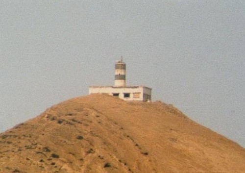
| Jaza'ir az Zubayr Lighthouse | Image | 1987 | Zubair Islands 15°00′54.3″N42°09′51.2″E / 15.015083°N 42.164222°E | Fl W 10s. | 154 metres (505 ft) | 30829 | D7300.61 | 12 |
| Jazirat al Hanish Lighthouse | Image | 2005 | Hanish Islands ~ 13°39′36.6″N42°40′45.1″E / 13.660167°N 42.679194°E | Fl W 5s. | 200 metres (660 ft) | n/a | D7300.84 | n/a |
| Jazirat Salil Lighthouse | Image | n/a | Aden 12°44′19.5″N44°55′01.6″E / 12.738750°N 44.917111°E | Fl (2) R 15s. | 20 metres (66 ft) | 30948 | D7301 | 3 |
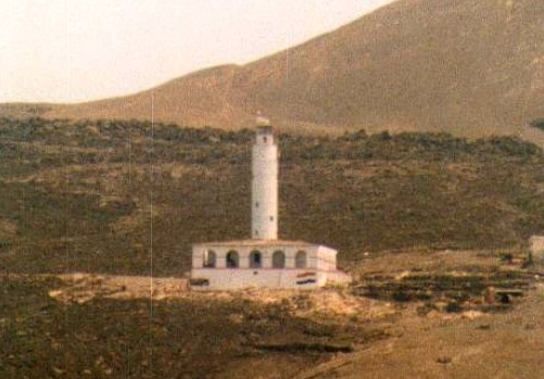
| Jebel Yemen Lighthouse | Image | ~1970 | Kamaran 15°17′19.6″N42°34′56.0″E / 15.288778°N 42.582222°E | Fl (3) W 15s. | 40 metres (130 ft) | 30800 | D7300.58 | 10 |
| Mayyun High Lighthouse |  | n/a | Perim 12°39′17.6″N43°25′52.8″E / 12.654889°N 43.431333°E | Fl (4) W 15s. | 85 metres (279 ft) | 30900 | D7300.95 | 24 |
| Mocha Range Rear Lighthouse | Image | n/a | Mocha 13°18′32.0″N43°14′12.2″E / 13.308889°N 43.236722°E | Iso W 2s. | n/a | 30848 | D7300.861 | 9 |
| Nishtun Lighthouse | n/a | Nishtun 15°49′14.1″N52°11′57.9″E / 15.820583°N 52.199417°E | Fl W 9s. | 42 metres (138 ft) | 30904 | D7313 | 18 | |
| Ra's Marbut | Image | n/a | Aden 12°47′25.1″N44°58′12.8″E / 12.790306°N 44.970222°E | L Fl G 5s. | 20 metres (66 ft) | 30944 | D7309 | 10 |
| Ra's Marshaq Lighhtouse | Image | 1867 | Aden 12°45′48.0″N45°03′14.4″E / 12.763333°N 45.054000°E | Oc W 5s. | 74 metres (243 ft) | 30936 | D7304 | 24 |
