External links
- Rowlett, Russ. "The Lighthouse Directory". University of North Carolina at Chapel Hill.
| Types |
|  | ||||
|---|---|---|---|---|---|---|
| Fixtures | ||||||
| Maintenance | ||||||
| Locations | ||||||
| Categories | ||||||
| Global organizations | ||||||
This is a list of lighthouses in British Indian Ocean Territory . [1] [2]
| Name | Image | Year built | Location & coordinates | Class of Light [2] | Focal height [2] | NGA number [2] | Admiralty number [2] | Range nml [2] |
|---|---|---|---|---|---|---|---|---|
| Control Tower Light | n/a | Diego Garcia 7°18′29.8″S72°24′42.2″E / 7.308278°S 72.411722°E | Al Fl WG 10s. | 40 metres (130 ft) | 33036 | k0800 | 12 | |
| Diego Garcia Harbour Control Tower Lighthouse | ~1980s | Diego Garcia 7°17′27.8″S72°23′39.4″E / 7.291056°S 72.394278°E | F R | 13 metres (43 ft) | 33052 | K0806 | n/a | |
| Leconte Point Lighthouse | n/a | Diego Garcia 7°16′37.9″S72°28′08.8″E / 7.277194°S 72.469111°E | Fl R 2.5s. | 10 metres (33 ft) | 33060 | K0807 | 3 | |
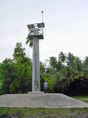
| Minni Minni Lighthouse | Image | 2002 | Diego Garcia 7°19′36.3″S72°28′28.4″E / 7.326750°S 72.474556°E | F WRG | 14 metres (46 ft) | 33064 | K0808.5 | white: 20 red: 16 green: 16 |
| Observation Point Lighthouse | n/a | Diego Garcia 7°14′19.9″S72°26′06.1″E / 7.238861°S 72.435028°E | Fl W 4s. | 10 metres (33 ft) | 33056 | K0802 | 5 | |
| West Island Lighthouse | n/a | Diego Garcia 7°14′51.2″S72°23′07.3″E / 7.247556°S 72.385361°E | Fl (2) W 5s. | 10 metres (33 ft) | 33040 | K0801 | 6 | |
| Types |
| | ||||
|---|---|---|---|---|---|---|
| Fixtures | ||||||
| Maintenance | ||||||
| Locations | ||||||
| Categories | ||||||
| Global organizations | ||||||