List of municipalities in Mato Grosso by HDI

Last updated

This is a list of municipalities in Mato Grosso ordered by Human Development Index (HDI) according to data released by the United Nations Development Program (UNDP) of the United Nations for 2010 (although old, they are the most current data available). [1] [2] The Human Development Index was developed in 1990 by the Pakistani economist Mahbub ul Haq and the Indian economist Amartya Sen. [3] [4]

Contents

According to the list. of the 141 municipalities in the state of Mato Grosso, none of them have very high HDI (equal to or greater than 0.800), 49 have high HDI (between 0.700 and 0.799), 89 have medium (between 0.600 and 0.699), 3 have low (between 0.500 and 0.599), and none of them have a very low (less than 0.500). The HDI of the state of Mato Grosso is 0.774 (considered high). [5]

Criteria

Map of HDI of the municipalities of Mato Grosso.
Legend:
.mw-parser-output .legend{page-break-inside:avoid;break-inside:avoid-column}.mw-parser-output .legend-color{display:inline-block;min-width:1.25em;height:1.25em;line-height:1.25;margin:1px 0;text-align:center;border:1px solid black;background-color:transparent;color:black}.mw-parser-output .legend-text{}
Very high (no municipalities)
High (49 municipalities)
Medium (89 municipalities)
Low (3 municipalities)
Very low (no municipalities) Mapa do IDH de Mato Grosso (2010).svg
Map of HDI of the municipalities of Mato Grosso.
Legend:
  Very high (no municipalities)
  High (49 municipalities)
  Medium (89 municipalities)
  Low (3 municipalities)
  Very low (no municipalities)

Categories

The index varies from 0 to 1, considering:

Components

The HDI of the municipalities is an average between the income index,life expectancy index and educational index.

List

RankMunicipalitiesDados de 2010
HDIIncome

Index

Life

Expectancy

Index

Educational

Index

Very high HDI
no municipalities
High HDI
1 Cuiabá (capital city)0.7850.8000.8340.726
2 Lucas do Rio Verde 0.7680.7660.8330.710
3 Nova Mutum 0.7580.7730.8370.673
4 Rondonópolis 0.7550.7490.8230.698
5 Sinop 0.7540.7550.8320.682
6 Primavera do Leste 0.7520.7740.8430.653
7 Campo Verde 0.7500.7550.8340.670
8 Barra do Garças 0.7480.7380.8170.693
9 Sorriso 0.7440.7740.8390.635
10 Campos de Júlio 0.7440.8000.8250.625
11 Jaciara 0.7350.7280.8330.655
12 Santa Rita do Trivelato 0.7350.7380.8520.632
13 Várzea Grande 0.7340.7110.8420.661
14 Campo Novo do Parecis 0.7340.7450.8190.649
15 Pontal do Araguaia 0.7340.6910.8160.702
16 Sapezal 0.7320.7580.8360.620
17 Água Boa 0.7290.7230.8290.646
18 Tangará da Serra 0.7290.7490.8250.626
19 Ipiranga do Norte 0.7270.7420.8070.642
20 Araputanga 0.7250.7040.8260.655
21 São José dos Quatro Marcos 0.7190.7070.8160.643
22 Diamantino 0.7180.7140.8310.625
23 Conquista d'Oeste 0.7180.7070.8070.650
24 Matupá 0.7160.7060.8240.631
25 Juína 0.7160.7330.8450.593
26 Torixoréu 0.7160.6840.8060.666
27 Santa Carmem 0.7150.7030.8270.628
28 Alta Floresta 0.7140.7090.8170.629
29 Juscimeira 0.7140.6780.8420.637
30 Tapurah 0.7140.7380.8310.594
31 Nova Santa Helena 0.7140.7450.8090.603
32 Colíder 0.7130.7320.8190.604
33 Itanhangá 0.7100.6990.8560.597
34 Glória d'Oeste 0.7100.6840.8230.636
35 Cáceres 0.7080.6910.8130.633
36 Rio Branco 0.7070.7010.8170.617
37 Guiratinga 0.7050.6770.8130.637
38 Alto Taquari 0.7050.7360.8330.571
39 Nova Xavantina 0.7040.7130.8000.613
40 Alto Araguaia 0.7040.7120.8020.612
41 Arenápolis 0.7040.6770.7930.649
42 Mirassol d'Oeste 0.7040.7230.8160.592
43 Nova Marilândia 0.7040.6800.8230.623
44 Pontes e Lacerda 0.7030.7110.8070.605
45 Guarantã do Norte 0.7030.6920.8260.609
46 Nortelândia 0.7020.6530.7930.668
47 Marcelândia 0.7010.7000.8130.604
48 Araguainha 0.7010.6500.8440.627
49 Alto Garças 0.7010.7070.8350.583
Medium HDI
50 Cláudia 0.6990.7190.8090.586
51 Nobres 0.6990.6750.8270.611
52 Terra Nova do Norte 0.6980.6920.8150.602
53 Brasnorte 0.6960.6950.8500.571
54 Tabaporã 0.6950.6790.8260.598
55 Itiquira 0.6930.6940.8120.591
56 Barra do Bugres 0.6930.6840.8180.595
57 Canarana 0.6930.7350.8250.549
58 Querência 0.6920.7010.8370.565
59 Feliz Natal 0.6920.7370.8190.548
60 Ribeirãozinho 0.6920.6940.8020.595
61 Nova Monte Verde 0.6910.6900.8230.582
62 Itaúba 0.6900.7140.8090.569
63 Dom Aquino 0.6900.6870.8060.593
64 Curvelândia 0.6900.6580.8110.615
65 Comodoro 0.6890.6870.8400.567
66 Santo Afonso 0.6890.6550.8340.599
67 Chapada dos Guimarães 0.6880.6770.8330.578
68 Vila Rica 0.6880.7090.8290.553
69 Nova Guarita 0.6880.6710.8120.597
70 Araguaiana 0.6870.6710.8170.591
71 Ponte Branca 0.6860.6840.8060.585
72 Nova Canaã do Norte 0.6860.6920.8150.572
73 Porto dos Gaúchos 0.6850.7030.8150.561
74 Santa Cruz do Xingu 0.6840.7040.8280.550
75 Denise 0.6830.6720.8020.590
76 Nova Olímpia 0.6820.7040.8040.561
77 Juara 0.6820.6990.8360.543
78 São José do Rio Claro 0.6820.6890.8410.548
79 Vera 0.6800.6630.8340.568
80 Pedra Preta 0.6790.6720.8120.573
81 Figueirópolis d'Oeste 0.6790.6650.7860.599
82 Poxoréo 0.6780.6530.8320.573
83 Luciara 0.6760.6170.7880.634
84 Reserva do Cabaçal 0.6760.6420.7990.603
85 Aripuanã 0.6750.6820.8160.553
86 Apiacás 0.6750.6660.8090.570
87 Novo Mundo 0.6740.6520.8150.577
88 Jauru 0.6730.6680.8120.563
89 Porto Alegre do Norte 0.6730.6470.8030.587
90 Paranaíta 0.6720.6770.8090.555
91 General Carneiro 0.6700.6450.8200.569
92 Ribeirão Cascalheira 0.6700.6680.8310.542
93 Nova Ubiratã 0.6690.6940.8160.529
94 São Félix do Araguaia 0.6680.6520.8480.538
95 Confresa 0.6680.6600.8120.556
96 Paranatinga 0.6670.6790.8200.532
97 Canabrava do Norte 0.6670.6160.8170.589
98 Salto do Céu 0.6660.6610.7970.560
99 Castanheira 0.6650.6710.8000.547
100 Carlinda 0.6650.6560.8090.553
101 União do Sul 0.6650.6650.7970.556
102 Novo Horizonte do Norte 0.6640.6520.8200.548
103 Serra Nova Dourada 0.6640.6380.8190.560
104 Nova Maringá 0.6630.7020.8150.509
105 Juruena 0.6620.6470.7970.563
106 Indiavaí 0.6610.6450.8410.533
107 São José do Povo 0.6610.6300.7930.577
108 Bom Jesus do Araguaia 0.6610.6650.7840.555
109 São Pedro da Cipa 0.6600.6540.7900.556
110 Cocalinho 0.6600.6740.8070.528
111 São José do Xingu 0.6570.7030.8280.487
112 Vale de São Domingos 0.6560.6580.7650.560
113 Planalto da Serra 0.6560.6150.8130.565
114 Santo Antônio de Leverger 0.6560.6510.8060.539
115 Santo Antônio do Leste 0.6550.6580.8530.501
116 Tesouro 0.6550.6350.7910.560
117 Novo Santo Antônio 0.6530.6400.8290.526
118 Poconé 0.6520.6430.8060.534
119 Porto Esperidião 0.6520.6660.7950.523
120 Nova Brasilândia 0.6510.6730.8450.485
121 Alto Boa Vista 0.6510.6130.8030.561
122 Rosário Oeste 0.6500.6530.8070.520
123 Nova Bandeirantes 0.6500.6960.8420.469
124 Novo São Joaquim 0.6490.6580.8190.507
125 Peixoto de Azevedo 0.6490.6910.7610.521
126 Vila Bela da Santíssima Trindade 0.6450.6440.8430.495
127 Rondolândia 0.6400.6190.8000.530
128 Alto Paraguai 0.6380.6120.7840.541
129 Nossa Senhora do Livramento 0.6380.6000.8200.529
130 Nova Lacerda 0.6360.6430.8250.485
131 Jangada 0.6300.5670.8050.549
132 Acorizal 0.6280.5940.8160.510
133 Lambari d'Oeste 0.6270.6700.7870.467
134 Gaúcha do Norte 0.6150.6580.8470.418
135 Colniza 0.6110.6330.8150.443
136 Santa Terezinha 0.6090.5960.7610.498
137 Cotriguaçu 0.6010.6230.8250.423
138 Barão de Melgaço 0.6000.5980.8200.440
Low HDI
139 Porto Estrela 0.5990.5710.8040.467
140 Nova Nazaré 0.5950.6210.7930.427
141 Campinápolis 0.5380.5970.8030.324
Very low HDI
no municipalities

Related Research Articles

<span class="mw-page-title-main">Santarém Novo</span> Municipality in Northern, Brazil

Santarém Novo is a municipality in the state of Pará in the Northern region of Brazil.

<span class="mw-page-title-main">Itaúna</span> Municipality in Southeast, Brazil

Itaúna is a municipality in the state of Minas Gerais in the Southeast region of Brazil.

<span class="mw-page-title-main">São João Evangelista</span> Municipality in Southeast, Brazil

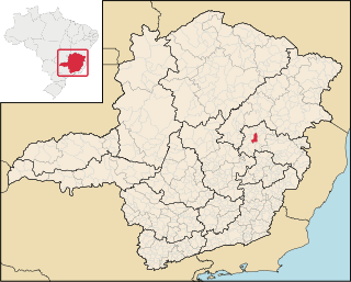
São João Evangelista is a municipality in the state of Minas Gerais in the Southeast region of Brazil.

<span class="mw-page-title-main">Peçanha</span> Municipality in Southeast, Brazil

Peçanha is a municipality in the state of Minas Gerais in the Southeast region of Brazil.

<span class="mw-page-title-main">Rio Preto, Minas Gerais</span> Place in Southeast, Brazil

Rio Preto is a municipality in the state of Minas Gerais in the Southeast region of Brazil.

<span class="mw-page-title-main">Alto Paraguai</span> Municipality in Center-West, Brazil

Alto Paraguai is a municipality in the state of Mato Grosso in the Mid-West of Brazil.

<span class="mw-page-title-main">Confresa</span> Municipality in Center-West, Brazil

Confresa is a municipality in the state of Mato Grosso in the Central-West Region of Brazil.

<span class="mw-page-title-main">Porto Alegre do Norte</span> Municipality in Center-West, Brazil

Porto Alegre do Norte is a municipality in the state of Mato Grosso in the Central-West Region of Brazil.

<span class="mw-page-title-main">Nova Mutum</span> Municipality in Center-West, Brazil

Nova Mutum is a municipality in the state of Mato Grosso in the Central-West Region of Brazil. It belongs to micro Alto Teles Pires and meso Norte Mato-Grossense, a distance of 242 kilometres (150 mi) north of Cuiabá, the state capital. Its population was estimated in 2020 by the Brazilian Institute of Geography and Statistics as 46,813 people.

<span class="mw-page-title-main">Juara</span> Municipality in Central-West, Brazil

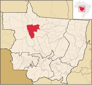
Juara is a municipality located in the state of Mato Grosso in the Central-West Region of Brazil. It is known as the Cattle Capital. Its area is 22,622.350 km2 (8,734.538 sq mi), and its population is 35,121 inhabitants. The town's economy is based in three field: Wood extraction, cattle rearing and agriculture. However, the wood is coming to an end. Because of that, the development has become slow in this place. Juara is situated about 730 km from the state capital which is Cuiabá, there are two highways of which one is MT 338 that links Juara to Cuiabá and the other is MT 220 that links Juara to Sinop. In the last years many people have moved away because of the lack of jobs and education. The students who want to go to a good college have to move to other cities, they usually move to Sinop or Cuiabá. The distance from the capital of Mato Grosso is vast, it takes about 12 hours by bus from Juara to Cuiabá. For this reason, population prefer to go to Sinop by bus because it is nearer than Cuiabá and then they take an airplane there, but the flight is expensive.

<span class="mw-page-title-main">Porto dos Gaúchos</span> Municipality in Center-West, Brazil

Porto dos Gaúchos is a municipality in the state of Mato Grosso in the Central-West Region of Brazil.

<span class="mw-page-title-main">Rondolândia</span> Municipality in Center-West, Brazil

Rondolândia is a municipality in the state of Mato Grosso in the Central-West Region of Brazil.

References

  1. PNUD Brasil. "Índice de Desenvolvimento Humano Municipal, 2010 – Todos os Estados do Brasil" (PDF). Archived from the original (PDF) on 21 August 2013. Retrieved 29 July 2013.
  2. Atlas do Desenvolvimento Humano no Brasil 2013. "IDHM Municípios 2010". United Nations Development Programme . Retrieved 29 January 2017.
  3. "História do Relatório do Desenvolvimento Humano". United Nations Development Programme. Archived from the original on 3 April 2009. Retrieved 26 March 2009.
  4. "About HDRO". United Nations Development Programme. 2006. Archived from the original on 28 October 2006. Retrieved 20 December 2018.
  5. "2013 Human Development Atlas in Brazil". Database (in Portuguese). United Nations Development Programme. Retrieved 5 August 2013.

See also