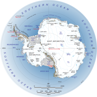
The geography of Antarctica is dominated by its south polar location and, thus, by ice. The Antarctic continent, located in the Earth's southern hemisphere, is centered asymmetrically around the South Pole and largely south of the Antarctic Circle. It is washed by the Southern Ocean or, depending on definition, the southern Pacific, Atlantic, and Indian Oceans. It has an area of more than 14.2 million km2. Antarctica is the largest ice desert in the world.

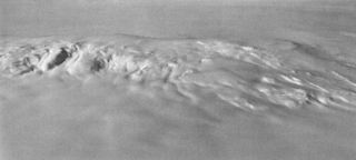
Vinson Massif is a large mountain massif in Antarctica that is 21 km (13 mi) long and 13 km (8 mi) wide and lies within the Sentinel Range of the Ellsworth Mountains. It overlooks the Ronne Ice Shelf near the base of the Antarctic Peninsula. The massif is located about 1,200 kilometres (750 mi) from the South Pole. Vinson Massif was discovered in January 1958 by U.S. Navy aircraft. In 1961, the Vinson Massif was named by the Advisory Committee on Antarctic Names (US-ACAN), after Carl G. Vinson, United States congressman from the state of Georgia, for his support for Antarctic exploration. On November 1, 2006, US-ACAN declared Mount Vinson and Vinson Massif to be separate entities. Vinson Massif lies within the unrecognised Chilean claim under the Antarctic Treaty System.

The Ellsworth Mountains are the highest mountain ranges in Antarctica, forming a 350 km (217 mi) long and 48 km (30 mi) wide chain of mountains in a north to south configuration on the western margin of the Ronne Ice Shelf in Marie Byrd Land. They are bisected by Minnesota Glacier to form the Sentinel Range to the north and the Heritage Range to the south. The former is by far the higher and more spectacular with Mount Vinson constituting the highest point on the continent. The mountains are located within the Chilean Antarctic territorial claim but outside of the Argentinian and British ones.

Marie Byrd Land (MBL) is an unclaimed region of Antarctica. With an area of 1,610,000 km2 (620,000 sq mi), it is the largest unclaimed territory on Earth. It was named after the wife of American naval officer Richard E. Byrd, who explored the region in the early 20th century.

Mount Hampton is a shield volcano with a circular ice-filled caldera. It is a twin volcano with Whitney Peak to the northwest and has erupted phonolite rocks. It is the northernmost of the volcanoes which comprise the Executive Committee Range in Marie Byrd Land, Antarctica and was active during the Miocene.

Mount Moulton is a 40-kilometre-long (25 mi) complex of ice-covered shield volcanoes, standing 25 kilometres (16 mi) east of Mount Berlin in the Flood Range, Marie Byrd Land, Antarctica. It is named for Richard S. Moulton, chief dog driver at West Base. The volcano is of Pliocene age and is presently inactive.

Mount Murphy is a massive, snow-covered mountain with steep, rocky slopes rising to 2,505 metres (8,219 ft) in Marie Byrd Land, Antarctica. It is directly south of Bear Peninsula and is bounded by Smith Glacier, Pope Glacier and Haynes Glacier. Volcanic activity began in the Miocene with the eruption of basaltic and trachytic lava. Volcanism on the slopes of the volcano resumed much later during the Pleistocene, with a parasitic cone having been K–Ar dated to 0.9 million years old.

Mount Takahe is a 3,460-metre-high (11,350 ft) snow-covered shield volcano in Marie Byrd Land, Antarctica, 200 kilometres (120 mi) from the Amundsen Sea. It is a c. 30-kilometre-wide (19 mi) mountain with parasitic vents and a caldera up to 8 kilometres (5 mi) wide. Most of the volcano is formed by trachytic lava flows, but hyaloclastite is also found. Snow, ice, and glaciers cover most of Mount Takahe. With a volume of 780 km3 (200 cu mi), it is a massive volcano; the parts of the edifice that are buried underneath the West Antarctic Ice Sheet are probably even larger. It is part of the West Antarctic Rift System along with eighteen other known volcanoes.

Toney Mountain is an elongated snow-covered shield volcano, 38 nautical miles long and rising to 3,595 metres (11,795 ft) at Richmond Peak, located 35 nautical miles southwest of Kohler Range in Marie Byrd Land, Antarctica.

Mount Waesche is a mountain of volcanic origin at the southern end of the Executive Committee Range in Marie Byrd Land, Antarctica. It is 3,292 metres high, and stands 20 kilometres southwest of Mount Sidley, the highest volcano in Antarctica. The mountain lies southwest of the Chang Peak caldera and is largely covered with snow and glaciers, but there are rock exposures on the southern and southwestern slopes.

Crary Mountains are a group of ice-covered volcanoes in Marie Byrd Land, Antarctica. They consist of two or three shield volcanoes, named Mount Rees, Mount Steere and Mount Frakes, which developed during the course of the Miocene and Pliocene and last erupted about 30,000-40,000 years ago. The first two volcanoes are both heavily incised by cirques, while Mount Frakes is better preserved and has a 4 kilometres (2.5 mi) wide caldera at its summit. Boyd Ridge is another part of the mountain range and lies southeast of Mount Frakes; it might be the emergent part of a platform that underlies the mountain range.

West Antarctica, or Lesser Antarctica, one of the two major regions of Antarctica, is the part of that continent that lies within the Western Hemisphere, and includes the Antarctic Peninsula. It is separated from East Antarctica by the Transantarctic Mountains and is covered by the West Antarctic Ice Sheet. It lies between the Ross Sea, and the Weddell Sea. It may be considered a giant peninsula, stretching from the South Pole towards the tip of South America.

The Fosdick Mountains are an east–west trending mountain range with marked serrate outlines, standing along the south side of Balchen Glacier at the head of Block Bay, in the Ford Ranges of Marie Byrd Land, Antarctica.

Mount Anderson is a high mountain in the northern part of the Sentinel Range in Ellsworth Mountains, Antarctica. Probuda Ridge is trending northeast of the peak, and Embree Glacier and Ellen Glacier's tributary Fonfon Glacier drain its northeastern and eastern slopes respectively. It is part of the same massif as Mount Bentley and Mount Sisu.
Buggisch Peak is a peak rising to 1,445 metres (4,740 ft), 1 nautical mile (2 km) southwest of Lester Peak, Edson Hills, in the Heritage Range, Ellsworth Mountains, Marie Byrd Land. It was mapped by the United States Geological Survey from surveys and from U.S. Navy aerial photographs, 1961–66, and named by the Advisory Committee on Antarctic Names after Werner Buggisch, a German member of the field party with the United States Antarctic Research Program Ellsworth Mountains Expedition, 1979–80, led by Gerald F. Webers.

Mount Gardner is a mountain, 4,587 metres (15,050 ft) high, standing 1.5 nautical miles (3 km) west of Mount Tyree in the west-central part of the Sentinel Range, in the Ellsworth Mountains of Antarctica. It surmounts Patton Glacier to the northeast.

The Long Gables are prominent twin peaks, with heights of 4,150 and 4,110 metres, joined by a col, with the lower rock exposures being in the form of steep buttresses. The peaks rise from the main ridge of the Sentinel Range, Ellsworth Mountains, Antarctica between Mount Anderson and Mount Viets. They surmount Burdenis Glacier to the southeast, Gerila Glacier to the east and Fonfon Glacier to the northeast.

Aster Glacier is an Antarctic glacier descending the east slope of Craddock Massif and flowing between Elfring Peak and Willis Ridge to Thomas Glacier in the Sentinel Range, Ellsworth Mountains in Antarctica. It was named by the Advisory Committee on Antarctic Names in 2006, after Richard Aster, Professor of Geophysics and Department Head of Geosciences at Colorado State University, whose research in Antarctica includes volcanological studies at the Mount Erebus volcano observatory on Ross Island, glaciological, oceanic, and tectonic seismic source studies, seismic tomography, ice shelf studies, and the coupling of solid Earth geophysics and Antarctic ice sheet evolution.
The Marie Byrd Land Volcanic Province is a volcanic field in northern Marie Byrd Land of West Antarctica, consisting of over 18 large shield volcanoes, 30 small volcanic centres and possibly many more centres buried under the West Antarctic Ice Sheet. It overlies a 500 km (310 mi) wide and 800 km (500 mi) long dome that has formed as a result of fault blocking within the West Antarctic Rift System.

Mount Petras is a mountain in Antarctica. It consists of volcanic rocks, most of Cretaceous age but there is also an Eocene-Oligocene volcanic system that may have been emplaced inside of thin ice. It is part of the Marie Byrd Land Volcanic Province and is its oldest volcano.


