List of mountains of Queen Maud Land

Last updated

Jokulkyrkja Mountain seen from the east. The summit is behind what seems like the highest peak to the right. Jokolkyrkja.jpg
Jøkulkyrkja Mountain seen from the east. The summit is behind what seems like the highest peak to the right.

This list of mountains of Queen Maud Land contains mountains with a registered elevation of higher than 2000 metres (6561 feet) above sea level. The availability of accurate data for this region is limited, making the list both incomplete and inaccurate. Prominence data is generally not available, and the list includes rock formations such as mountain peaks, ridges, nunataks, cliffs and crags. Ice domes are not included in the list.

With an elevation of 3,148 metres (10,328 ft),s Jøkulkyrkja Mountain is the highest mountain of Queen Maud Land. [1] According to the United States Geological Survey (USGS) database Geographic Names Information System (GNIS) and other sources, several summits in the Sør Rondane Mountains are registered with higher elevation, including Isachsen Mountain (3,425 metres), [2] Devold Peak (3,280 meters), [3] Kjelbotn Peak (3,210 meters), [4] Bond Peaks (3,180 meters) [5] and Mount Widerøe (3,180 meters). [6] According to Belgian sources [7] and Norwegian topographic maps, [8] the highest elevation of Sør Rondane Mountains is just below 3000 m.a.s.l.

NameElevation (meters)RangeCoordinates GNIS ID SCAR ID
Devold Peak 3280 [9] Sør Rondane Mountains 72°22′S27°03′E / 72.367°S 27.050°E / -72.367; 27.050 3812 3595
Kjelbotn Peak 3210 [9] Sør Rondane Mountains 72°20′S26°50′E / 72.333°S 26.833°E / -72.333; 26.833 8022 7598
Bond Peaks 3180 [9] [10] Sør Rondane Mountains 72°15′S25°35′E / 72.250°S 25.583°E / -72.250; 25.583 1629 1562
Jøkulkyrkja Mountain 3148 [1] Mühlig-Hofmann Mountains 71°53′S06°42′E / 71.883°S 6.700°E / -71.883; 6.700 7624 7207
Kyrkjeskipet Peak 3083 [11] Mühlig-Hofmann Mountains 71°52′S06°46′E / 71.867°S 6.767°E / -71.867; 6.767 8325 7972
Sandeggtind Peak 3053 [10] Conrad Mountains 71°51′S09°45′E / 71.850°S 9.750°E / -71.850; 9.750 13239 12696
Gessner Peak 3020 [9] [10] Mühlig-Hofmann Mountains 71°46′S06°54′E / 71.767°S 6.900°E / -71.767; 6.900 5629 5283
Mount Widerøe 2994 [10] Sør Rondane Mountains 72°09′S23°14′E / 72.150°S 23.233°E / -72.150; 23.233 16564 16012
Kubus Mountain 2985 [9] [10] Filchner Mountains 71°58′S07°20′E / 71.967°S 7.333°E / -71.967; 7.333 8269 7882
Gløymdehorten Nunatak 2980 [10] Hoel Mountains 72°07′S12°12′E / 72.117°S 12.200°E / -72.117; 12.200 5759 5410
Komsa Mountain 2960 [9] Sør Rondane Mountains 72°08′S25°19′E / 72.133°S 25.317°E / -72.133; 25.317 8129 7726
Salen Mountain 2950 [9] Sør Rondane Mountains 72°08′S25°28′E / 72.133°S 25.467°E / -72.133; 25.467 13175 12619
Zwiesel Mountain 2947 [10] Wohlthat Mountains 71°43′S12°07′E / 71.717°S 12.117°E / -71.717; 12.117 16979 16545
Habermehl Peak 2945 [9] [10] Mühlig-Hofmann Mountains 71°49′S06°54′E / 71.817°S 6.900°E / -71.817; 6.900 6185 5834
Ulvetanna Peak 2931 [10] Drygalski Mountains 71°51′S08°20′E / 71.850°S 8.333°E / -71.850; 8.333 15762 15176
Gneiskopf Peak 2930 [9] Südliche Petermann Range 71°56′S12°05′E / 71.933°S 12.083°E / -71.933; 12.083 5766 5423
Håhellerskarvet 2910 [9] [10] Mühlig-Hofmann Mountains 71°57′S06°10′E / 71.950°S 6.167°E / -71.950; 6.167 6211 5862
Klevekåpa Mountain 2910 [9] [10] Filchner Mountains 72°01′S07°37′E / 72.017°S 7.617°E / -72.017; 7.617 8045 7625
Klevetind Peak 2910 [9] [10] Filchner Mountains 71°59′S07°37′E / 71.983°S 7.617°E / -71.983; 7.617 8046 7626
Mount Neustruyev 2900 [9] Südliche Petermann Range 71°51′18″S12°14′00″E / 71.85500°S 12.23333°E / -71.85500; 12.23333 10632 10194
Taborovskiy Peak 2895 [9] [10] Humboldt Mountains 71°48′06″S11°35′30″E / 71.80167°S 11.59167°E / -71.80167; 11.59167 14956 14371
Hamartind Peak 2885 [10] Sverdrup Mountains 72°33′S00°39′E / 72.550°S 0.650°E / -72.550; 0.650 6270 5922
Skeidsnutane Peaks 2885 [10] Humboldt Mountains 71°53′S11°35′E / 71.883°S 11.583°E / -71.883; 11.583 13939 13396
Granitnaya Mountain 2880 [9] Wohlthat Mountains 72°07′30″S11°37′30″E / 72.12500°S 11.62500°E / -72.12500; 11.62500 5947 5598
Håhelleregga Ridge 2875 [10] Mühlig-Hofmann Mountains 71°53′S06°00′E / 71.883°S 6.000°E / -71.883; 6.000 6209 5860
Dufek Mountain 2873 [10] Sør Rondane Mountains 72°13′S24°42′E / 72.217°S 24.700°E / -72.217; 24.700 4142 3932
Mount Walnum 2870 [9] Sør Rondane Mountains 72°04′30″S24°06′00″E / 72.07500°S 24.10000°E / -72.07500; 24.10000 16237 15701
Skarsholen 2860 [10] Humboldt Mountains 71°47′S11°30′E / 71.783°S 11.500°E / -71.783; 11.500 13380
Arden 2850 [10] Sør Rondane Mountains 72°15′S24°55′E / 72.250°S 24.917°E / -72.250; 24.917 475
Mount Nikolayev 2850 [9] [10] Südliche Petermann Range 71°43′48″S12°26′30″E / 71.73000°S 12.44167°E / -71.73000; 12.44167 10713 10270
Mount Bjerke 2840 [9] [10] Conrad Mountains 71°58′S09°42′E / 71.967°S 9.700°E / -71.967; 9.700 1432 1384
Larsen Cliffs 2835 [10] Mühlig-Hofmann Mountains 71°56′S06°55′E / 71.933°S 6.917°E / -71.933; 6.917 8529 8146
Smolenskaya Mountain 2835 [10] Südliche Petermann Range 71°52′06″S12°21′30″E / 71.86833°S 12.35833°E / -71.86833; 12.35833 14098 13550
Isingen Mountain 2830 [10] Sverdrup Mountains 72°23′S01°06′E / 72.383°S 1.100°E / -72.383; 1.100 7381 6961
Mount Skarshovden 2830 [9] [10] Humboldt Mountains 71°47′S11°37′E / 71.783°S 11.617°E / -71.783; 11.617 13924 13381
Graben Horn 2830 [10] Wohlthat Mountains 71°48′S12°02′E / 71.800°S 12.033°E / -71.800; 12.033 5912 5562
Balchen Mountain 2820 [9] Sør Rondane Mountains 72°02′S27°30′E / 72.033°S 27.500°E / -72.033; 27.500 885 806
Mount Mirotvortsev 2815 [10] Südliche Petermann Range 71°50′18″S12°18′00″E / 71.83833°S 12.30000°E / -71.83833; 12.30000 10058 9650
Mount Khmyznikov 2805 [10] Humboldt Mountains 71°51′54″S11°39′30″E / 71.86500°S 11.65833°E / -71.86500; 11.65833 7910 7499
Ritscher Peak 2791 [10] Gruber Mountains 71°25′S13°19′E / 71.417°S 13.317°E / -71.417; 13.317 12687 12185
Rogers Peaks 2788 [10] Sør Rondane Mountains 72°18′00″S24°23′30″E / 72.30000°S 24.39167°E / -72.30000; 24.39167 12818 12291
Hålisstonga Peak 2780 [9] [10] Kurze Mountains 72°02′S08°56′E / 72.033°S 8.933°E / -72.033; 8.933 6243 5896
Klevekampen Mountain 2780 [10] Filchner Mountains 71°57′S07°40′E / 71.950°S 7.667°E / -71.950; 7.667 8044 7624
Snønutane Peaks 2780 [12] Mühlig-Hofmann Mountains 72°06′S04°50′E / 72.100°S 4.833°E / -72.100; 4.833 14124 13580
Kvithø Peak 2775 [10] Sverdrup Mountains 72°29′S01°14′E / 72.483°S 1.233°E / -72.483; 1.233 8309 7954
Sloknuten Peak 2765 [9] [10] Mühlig-Hofmann Mountains 72°02′S04°52′E / 72.033°S 4.867°E / -72.033; 4.867 14028 13491
Mount Hochlin 2760 [9] [10] Mühlig-Hofmann Mountains 72°05′S04°03′E / 72.083°S 4.050°E / -72.083; 4.050 6839 6447
Skruvestikka Nunatak 2760 [10] Payer Mountains 72°11′30″S14°28′00″E / 72.19167°S 14.46667°E / -72.19167; 14.46667 13985 13444
Botnfjellet Mountain 2750 [9] [10] Humboldt Mountains 71°45′S11°25′E / 71.750°S 11.417°E / -71.750; 11.417 1720 1646
Isachsen Mountain 2750 [10] Sør Rondane Mountains 72°16′S26°30′E / 72.267°S 26.500°E / -72.267; 26.500 7366 6939
Klumpen 2750 [10] Sør Rondane Mountains 72°08′00″S25°08′30″E / 72.13333°S 25.14167°E / -72.13333; 25.14167 7641
Majoren 2750 [10] Sør Rondane Mountains 72°16′48″S26°31′30″E / 72.28000°S 26.52500°E / -72.28000; 26.52500 8884
Mefjell Mountain 2750 [10] Sør Rondane Mountains 72°05′S25°00′E / 72.083°S 25.000°E / -72.083; 25.000 9798 9380
Viking Heights 2750 [10] Sør Rondane Mountains 72°04′S23°10′E / 72.067°S 23.167°E / -72.067; 23.167 16062 15511
Setenuten Peak 2745 [9] [10] Mühlig-Hofmann Mountains 72°03′S04°45′E / 72.050°S 4.750°E / -72.050; 4.750 13598 13049
Svartnupen Peak 2745 [10] Kurze Mountains 71°55′S08°54′E / 71.917°S 8.900°E / -71.917; 8.900 14886 14292
Altartavla 2742 [10] Humboldt Mountains 71°40′S11°29′E / 71.667°S 11.483°E / -71.667; 11.483 271
Puppa 2740 [10] Sør Rondane Mountains 72°11′42″S25°00′00″E / 72.19500°S 25.00000°E / -72.19500; 25.00000 11710
Rakebosten Ridge 2737 [10] Filchner Mountains 71°56′S07°12′E / 71.933°S 7.200°E / -71.933; 7.200 12315 11837
Trollslottet Mountain 2737 [10] Filchner Mountains 71°56′S07°12′E / 71.933°S 7.200°E / -71.933; 7.200 15573 14986
Langfloget Cliff 2730 [12] Mühlig-Hofmann Mountains 72°07′S04°25′E / 72.117°S 4.417°E / -72.117; 4.417 8459 8459
Skeidshovden Mountain 2730 [9] [10] Wohlthat Mountains 72°08′12″S11°31′00″E / 72.13667°S 11.51667°E / -72.13667; 11.51667 13936 13393
Mount Valikhanov 2730 [10] Südliche Petermann Range 71°49′12″S12°15′00″E / 71.82000°S 12.25000°E / -71.82000; 12.25000 15848 15281
Luncke Range 2727 [10] Sør Rondane Mountains 72°02′30″S24°36′00″E / 72.04167°S 24.60000°E / -72.04167; 24.60000 9138 8725
Breplogen Mountain 2725 [9] [10] Mühlig-Hofmann Mountains 71°54′S05°27′E / 71.900°S 5.450°E / -71.900; 5.450 1910 1833
Mount Flånuten 2725 [9] [10] Humboldt Mountains 71°46′S11°15′E / 71.767°S 11.250°E / -71.767; 11.250 4993 4680
Kinntanna Peak 2725 [9] Drygalski Mountains 71°53′S08°22′E / 71.883°S 8.367°E / -71.883; 8.367 7980 7544
Skeidshornet Peak 2725 [9] [10] Wohlthat Mountains 71°51′S12°00′E / 71.850°S 12.000°E / -71.850; 12.000 13935 13392
Vørterkaka Nunatak 2725 [10] Sør Rondane Mountains 72°28′30″S27°58′00″E / 72.47500°S 27.96667°E / -72.47500; 27.96667 16136 15590
Roots Heights 2722 [10] Sverdrup Mountains 72°35′S00°26′E / 72.583°S 0.433°E / -72.583; 0.433 12885 12350
Bogbrerinden 2720 [10] Sør Rondane Mountains 72°16′18″S25°25′30″E / 72.27167°S 25.42500°E / -72.27167; 25.42500 1517
Pervomayskaya Peak 2720 [10] Humboldt Mountains 71°46′42″S11°40′30″E / 71.77833°S 11.67500°E / -71.77833; 11.67500 11646 11140
Høgsaetet Mountain 2717 [10] Borg Massif 72°35′S03°24′W / 72.583°S 3.400°W / -72.583; -3.400 6871 6481
Mount Solov'yev 2715 [9] Westliche Petermann Range 71°41′30″S12°20′00″E / 71.69167°S 12.33333°E / -71.69167; 12.33333 14180 13647
Paalnibba 2711 [10] Heimefront Range 74°45′42″S11°36′30″W / 74.76167°S 11.60833°W / -74.76167; -11.60833 10803
Tambovskaya Peak 2709 [10] Westliche Petermann Range 71°40′30″S12°20′30″E / 71.67500°S 12.34167°E / -71.67500; 12.34167 14981 14412
Shatskiy Hill 2705 [9] Weyprecht Mountains 72°02′S13°23′E / 72.033°S 13.383°E / -72.033; 13.383 13669 13106
Risemedet Mountain 2704 [10] Gjelsvik Mountains 72°03′S03°10′E / 72.050°S 3.167°E / -72.050; 3.167 12676 12174
Winsnesfjellet 2702 [10] Sør Rondane Mountains 72°06′00″S25°42′30″E / 72.10000°S 25.70833°E / -72.10000; 25.70833 5448
Aurdalsegga Ridge 2700 [10] Südliche Petermann Range 71°44′S12°23′E / 71.733°S 12.383°E / -71.733; 12.383 718 631
Hovdeknattane Rocks 2700 [10] Wohlthat Mountains 72°07′S11°38′E / 72.117°S 11.633°E / -72.117; 11.633 7075 6662
Mount Grytøyr 2695 [9] [10] Mühlig-Hofmann Mountains 72°00′S04°30′E / 72.000°S 4.500°E / -72.000; 4.500 6104 5745
Skanseryggen 2694 [10] Sør Rondane Mountains 72°11′06″S25°10′30″E / 72.18500°S 25.17500°E / -72.18500; 25.17500 13373
Mount Bolle 2685 [9] Mühlig-Hofmann Mountains 71°54′S06°50′E / 71.900°S 6.833°E / -71.900; 6.833 1607 1545
Skorvetangen Spur 2680 [10] Mühlig-Hofmann Mountains 72°03′S05°20′E / 72.050°S 5.333°E / -72.050; 5.333 13976 13440
Petrellfjellet 2678 [10] Mühlig-Hofmann Mountains 71°59′S04°39′E / 71.983°S 4.650°E / -71.983; 4.650 11686 11185
Terningen Peak 2678 [10] Gjelsvik Mountains 72°11′S02°45′E / 72.183°S 2.750°E / -72.183; 2.750 15129 14547
Glopenesranen Nunatak 2675 [10] Conrad Mountains 72°08′S10°00′E / 72.133°S 10.000°E / -72.133; 10.000 5753 5400
Heikampen Peak 2675 [10] Sverdrup Mountains 72°28′S00°40′E / 72.467°S 0.667°E / -72.467; 0.667 6572 6187
Klakemulen 2675 [10] Sør Rondane Mountains 72°06′30″S26°00′00″E / 72.10833°S 26.00000°E / -72.10833; 26.00000 1644
Kvalfinnen Ridge 2670 [9] Sør Rondane Mountains 72°12′30″S26°37′00″E / 72.20833°S 26.61667°E / -72.20833; 26.61667 8296 7935
Rivenæsnuten 2670 [10] Sivorgfjella 74°51′S11°22′W / 74.850°S 11.367°W / -74.850; -11.367 12192
Trollryggen 2670 [10] Sør Rondane Mountains 72°40′48″S27°00′00″E / 72.68000°S 27.00000°E / -72.68000; 27.00000 14985
Steinfila Nunatak 2665 [10] Payer Mountains 72°12′S14°22′E / 72.200°S 14.367°E / -72.200; 14.367 14539 13986
Tussenobba Peak 2665 [9] Mühlig-Hofmann Mountains 72°00′S06°16′E / 72.000°S 6.267°E / -72.000; 6.267 15684 15100
Portnipa Peak 2664 [10] Gjelsvik Mountains 72°14′S02°23′E / 72.233°S 2.383°E / -72.233; 2.383 11970 11495
Sandhø Heights 2664 [10] Conrad Mountains 71°51′S09°48′E / 71.850°S 9.800°E / -71.850; 9.800 13247 12706
Von Essen Mountain 2664 [10] Gjelsvik Mountains 72°16′S02°23′E / 72.267°S 2.383°E / -72.267; 2.383 16124 15580
Mount Nils Larsen 2663 [10] Sør Rondane Mountains 72°15′S22°46′E / 72.250°S 22.767°E / -72.250; 22.767 10729 10274
Mellomfjellet 2660 [10] Sør Rondane Mountains 72°13′42″S25°51′00″E / 72.22833°S 25.85000°E / -72.22833; 25.85000 9407
Poulssonhamaren 2660 [10] Heimefront Range 74°47′48″S11°29′00″W / 74.79667°S 11.48333°W / -74.79667; -11.48333 11529
Breskilkampen 2656 [10] Sør Rondane Mountains 72°14′00″S25°59′30″E / 72.23333°S 25.99167°E / -72.23333; 25.99167 1834
Hålisrimen Peak 2655 [9] [10] Kurze Mountains 72°00′S08°46′E / 72.000°S 8.767°E / -72.000; 8.767 6242 5895
Mount Krüger 2655 [9] [10] Sverdrup Mountains 72°36′S00°56′E / 72.600°S 0.933°E / -72.600; 0.933 8255 7862
Holtanna Peak 2650 [9] [10] Drygalski Mountains 71°54′S08°22′E / 71.900°S 8.367°E / -71.900; 8.367 6923 6538
Mjellbresåtene 2650 [10] Sør Rondane Mountains 72°20′00″S26°00′30″E / 72.33333°S 26.00833°E / -72.33333; 26.00833 4579
Remplingen Peak 2650 [9] Mühlig-Hofmann Mountains 72°05′S04°17′E / 72.083°S 4.283°E / -72.083; 4.283 12516 12033
Snøskalkhausen Peak 2650 [9] Weyprecht Mountains 72°02′S13°12′E / 72.033°S 13.200°E / -72.033; 13.200 14127 13583
Imingfjellet 2645 [10] Sør Rondane Mountains 72°17′30″S26°07′00″E / 72.29167°S 26.11667°E / -72.29167; 26.11667 12508
Dekefjellet Mountain 2640 [10] Weyprecht Mountains 71°58′S13°25′E / 71.967°S 13.417°E / -71.967; 13.417 3685 3486
Egil Peak 2640 [9] [10] Sverdrup Mountains 72°24′S01°17′E / 72.400°S 1.283°E / -72.400; 1.283 4356 4110
Gjeruldsenhøgda 2640 [10] Orvin Mountains 71°59′S10°49′E / 71.983°S 10.817°E / -71.983; 10.817 5357
Høgesyn 2640 [10] Sør Rondane Mountains 72°05′S24°58′E / 72.083°S 24.967°E / -72.083; 24.967 6470
Kamskaya Peak 2640 [10] Weyprecht Mountains 71°57′30″S13°26′00″E / 71.95833°S 13.43333°E / -71.95833; 13.43333 7745 7340
Kazanskaya Mountain 2640 [10] Weyprecht Mountains 71°59′S13°16′E / 71.983°S 13.267°E / -71.983; 13.267 7799 7403
Malysh Mountain 2640 [9] Wohlthat Mountains 72°09′S11°24′E / 72.150°S 11.400°E / -72.150; 11.400 9329 8916
Snøskalkegga Ridge 2640 [10] Weyprecht Mountains 71°59′S13°15′E / 71.983°S 13.250°E / -71.983; 13.250 14126 13582
Vavilov Hill 2640 [9] Weyprecht Mountains 72°02′12″S13°13′00″E / 72.03667°S 13.21667°E / -72.03667; 13.21667 15913 15351
Slettefjellet 2638 [10] Mühlig-Hofmann Mountains 71°45′S06°53′E / 71.750°S 6.883°E / -71.750; 6.883 14019 13482
Mount Bergersen 2636 [10] Sør Rondane Mountains 72°04′S25°55′E / 72.067°S 25.917°E / -72.067; 25.917 1264 1217
Linnormegget Hill 2635 [10] Payer Mountains 72°08′S14°27′E / 72.133°S 14.450°E / -72.133; 14.450 8871 8483
Mount Deryugin 2635 [9] Humboldt Mountains 71°51′S11°20′E / 71.850°S 11.333°E / -71.850; 11.333 3766 3557
Ryghnuten 2630 [10] Sivorgfjella 74°50′18″S11°26′00″W / 74.83833°S 11.43333°W / -74.83833; -11.43333 12555
Birgerhøgda 2625 [10] Sør Rondane Mountains 72°04′48″S25°53′30″E / 72.08000°S 25.89167°E / -72.08000; 25.89167 7909
Oppkuven Peak 2625 [10] Sverdrup Mountains 72°36′S00°25′E / 72.600°S 0.417°E / -72.600; 0.417 11125 10657
Ladfjella 2620 [10] Kirwan Escarpment 74°06′S07°45′W / 74.100°S 7.750°W / -74.100; -7.750 7995
Müller Crest 2620 [9] [10] Payer Mountains 72°11′S08°07′E / 72.183°S 8.117°E / -72.183; 8.117 10377 9951
Ormeryggen 2620 [10] Kirwan Escarpment 72°04′S14°32′E / 72.067°S 14.533°E / -72.067; 14.533 11154 10682
Keipen 2610 [10] Payer Mountains 72°19′00″S25°48′30″E / 72.31667°S 25.80833°E / -72.31667; 25.80833 7416
Langbogfjellet 2610 [10] Sør Rondane Mountains 72°13′12″S25°41′30″E / 72.22000°S 25.69167°E / -72.22000; 25.69167 8085
Skavlhø Mountain 2610 [9] [10] Sør Rondane Mountains 72°01′48″S14°29′30″E / 72.03000°S 14.49167°E / -72.03000; 14.49167 13929 13387
Raudberget 2606 [10] Borg Massif 72°38′S03°30′W / 72.633°S 3.500°W / -72.633; -3.500 12373 11896
Halsknappane Hills 2600 [10] Wohlthat Mountains 72°04′S06°02′E / 72.067°S 6.033°E / -72.067; 6.033 6262 5915
Malmrusta 2600 [10] Mühlig-Hofmann Mountains 74°43′54″S11°26′00″W / 74.73167°S 11.43333°W / -74.73167; -11.43333 8900
Mount Skeidskneet 2600 [9] [10] Sivorgfjella 71°53′S11°57′E / 71.883°S 11.950°E / -71.883; 11.950 13938 13395
Spiret Peak 2594 [10] Borg Massif 72°31′S03°38′W / 72.517°S 3.633°W / -72.517; -3.633 14387 13834
Bjørnnutane 2590 [10] XU-fjella 74°37′S10°00′W / 74.617°S 10.000°W / -74.617; -10.000 1388
Gårenevslottet 2590 [10] Payer Mountains 71°59′S14°40′E / 71.983°S 14.667°E / -71.983; 14.667 5134
Mount Victor 2590 [9] Belgica Mountains 72°36′S31°16′E / 72.600°S 31.267°E / -72.600; 31.267 16027 15487
Sørsteinen 2580 [10] Fimbulheimen 72°21′S15°58′E / 72.350°S 15.967°E / -72.350; 15.967 13702
Høgfonna Mountain 2579 [10] Borg Massif 72°45′S03°33′W / 72.750°S 3.550°W / -72.750; -3.550 6865 6472
Médåsen 2575 [10] Humboldt Mountains 71°51′S11°49′E / 71.850°S 11.817°E / -71.850; 11.817 9364
Mount Van Mieghem 2572 [13] Belgica Mountains 72°36′S31°14′E / 72.600°S 31.233°E / -72.600; 31.233 15883 15304
Høgskolten 2565 [10] Orvin Mountains 72°24′06″S27°53′00″E / 72.40167°S 27.88333°E / -72.40167; 27.88333 6490
Mørkenatten Peak 2565 [10] Sør Rondane Mountains 71°51′S10°34′E / 71.850°S 10.567°E / -71.850; 10.567 10256 9848
Høgskavlnasen Point 2564 [10] Borg Massif 72°42′S03°44′W / 72.700°S 3.733°W / -72.700; -3.733 6874 6484
Mount Solvay 2564 [13] Belgica Mountains 72°34′S31°23′E / 72.567°S 31.383°E / -72.567; 31.383 14185 13652
Kvithamaren Cliff 2560 [10] Mühlig-Hofmann Mountains 71°59′S05°03′E / 71.983°S 5.050°E / -71.983; 5.050 8307 7953
Mount Ramenskiy 2560 [9] Südliche Petermann Range 71°46′S12°33′E / 71.767°S 12.550°E / -71.767; 12.550 12332 11855
Sarkofagen Mountain 2560 [10] Mühlig-Hofmann Mountains 72°10′30″S16°45′00″E / 72.17500°S 16.75000°E / -72.17500; 16.75000 13301 12744
Zhil'naya Mountain 2560 [9] Südliche Petermann Range 71°40′S12°38′E / 71.667°S 12.633°E / -71.667; 12.633 16943 16490
Storknolten Peak 2555 [10] Filchner Mountains 72°11′S08°03′E / 72.183°S 8.050°E / -72.183; 8.050 14649 14091
Dungane Peaks 2550 [10] Payer Mountains 72°13′12″S23°57′00″E / 72.22000°S 23.95000°E / -72.22000; 23.95000 4169 3962
Chervov Peak 2550 [9] Shcherbakov Range 71°50′S10°33′E / 71.833°S 10.550°E / -71.833; 10.550 2715 2598
Ormehausen Peak 2550 [10] Sør Rondane Mountains 72°01′S14°37′E / 72.017°S 14.617°E / -72.017; 14.617 11153 10681
Brattingen 2546 [10] Sør Rondane Mountains 72°16′48″S25°54′00″E / 72.28000°S 25.90000°E / -72.28000; 25.90000 1779
Domen Butte 2545 [10] Borg Massif 72°43′S03°50′W / 72.717°S 3.833°W / -72.717; -3.833 3963 3753
Isdalsegga Ridge 2540 [10] Südliche Petermann Range 71°43′S12°34′E / 71.717°S 12.567°E / -71.717; 12.567 737 6949
Pinegin Peak 2540 [10] Südliche Petermann Range 71°44′06″S12°33′30″E / 71.73500°S 12.55833°E / -71.73500; 12.55833 11787 11282
Mount Severtsev 2540 [9] Südliche Petermann Range 71°43′S12°37′E / 71.717°S 12.617°E / -71.717; 12.617 13605 13055
Høgryggen 2535 [10] Sør Rondane Mountains 72°12′30″S23°46′30″E / 72.20833°S 23.77500°E / -72.20833; 23.77500 6480
Festninga Mountain 2535 [9] Mühlig-Hofmann Mountains 72°07′S03°42′E / 72.117°S 3.700°E / -72.117; 3.700 4858 4555
Mount Ruhnke 2535 [9] Mühlig-Hofmann Mountains 72°05′S03°38′E / 72.083°S 3.633°E / -72.083; 3.633 13018 12471
Mount Boë 2534 [13] Belgica Mountains 72°35′S31°19′E / 72.583°S 31.317°E / -72.583; 31.317 1582 1514
Mjøllføykje Bluff 2534 [10] Kirwan Escarpment 73°32′S03°45′W / 73.533°S 3.750°W / -73.533; -3.750 10102 9699
Mount Van der Essen 2531 [13] Belgica Mountains 72°35′S31°23′E / 72.583°S 31.383°E / -72.583; 31.383 15867 15296
Vendehø Heights 2529 [10] Sverdrup Mountains 72°18′S01°27′E / 72.300°S 1.450°E / -72.300; 1.450 15940 15376
Niels Peak 2525 [9] [10] Gagarin Mountains 71°58′S09°22′E / 71.967°S 9.367°E / -71.967; 9.367 10708 10256
Mount Kolodkin 2525 [9] Südliche Petermann Range 71°45′00″S12°37′30″E / 71.75000°S 12.62500°E / -71.75000; 12.62500 8122 7711
Krasheninnikov Peak 2525 [9] Südliche Petermann Range 71°41′00″S12°40′30″E / 71.68333°S 12.67500°E / -71.68333; 12.67500 8200 7808
Mount Zuckerhut 2525 [9] Gruber Mountains 71°25′S13°26′E / 71.417°S 13.433°E / -71.417; 13.433 13964 16532
Pilarryggen 2523 [10] Borg Massif 72°43′S03°56′W / 72.717°S 3.933°W / -72.717; -3.933 11765 11257
Sanengenrusta 2520 [10] Sivorgfjella 74°42′S11°21′W / 74.700°S 11.350°W / -74.700; -11.350 12721
Sørfløya 2520 [10] Kirwan Escarpment 74°11′00″S06°26′30″W / 74.18333°S 6.44167°W / -74.18333; -6.44167 13684
Mount Yesenin 2520 [9] Payer Mountains 72°03′S14°26′E / 72.050°S 14.433°E / -72.050; 14.433 16878 16370
Gavlen Ridge 2519 [10] Sverdrup Mountains 72°38′S00°26′E / 72.633°S 0.433°E / -72.633; 0.433 5537 5183
Bakveggen 2515 [10] Sør Rondane Mountains 72°20′54″S25°48′30″E / 72.34833°S 25.80833°E / -72.34833; 25.80833 798
Glitrenosa 2515 [10] Sør Rondane Mountains 72°02′S25°46′E / 72.033°S 25.767°E / -72.033; 25.767 5393
Terletskiy Peak 2515 [10] Orvin Mountains 71°49′24″S10°31′30″E / 71.82333°S 10.52500°E / -71.82333; 10.52500 15121 14538
Røysane Rocks 2513 [10] Sør Rondane Mountains 72°21′18″S22°57′30″E / 72.35500°S 22.95833°E / -72.35500; 22.95833 12988 12438
Mount Rossel 2512 [13] Belgica Mountains 72°36′S31°02′E / 72.600°S 31.033°E / -72.600; 31.033 12921 12387
Brattfjellet 2510 [10] Sør Rondane Mountains 72°27′12″S27°59′00″E / 72.45333°S 27.98333°E / -72.45333; 27.98333 1775
Mount Dzhalil' 2510 [9] Payer Mountains 72°01′48″S14°35′30″E / 72.03000°S 14.59167°E / -72.03000; 14.59167 4232 4011
Festefjell 2508 [10] Sør Rondane Mountains 72°08′36″S25°41′00″E / 72.14333°S 25.68333°E / -72.14333; 25.68333 4552
Deromfjellet 2501 [10] Sør Rondane Mountains 72°04′00″S24°17′30″E / 72.06667°S 24.29167°E / -72.06667; 24.29167 546
Mount Kibal'chich 2500 [9] Payer Mountains 71°56′36″S14°19′00″E / 71.94333°S 14.31667°E / -71.94333; 14.31667 7914 7502
Gårekneet Ridge 2495 [10] Payer Mountains 72°04′S14°48′E / 72.067°S 14.800°E / -72.067; 14.800 5488 5131
Tjuvholene Crags 2495 [9] Mühlig-Hofmann Mountains 71°57′S04°27′E / 71.950°S 4.450°E / -71.950; 4.450 15341 14754
Mount Fukushima 2494 [13] [14] Queen Fabiola Mountains 71°21′S35°37′E / 71.350°S 35.617°E / -71.350; 35.617 5376 5013
Mount Collard 2492 [13] Belgica Mountains 72°38′S31°07′E / 72.633°S 31.117°E / -72.633; 31.117 2964 2839
Mount Hoge 2491 [13] Belgica Mountains 72°35′S31°25′E / 72.583°S 31.417°E / -72.583; 31.417 6863 6471
Store Svarthorn Peak 2488 [10] Mittlere Petermann Range 71°36′S12°33′E / 71.600°S 12.550°E / -71.600; 12.550 14644 14079
Mount Dallmann 2485 [9] Orvin Mountains 71°45′S10°20′E / 71.750°S 10.333°E / -71.750; 10.333 3469 3276
Mount Lahaye 2484 [13] Belgica Mountains 72°36′S31°10′E / 72.600°S 31.167°E / -72.600; 31.167 8389 8018
Enden Point 2483 [10] Kirwan Escarpment 73°37′S04°13′W / 73.617°S 4.217°W / -73.617; -4.217 4512 4250
Ristelen Spur 2480 [10] Mühlig-Hofmann Mountains 71°58′S05°36′E / 71.967°S 5.600°E / -71.967; 5.600 12680 12179
Smalryggen 2480 [10] Sør Rondane Mountains 72°25′24″S27°34′30″E / 72.42333°S 27.57500°E / -72.42333; 27.57500 13510
Mount Launoit 2478 [13] Belgica Mountains 72°34′S31°27′E / 72.567°S 31.450°E / -72.567; 31.450 8585 8187
Mount Gillet 2475 [13] Belgica Mountains 72°34′S31°23′E / 72.567°S 31.383°E / -72.567; 31.383 5682 5325
Nergaard Peak 2475 [9] [10] Gagarin Mountains 72°00′S09°25′E / 72.000°S 9.417°E / -72.000; 9.417 10607 10168
Skappelnabben Spur 2475 [10] Kirwan Escarpment 73°43′S04°33′W / 73.717°S 4.550°W / -73.717; -4.550 13919 13374
Horten Peak 2471 [10] Gjelsvik Mountains 72°04′S03°11′E / 72.067°S 3.183°E / -72.067; 3.183 7035 6630
Mount Brouwer 2466 [13] Belgica Mountains 72°35′S31°26′E / 72.583°S 31.433°E / -72.583; 31.433 2003 1905
Høgekletten 2465 [10] Sør Rondane Mountains 72°27′24″S20°46′00″E / 72.45667°S 20.76667°E / -72.45667; 20.76667 6469
Sistefjell Mountain 2465 [10] Kirwan Escarpment 73°23′S00°44′W / 73.383°S 0.733°W / -73.383; -0.733 13894 13343
Mount Bastei 2460 [9] [10] Gruber Mountains 71°20′S13°30′E / 71.333°S 13.500°E / -71.333; 13.500 1060 985
Urna 2460 [10] Fimbulheimen 72°14′S16°46′E / 72.233°S 16.767°E / -72.233; 16.767 15220
Mundlauga Crags 2455 [9] [10] Drygalski Mountains 71°57′S08°24′E / 71.950°S 8.400°E / -71.950; 8.400 10394 9966
Mount Gaston de Gerlache 2450 [13] Queen Fabiola Mountains 71°44′S35°49′E / 71.733°S 35.817°E / -71.733; 35.817 5511 5154
Nupskåpa Peak 2450 [9] [10] Sverdrup Mountains 72°43′S00°15′E / 72.717°S 0.250°E / -72.717; 0.250 10932 10450
Mount Imbert 2449 [13] Belgica Mountains 72°34′S31°28′E / 72.567°S 31.467°E / -72.567; 31.467 7269 6864
Gandrimen 2435 [10] Sør Rondane Mountains 72°26′S19°19′E / 72.433°S 19.317°E / -72.433; 19.317 5102
Ryvingen Peak 2433 [10] Borg Massif 72°55′S03°30′W / 72.917°S 3.500°W / -72.917; -3.500 13111 12570
Kvaevenutane Peaks 2430 [10] Payer Mountains 71°57′S14°19′E / 71.950°S 14.317°E / -71.950; 14.317 8295 7932
Urfjellgavlen 2430 [10] Kirwan Escarpment 74°06′S05°43′W / 74.100°S 5.717°W / -74.100; -5.717 15215
Vyatskaya Peak 2430 [10] Weyprecht Mountains 71°57′30″S13°32′30″E / 71.95833°S 13.54167°E / -71.95833; 13.54167 16157 15616
Mount Bastin 2429 [13] Belgica Mountains 72°32′S31°15′E / 72.533°S 31.250°E / -72.533; 31.250 1063 987
Mount Loodts 2429 [13] Belgica Mountains 72°32′S31°11′E / 72.533°S 31.183°E / -72.533; 31.183 9016 8629
Mount Paulus 2428 [13] Belgica Mountains 72°37′S31°00′E / 72.617°S 31.000°E / -72.617; 31.000 11460 10974
Mount Kerckhove de Denterghem 2427 [13] Belgica Mountains 72°37′S31°08′E / 72.617°S 31.133°E / -72.617; 31.133 7878 7471
Urnosa Spur 2427 [10] Kirwan Escarpment 73°47′S05°02′W / 73.783°S 5.033°W / -73.783; -5.033 15803 15221
Kallen 2425 [10] Sør Rondane Mountains 72°17′00″S26°15′30″E / 72.28333°S 26.25833°E / -72.28333; 26.25833 7319
Odde Nunatak 2425 [10] Orvin Mountains 72°02′S10°42′E / 72.033°S 10.700°E / -72.033; 10.700 11001 10540
Sløret Rocks 2425 [10] Kirwan Escarpment 73°42′30″S04°17′00″W / 73.70833°S 4.28333°W / -73.70833; -4.28333 14032 13497
Fasettfjellet 2423 [10] Regula Range 72°32′S02°59′W / 72.533°S 2.983°W / -72.533; -2.983 4790 4479
Kampesteinen 2420 [10] Sør Rondane Mountains 72°19′06″S26°40′30″E / 72.31833°S 26.67500°E / -72.31833; 26.67500 1101
Mount Schicht 2420 [10] Gruber Mountains 71°25′S13°07′E / 71.417°S 13.117°E / -71.417; 13.117 13367 12813
Urfjellklakken 2420 [10] Kirwan Escarpment 74°03′S05°37′W / 74.050°S 5.617°W / -74.050; -5.617 15217
Ovbratten Peak 2419 [10] Borg Massif 72°47′S03°44′W / 72.783°S 3.733°W / -72.783; -3.733 11229 10769
Huldreslottet Mountain 2416 [10] Borg Massif 72°58′S03°48′W / 72.967°S 3.800°W / -72.967; -3.800 7145 6737
Hoggestabben Butte 2410 [9] [10] Mühlig-Hofmann Mountains 72°01′S03°57′E / 72.017°S 3.950°E / -72.017; 3.950 6867 6476
Skoltryggen 2410 [10] Sør Rondane Mountains 72°24′24″S27°58′00″E / 72.40667°S 27.96667°E / -72.40667; 27.96667 13431
Mount Perov 2402 [13] Belgica Mountains 72°34′S31°12′E / 72.567°S 31.200°E / -72.567; 31.200 11629 11126
Caussinknappen 2401 [13] Sør Rondane Mountains 72°19′54″S23°13′30″E / 72.33167°S 23.22500°E / -72.33167; 23.22500 2426
Goolsnuten 2401 [10] [13] Sør Rondane Mountains 72°18′S23°15′E / 72.300°S 23.250°E / -72.300; 23.250 5494
Neumayer Cliffs 2401 [12] Kirwan Escarpment 73°13′S01°10′W / 73.217°S 1.167°W / -73.217; -1.167 10624 10187
Astor Rocks 2400 [10] Wohlthat Mountains 71°48′S12°44′E / 71.800°S 12.733°E / -71.800; 12.733 669 578
Loppa 2395 [10] Sør Rondane Mountains 72°32′54″S20°00′00″E / 72.54833°S 20.00000°E / -72.54833; 20.00000 8641
Mount Borchgrevink 2390 [9] Sør Rondane Mountains 72°07′S22°51′E / 72.117°S 22.850°E / -72.117; 22.850 1660 1601
Mount Derom 2390 [13] Queen Fabiola Mountains 71°34′S35°38′E / 71.567°S 35.633°E / -71.567; 35.633 3762 3554
Saether Crags 2390 [10] Kurze Mountains 71°52′S08°54′E / 71.867°S 8.900°E / -71.867; 8.900 13148 12594
Bergekongen 2385 [10] Sør Rondane Mountains 72°20′00″S19°17′30″E / 72.33333°S 19.29167°E / -72.33333; 19.29167 1213
Kuvungen Hill 2385 [10] Kirwan Escarpment 73°50′S05°10′W / 73.833°S 5.167°W / -73.833; -5.167 8292 7926
Mount Verhaegen 2383 [13] Belgica Mountains 72°34′S31°08′E / 72.567°S 31.133°E / -72.567; 31.133 15970 15402
Dillenberget 2378 [10] Sør Rondane Mountains 72°17′12″S23°16′00″E / 72.28667°S 23.26667°E / -72.28667; 23.26667 3646
Drøvelen 2375 [10] Sør Rondane Mountains 72°22′12″S27°35′00″E / 72.37000°S 27.58333°E / -72.37000; 27.58333 3885
Brattnipane Peaks 2370 [10] Sør Rondane Mountains 71°53′S24°32′E / 71.883°S 24.533°E / -71.883; 24.533 1848 1780
Høgsenga Crags 2370 [10] Mühlig-Hofmann Mountains 71°53′S05°23′E / 71.883°S 5.383°E / -71.883; 5.383 6872 6482
Mount Brounov 2370 [9] Payer Mountains 71°58′S14°20′E / 71.967°S 14.333°E / -71.967; 14.333 2001 1904
Jutulsessen Mountain 2370 [9] Gjelsvik Mountains 72°01′S02°45′E / 72.017°S 2.750°E / -72.017; 2.750 7713 7289
Høgfonnhornet Peak 2366 [10] Borg Massif 72°46′S03°36′W / 72.767°S 3.600°W / -72.767; -3.600 6866 6474
Tôtyaku-iwa 2366 [14] Queen Fabiola Mountains 71°47′S36°11′E / 71.783°S 36.183°E / -71.783; 36.183 14851
Rakekniven Peak 2365 [9] [10] Filchner Mountains 71°54′S07°17′E / 71.900°S 7.283°E / -71.900; 7.283 12316 11838
Skeidsberget Hill 2365 [10] Wohlthat Mountains 72°06′18″S11°24′30″E / 72.10500°S 11.40833°E / -72.10500; 11.40833 13934 13391
Mechnikov Peak 2365 [9] Humboldt Mountains 71°37′30″S11°39′00″E / 71.62500°S 11.65000°E / -71.62500; 11.65000 9778 9362
Melleby Peak 2363 [10] Kirwan Escarpment 73°16′S01°15′W / 73.267°S 1.250°W / -73.267; -1.250 9831 9405
Gandfluga 2362 [10] Sør Rondane Mountains 72°20′54″S19°23′00″E / 72.34833°S 19.38333°E / -72.34833; 19.38333 5101
Nipehovden 2361 [14] Sør Rondane Mountains 71°54′36″S24°38′00″E / 71.91000°S 24.63333°E / -71.91000; 24.63333 14489
Vesëlaya Mountain 2360 [10] Wohlthat Mountains 71°38′30″S12°32′00″E / 71.64167°S 12.53333°E / -71.64167; 12.53333 15983 15424
Båsbolken Spur 2358 [10] Mühlig-Hofmann Mountains 71°55′S05°18′E / 71.917°S 5.300°E / -71.917; 5.300 1048 971
Vesalkletten 2358 [10] Sør Rondane Mountains 72°29′12″S20°45′30″E / 72.48667°S 20.75833°E / -72.48667; 20.75833 15421
Mount Lorette 2355 [13] Belgica Mountains 72°32′S31°09′E / 72.533°S 31.150°E / -72.533; 31.150 9036 8647
Ufsekammen Ridge 2355 [10] Gruber Mountains 71°25′S13°13′E / 71.417°S 13.217°E / -71.417; 13.217 15744 15160
Mount Limburg Stirum 2351 [13] Belgica Mountains 72°34′S31°19′E / 72.567°S 31.317°E / -72.567; 31.317 8829 8452
Skoddemedet Peak 2350 [10] Borg Massif 72°50′S03°52′W / 72.833°S 3.867°W / -72.833; -3.867 13966 13428
Storsåta 2350 [10] Mittlere Petermann Range 71°28′S12°26′E / 71.467°S 12.433°E / -71.467; 12.433 14102
Hesteskoen Nunatak 2350 [9] Sør Rondane Mountains 71°52′30″S27°35′00″E / 71.87500°S 27.58333°E / -71.87500; 27.58333 6740 6330
Motoi Iwa 2341 [14] Queen Fabiola Mountains 71°47′S36°12′E / 71.783°S 36.200°E / -71.783; 36.200 9905
Høgskavlpiggen Peak 2340 [10] Borg Massif 72°39′S03°45′W / 72.650°S 3.750°W / -72.650; -3.750 6876 6486
Mount Hallgren 2337 [10] Kirwan Escarpment 73°23′S03°22′W / 73.383°S 3.367°W / -73.383; -3.367 6251 5911
Cumulus Mountain 2333 [10] Mühlig-Hofmann Mountains 71°51′S05°22′E / 71.850°S 5.367°E / -71.850; 5.367 3410 3202
Swaabsteinen 2332 [10] Sør Rondane Mountains 72°19′S23°15′E / 72.317°S 23.250°E / -72.317; 23.250 14312
Sinicintoppen 2330 [10] Wohlthat Mountains 71°29′36″S12°56′30″E / 71.49333°S 12.94167°E / -71.49333; 12.94167 13319
Tindegga Ridge 2327 [10] Regula Range 72°32′S02°55′W / 72.533°S 2.917°W / -72.533; -2.917 15322 14731
Mount Maere 2325 [13] Belgica Mountains 72°32′S31°17′E / 72.533°S 31.283°E / -72.533; 31.283 9269 8844
Mount Zimmermann 2324 [10] Gruber Mountains 71°21′S13°19′E / 71.350°S 13.317°E / -71.350; 13.317 16951 16508
Mount Andreyev 2320 [9] [10] Orvin Mountains 71°45′S10°15′E / 71.750°S 10.250°E / -71.750; 10.250 444 389
Vorrnipa Peak 2320 [9] [10] Kirwan Escarpment 73°07′30″S01°50′00″W / 73.12500°S 1.83333°W / -73.12500; -1.83333 16132 15587
Kuven Hill 2310 [10] Kirwan Escarpment 73°52′S05°15′W / 73.867°S 5.250°W / -73.867; -5.250 8290 7923
Lidkvarvet 2310 [10] Sivorgfjella 74°39′18″S10°38′00″W / 74.65500°S 10.63333°W / -74.65500; -10.63333 8425
Sumnerkammen 2310 [10] Tottanfjella 74°55′30″S11°55′00″W / 74.92500°S 11.91667°W / -74.92500; -11.91667 14236
Mount Fučík 2305 [9] Payer Mountains 71°53′S14°27′E / 71.883°S 14.450°E / -71.883; 14.450 5366 5003
Kvasstind Peak 2304 [10] Borg Massif 72°31′S03°23′W / 72.517°S 3.383°W / -72.517; -3.383 8303 7945
Ormesporden Hill 2300 [10] Payer Mountains 72°05′S14°18′E / 72.083°S 14.300°E / -72.083; 14.300 11155 10683
Tanna Peak 2300 [10] Sverdrup Mountains 72°20′S01°19′E / 72.333°S 1.317°E / -72.333; 1.317 14989 14423
Worsfoldfjellet 2300 [10] Tottanfjella 75°06′30″S12°51′00″W / 75.10833°S 12.85000°W / -75.10833; -12.85000 16222
Høgfonnaksla Ridge 2295 [10] Borg Massif 72°44′S03°34′W / 72.733°S 3.567°W / -72.733; -3.567 6864 6473
Mount Sphinx 2294 [13] Belgica Mountains 72°21′S31°15′E / 72.350°S 31.250°E / -72.350; 31.250 14356 13819
Tonynuten 2287 [10] [13] Sør Rondane Mountains 72°23′S20°12′E / 72.383°S 20.200°E / -72.383; 20.200 14806
Vedkosten Peak 2287 [10] Mühlig-Hofmann Mountains 72°02′S03°58′E / 72.033°S 3.967°E / -72.033; 3.967 15919 15358
Prince de Ligne Mountains 2285 [9] Belgica Mountains 72°20′S31°14′E / 72.333°S 31.233°E / -72.333; 31.233 12092 11612
Mount Razumovskiy 2285 [9] Östliche Petermann Range 71°29′30″S12°43′00″E / 71.49167°S 12.71667°E / -71.49167; 12.71667 12403 11922
Kuwagata Yama 2282 [14] Queen Fabiola Mountains 72°04′S35°14′E / 72.067°S 35.233°E / -72.067; 35.233 7927
Høgskavlnebbet Spur 2280 [10] Borg Massif 72°38′S03°39′W / 72.633°S 3.650°W / -72.633; -3.650 6875 6485
Skarsnuten Peak 2280 [10] Sverdrup Mountains 72°32′S00°22′E / 72.533°S 0.367°E / -72.533; 0.367 13926 13383
Stornupen Peak 2274 [10] Gjelsvik Mountains 72°10′S02°22′E / 72.167°S 2.367°E / -72.167; 2.367 14658 14098
Mount Eyskens 2273 [13] Queen Fabiola Mountains 71°32′S35°36′E / 71.533°S 35.600°E / -71.533; 35.600 4713 4425
Kvervelnatten Peak 2273 [10] Kirwan Escarpment 73°31′S03°53′W / 73.517°S 3.883°W / -73.517; -3.883 8305 7949
Sistenup Peak 2270 [10] Kirwan Escarpment 73°17′30″S00°44′00″W / 73.29167°S 0.73333°W / -73.29167; -0.73333 13895 13344
Stenka Mountain 2270 [10] Payer Mountains 71°56′06″S14°45′00″E / 71.93500°S 14.75000°E / -71.93500; 14.75000 14562 14003
Kvaevefjellet Mountain 2265 [10] Payer Mountains 71°53′S14°27′E / 71.883°S 14.450°E / -71.883; 14.450 8294 7931
Smalegga Spur 2265 [10] Orvin Mountains 71°54′30″S10°38′00″E / 71.90833°S 10.63333°E / -71.90833; 10.63333 14050 13506
Mount Goossens 2263 [13] Queen Fabiola Mountains 71°19′S35°44′E / 71.317°S 35.733°E / -71.317; 35.733 5839 5498
Johnsonhogna 2260 [10] Tottanfjella 74°57′S12°30′W / 74.950°S 12.500°W / -74.950; -12.500 7179
Mathisenskaget 2260 [10] Sivorgfjella 74°51′54″S11°35′30″W / 74.86500°S 11.59167°W / -74.86500; -11.59167 9140
Okskaya Nunatak 2260 [10] Weyprecht Mountains 71°58′30″S13°48′00″E / 71.97500°S 13.80000°E / -71.97500; 13.80000 11036 10575
Sisterabben Hill 2260 [10] Kirwan Escarpment 73°21′S00°44′W / 73.350°S 0.733°W / -73.350; -0.733 13896 13345
Deildegasten Ridge 2257 [10] Östliche Petermann Range 71°29′S12°42′E / 71.483°S 12.700°E / -71.483; 12.700 3682 3483
Torimai Dake 2256 [14] Queen Fabiola Mountains 71°20′18″S35°44′00″E / 71.33833°S 35.73333°E / -71.33833; 35.73333 14828
Gruvletindane Crags 2254 [10] Kurze Mountains 71°44′S09°02′E / 71.733°S 9.033°E / -71.733; 9.033 6103 5743
Isfossnipa Peak 2253 [10] Kirwan Escarpment 73°09′S01°30′W / 73.150°S 1.500°W / -73.150; -1.500 7376 6955
Gårenevkalven Nunatak 2250 [9] [10] Payer Mountains 72°01′S14°47′E / 72.017°S 14.783°E / -72.017; 14.783 5489 5133
Svartbandufsa Bluff 2248 [10] Kirwan Escarpment 73°29′S03°48′W / 73.483°S 3.800°W / -73.483; -3.800 14856 14280
Gara-dake 2247 [14] Belgica Mountains 72°33′S31°18′E / 72.550°S 31.300°E / -72.550; 31.300 5112
Nålegga Ridge 2245 [10] Borg Massif 72°39′S04°04′W / 72.650°S 4.067°W / -72.650; -4.067 10470 10056
Vedskålen Ridge 2243 [10] Mühlig-Hofmann Mountains 72°03′S03°56′E / 72.050°S 3.933°E / -72.050; 3.933 15920 15359
Fingeren Peak 2240 [10] Borg Massif 72°38′S03°46′W / 72.633°S 3.767°W / -72.633; -3.767 4915 4611
Flisegga 2240 [10] Tottanfjella 75°02′S12°28′W / 75.033°S 12.467°W / -75.033; -12.467 4740
Bautaen Peak 2240 [9] Sør Rondane Mountains 72°00′30″S26°04′00″E / 72.00833°S 26.06667°E / -72.00833; 26.06667 1089 1014
Jaren Crags 2237 [10] Mühlig-Hofmann Mountains 71°46′S06°45′E / 71.767°S 6.750°E / -71.767; 6.750 7486 7076
Iskollen Hill 2235 [10] Borg Massif 72°51′S04°10′W / 72.850°S 4.167°W / -72.850; -4.167 7386 6965
Bergtussen 2232 [10] Sør Rondane Mountains 72°19′54″S19°29′00″E / 72.33167°S 19.48333°E / -72.33167; 19.48333 1222
Svarthornkammen Ridge 2230 [10] Mittlere Petermann Range 71°32′S12°20′E / 71.533°S 12.333°E / -71.533; 12.333 14862 14289
Menipa Peak 2228 [10] Sør Rondane Mountains 71°56′30″S25°05′00″E / 71.94167°S 25.08333°E / -71.94167; 25.08333 9859 9436
Vendeholten Mountain 2227 [10] Sverdrup Mountains 72°12′S01°20′E / 72.200°S 1.333°E / -72.200; 1.333 15941 15377
Isbrynet Hill 2225 [10] 73°08′30″S04°28′00″W / 73.14167°S 4.46667°W / -73.14167; -4.46667 7370 6946
Uversnatten Rock 2225 [10] Borg Massif 72°57′30″S03°53′00″W / 72.95833°S 3.88333°W / -72.95833; -3.88333 15832 15260
Norumnuten 2224 [10] Sivorgfjella 74°44′30″S11°40′30″W / 74.74167°S 11.67500°W / -74.74167; -11.67500 10410
Eckhörner Peaks 2223 [10] Humboldt Mountains 71°31′S11°30′E / 71.517°S 11.500°E / -71.517; 11.500 4288 4057
Taka-iwa 2221 [14] Queen Fabiola Mountains 71°45′S35°53′E / 71.750°S 35.883°E / -71.750; 35.883 14391
Hauglandkleppen 2220 [10] XU-fjella 74°38′S10°13′W / 74.633°S 10.217°W / -74.633; -10.217 6098
Krasnov Rocks 2220 [10] Orvin Mountains 71°49′00″S10°20′30″E / 71.81667°S 10.34167°E / -71.81667; 10.34167 8206 7813
Vorrtind Peak 2220 [10] Kirwan Escarpment 73°05′30″S01°34′00″W / 73.09167°S 1.56667°W / -73.09167; -1.56667 16133 15588
Bulken Hill 2220 [9] Sør Rondane Mountains 71°52′S27°14′E / 71.867°S 27.233°E / -71.867; 27.233 2124 2027
Mount Kurchatov 2220 [9] Humboldt Mountains 71°39′S11°14′E / 71.650°S 11.233°E / -71.650; 11.233 8280 7912
Kurakake Yama 2218 [14] Queen Fabiola Mountains 72°00′S35°13′E / 72.000°S 35.217°E / -72.000; 35.217 7910
Devoldkalven 2215 [10] Sør Rondane Mountains 72°21′00″S27°04′30″E / 72.35000°S 27.07500°E / -72.35000; 27.07500 3596
Haugen 2215 [10] Fimbulheimen 72°08′S17°11′E / 72.133°S 17.183°E / -72.133; 17.183 6097
Mana Mountain 2215 [10] Borg Massif 72°51′S03°23′W / 72.850°S 3.383°W / -72.850; -3.383 9335 8921
Simensen Peak 2215 [9] Sør Rondane Mountains 71°56′S25°33′E / 71.933°S 25.550°E / -71.933; 25.550 13835 13281
Mount Van Pelt 2213 [13] Queen Fabiola Mountains 71°15′S35°43′E / 71.250°S 35.717°E / -71.250; 35.717 15886 15305
Mount Pierre 2213 [13] Queen Fabiola Mountains 71°18′S35°45′E / 71.300°S 35.750°E / -71.300; 35.750 11755 11250
Søyla Peak 2210 [10] Borg Massif 72°41′30″S03°50′00″W / 72.69167°S 3.83333°W / -72.69167; -3.83333 14305 13763
Austkampane Hills 2210 [9] Sør Rondane Mountains 71°48′S25°15′E / 71.800°S 25.250°E / -71.800; 25.250 749 666
Eremitten Nunatak 2205 [10] Sør Rondane Mountains 72°15′30″S27°38′00″E / 72.25833°S 27.63333°E / -72.25833; 27.63333 4566 4308
Nurket Rock 2205 [10] Kirwan Escarpment 73°24′30″S03°07′00″W / 73.40833°S 3.11667°W / -73.40833; -3.11667 10936 10453
The Altar 2200 [9] [10] Humboldt Mountains 71°39′S11°20′E / 71.650°S 11.333°E / -71.650; 11.333 330 272
Gluvrekletten Peak 2200 [9] [10] Gjelsvik Mountains 72°12′S02°32′E / 72.200°S 2.533°E / -72.200; 2.533 5764 5419
Kampekalven Mountain 2200 [9] [10] Filchner Mountains 71°56′S07°46′E / 71.933°S 7.767°E / -71.933; 7.767 7743 7337
Sandneshatten 2200 [10] Conrad Mountains 71°42′S09°40′E / 71.700°S 9.667°E / -71.700; 9.667 12711
Kvithovden Peak 2197 [10] Sverdrup Mountains 72°22′S00°46′E / 72.367°S 0.767°E / -72.367; 0.767 8310 7956
Gråhorna Peaks 2196 [10] Westliche Petermann Range 71°36′S12°11′E / 71.600°S 12.183°E / -71.600; 12.183 5927 5574
Penck Ledge 2196 [10] Borg Massif 73°03′30″S04°18′00″W / 73.05833°S 4.30000°W / -73.05833; -4.30000 11545 11051
Tverrnipa Peak 2196 [10] Sverdrup Mountains 72°15′S01°18′E / 72.250°S 1.300°E / -72.250; 1.300 15696 15110
Svarthamaren Mountain 2195 [10] Mühlig-Hofmann Mountains 71°55′S05°10′E / 71.917°S 5.167°E / -71.917; 5.167 14857 14281
Wrighthamaren 2190 [10] Sivorgfjella 74°36′06″S11°01′30″W / 74.60167°S 11.02500°W / -74.60167; -11.02500 16243
Bamse Mountain 2188 [10] Sør Rondane Mountains 72°16′00″S21°54′30″E / 72.26667°S 21.90833°E / -72.26667; 21.90833 927 851
Bråpiggen Peak 2185 [10] Borg Massif 72°54′S03°18′W / 72.900°S 3.300°W / -72.900; -3.300 1842 1766
Langekletten 2179 [10] Sør Rondane Mountains 72°24′18″S20°55′30″E / 72.40500°S 20.92500°E / -72.40500; 20.92500 8090
Sponskaftet Spur 2175 [10] Humboldt Mountains 71°39′S11°13′E / 71.650°S 11.217°E / -71.650; 11.217 14411 13856
Isidati Yama 2171 [14] Belgica Mountains 72°36′30″S31°14′30″E / 72.60833°S 31.24167°E / -72.60833; 31.24167 6959
Cottontoppen 2170 [10] Tottanfjella 75°03′S12°41′W / 75.050°S 12.683°W / -75.050; -12.683 3028
Juckeskammen 2170 [10] Tottanfjella 74°59′S12°22′W / 74.983°S 12.367°W / -74.983; -12.367 7248
Fjomet Nunatak 2165 [10] Kirwan Escarpment 73°25′S02°55′W / 73.417°S 2.917°W / -73.417; -2.917 4977 4662
Vorrkulten Mountain 2165 [10] Kirwan Escarpment 73°04′12″S01°54′30″W / 73.07000°S 1.90833°W / -73.07000; -1.90833 16131 15586
Schivestolen 2159 [10] Milorgfjella 74°20′S09°44′W / 74.333°S 9.733°W / -74.333; -9.733 12824
Sørhausane Peaks 2155 [10] Sverdrup Mountains 72°47′S00°15′E / 72.783°S 0.250°E / -72.783; 0.250 14213 13687
Splinten Peak 2145 [10] Borg Massif 72°41′S04°00′W / 72.683°S 4.000°W / -72.683; -4.000 14404 13848
Maquetknausane 2144 [13] Sør Rondane Mountains 72°17′00″S22°38′30″E / 72.28333°S 22.64167°E / -72.28333; 22.64167 8967
Van Autenboerfjellet 2142 [10] [13] Sør Rondane Mountains 72°21′00″S20°15′30″E / 72.35000°S 20.25833°E / -72.35000; 20.25833 15293
Lyrittaren 2140 [10] Östliche Petermann Range 71°25′S12°40′E / 71.417°S 12.667°E / -71.417; 12.667 8760
Fløymannen Nunatak 2137 [10] Kirwan Escarpment 73°09′S02°14′W / 73.150°S 2.233°W / -73.150; -2.233 5065 4754
Veslenupen Peak 2137 [10] Gjelsvik Mountains 72°07′S02°14′E / 72.117°S 2.233°E / -72.117; 2.233 15987 15430
Anders Peak 2136 [10] Kurze Mountains 71°46′S09°01′E / 71.767°S 9.017°E / -71.767; 9.017 417 345
Glashaugen Hill 2130 [10] Sør Rondane Mountains 72°18′S27°52′E / 72.300°S 27.867°E / -72.300; 27.867 5733 5371
Gramkroken 2130 [10] Sivorgfjella 74°37′30″S10°41′30″W / 74.62500°S 10.69167°W / -74.62500; -10.69167 5577
Kjellberg Peak 2130 [10] Borg Massif 72°55′30″S03°46′00″W / 72.92500°S 3.76667°W / -72.92500; -3.76667 8024 7600
Mount Vanderheyden 2129 [13] Belgica Mountains 72°30′S31°20′E / 72.500°S 31.333°E / -72.500; 31.333 15869 15315
Storehø 2125 [10] Sør Rondane Mountains 71°56′24″S25°14′30″E / 71.94000°S 25.24167°E / -71.94000; 25.24167 14083
Veten Mountain 2123 [10] Borg Massif 72°37′30″S03°50′00″W / 72.62500°S 3.83333°W / -72.62500; -3.83333 16018 15462
Røysa 2120 [10] Fimbulheimen 72°05′S17°08′E / 72.083°S 17.133°E / -72.083; 17.133 12437
Skolteskjeret 2120 [10] Sør Rondane Mountains 72°22′24″S28°01′30″E / 72.37333°S 28.02500°E / -72.37333; 28.02500 13430
Stig Nunatak 2119 [10] Kirwan Escarpment 73°20′S03°14′W / 73.333°S 3.233°W / -73.333; -3.233 14605 14040
Hiku-iwa 2114 [14] Queen Fabiola Mountains 71°47′S35°49′E / 71.783°S 35.817°E / -71.783; 35.817 6379
Gavlpiggen Peak 2110 [10] Kirwan Escarpment 73°58′30″S05°48′00″W / 73.97500°S 5.80000°W / -73.97500; -5.80000 5538 5184
Sagbladet Ridge 2105 [10] Mühlig-Hofmann Mountains 71°47′S05°50′E / 71.783°S 5.833°E / -71.783; 5.833 13154 12599
Smirnov Peak 2105 [9] [10] Orvin Mountains 71°44′54″S10°38′00″E / 71.74833°S 10.63333°E / -71.74833; 10.63333 14064 13522
Brattskarvet Mountain 2103 [10] Sverdrup Mountains 72°06′30″S01°24′30″E / 72.10833°S 1.40833°E / -72.10833; 1.40833 1852 1782
Mount Hulshagen 2094 [13] Belgica Mountains 72°31′S31°16′E / 72.517°S 31.267°E / -72.517; 31.267 7150 6742
Alveberget 2090 [10] Sør Rondane Mountains 72°16′06″S18°22′00″E / 72.26833°S 18.36667°E / -72.26833; 18.36667 278
Mount DeBreuck 2089 [13] Queen Fabiola Mountains 71°16′S35°40′E / 71.267°S 35.667°E / -71.267; 35.667 3638 3448
Alan Peak 2086 [10] Sverdrup Mountains 72°39′S00°10′E / 72.650°S 0.167°E / -72.650; 0.167 175 162
Hae-no-iwa 2086 [14] Queen Fabiola Mountains 71°26′S35°42′E / 71.433°S 35.700°E / -71.433; 35.700 5846
Skigarden Ridge 2086 [10] Mühlig-Hofmann Mountains 71°54′S04°34′E / 71.900°S 4.567°E / -71.900; 4.567 13952 13409
Mount Roer 2083 [10] Sverdrup Mountains 72°18′S00°20′E / 72.300°S 0.333°E / -72.300; 0.333 12811 12284
Klakknabben Peak 2080 [10] Kirwan Escarpment 73°57′S05°47′W / 73.950°S 5.783°W / -73.950; -5.783 8036 7615
Loze Mountain 2080 [10] Humboldt Mountains 71°37′S11°15′E / 71.617°S 11.250°E / -71.617; 11.250 9099 8193
Framskotet Spur 2075 [10] Borg Massif 72°30′30″S03°42′00″W / 72.50833°S 3.70000°W / -72.50833; -3.70000 5232 4904
Kubbestolen Peak 2070 [9] [10] Kurze Mountains 71°47′S08°54′E / 71.783°S 8.900°E / -71.783; 8.900 8264 7879
Strømnæsberget 2070 [10] XU-fjella 74°31′48″S09°23′00″W / 74.53000°S 9.38333°W / -74.53000; -9.38333 14154
Strandrud Mountain 2070 [9] Sør Rondane Mountains 71°53′S25°39′E / 71.883°S 25.650°E / -71.883; 25.650 14671 14115
Ahlstad Hills 2065 [10] Mühlig-Hofmann Mountains 71°50′S05°32′E / 71.833°S 5.533°E / -71.833; 5.533 145 126
Berckmanskampen 2063 [13] Sør Rondane Mountains 71°58′54″S25°07′30″E / 71.98167°S 25.12500°E / -71.98167; 25.12500 1201
Blaiklockfjellet 2061 [13] Sør Rondane Mountains 72°01′S24°07′E / 72.017°S 24.117°E / -72.017; 24.117 2581
Drabanten Nunatak 2060 [10] Kirwan Escarpment 73°54′S05°55′W / 73.900°S 5.917°W / -73.900; -5.917 4059 3848
Austhamaren Peak 2060 [9] Sør Rondane Mountains 71°44′S26°51′E / 71.733°S 26.850°E / -71.733; 26.850 739 656
Gyôten Dake 2056 [14] Queen Fabiola Mountains 71°17′12″S35°42′00″E / 71.28667°S 35.70000°E / -71.28667; 35.70000 5829
Gneysovaya Peak 2050 [9] Westliche Petermann Range 71°32′36″S12°11′00″E / 71.54333°S 12.18333°E / -71.54333; 12.18333 5771 5429
Mount Deildenapen 2040 [10] Östliche Petermann Range 71°25′S12°47′E / 71.417°S 12.783°E / -71.417; 12.783 3683 3484
Friis-Baastad Peak 2040 [10] Borg Massif 72°53′S03°18′W / 72.883°S 3.300°W / -72.883; -3.300 5324 4969
Risen Peak 2040 [10] Gjelsvik Mountains 71°58′S03°18′E / 71.967°S 3.300°E / -71.967; 3.300 12677 12175
Salknappen Peak 2040 [10] Sverdrup Mountains 72°19′S01°03′E / 72.317°S 1.050°E / -72.317; 1.050 13186 12633
Vysotskiy Peak 2035 [9] Humboldt Mountains 71°35′S11°40′E / 71.583°S 11.667°E / -71.583; 11.667 16158 15619
Ytstenut Peak 2034 [10] Regula Range 72°30′S02°50′W / 72.500°S 2.833°W / -72.500; -2.833 16900 16394
Hatten Peak 2033 [10] Borg Massif 72°39′S04°10′W / 72.650°S 4.167°W / -72.650; -4.167 6477 6092
Lauringrabben 2033 [10] Milorgfjella 74°19′54″S09°34′00″W / 74.33167°S 9.56667°W / -74.33167; -9.56667 8191
Sandnesstaven Peak 2031 [10] Conrad Mountains 71°42′S09°37′E / 71.700°S 9.617°E / -71.700; 9.617 13252 12713
Sørhjelmen Peak 2030 [9] Sør Rondane Mountains 71°47′30″S26°37′00″E / 71.79167°S 26.61667°E / -71.79167; 26.61667 14214 13688
Ardusberget 2020 [10] Tottanfjella 75°05′S12°51′W / 75.083°S 12.850°W / -75.083; -12.850 479
Jutulhogget Peak 2020 [10] Gjelsvik Mountains 72°01′S02°50′E / 72.017°S 2.833°E / -72.017; 2.833 7710 7286
Mount Mentzel 2015 [10] Gruber Mountains 71°22′S13°40′E / 71.367°S 13.667°E / -71.367; 13.667 9861 9437
Ekesteinen Rock 2005 [10] Fimbulheimen 71°46′S10°47′E / 71.767°S 10.783°E / -71.767; 10.783 4385 4139
Tanngarden Peaks 2005 [10] Sør Rondane Mountains 72°02′30″S23°00′00″E / 72.04167°S 23.00000°E / -72.04167; 23.00000 14992 14424
Madsensåta 2004 [10] Östliche Petermann Range 71°21′S12°36′E / 71.350°S 12.600°E / -71.350; 12.600 8842
Svindlandfjellet 2002 [10] Sør Rondane Mountains 72°05′S23°48′E / 72.083°S 23.800°E / -72.083; 23.800 14308
Gubben 2000 [10] Humboldt Mountains 71°49′30″S11°17′00″E / 71.82500°S 11.28333°E / -71.82500; 11.28333 18089
Verheyefjellet 2000 [13] Sør Rondane Mountains 72°09′30″S23°45′00″E / 72.15833°S 23.75000°E / -72.15833; 23.75000 15404

Related Research Articles

New Swabia A territory of Antarctica in Queen Maud Land, first explored by Nazi Germany in 1938/39

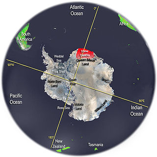
New Swabia was a disputed Antarctic claim by Nazi Germany within the Norwegian territorial claim of Queen Maud Land and is now a cartographic name sometimes given to an area of Antarctica between 20°E and 10°W in Queen Maud Land. New Swabia was explored by Germany in early 1939 and named after that expedition's ship, Schwabenland, itself named after the German region of Swabia.

Axel Heiberg Glacier Glacier in Antarctica

The Axel Heiberg Glacier in Antarctica is a valley glacier, 30 nmi (35 mi) long, descending from the high elevations of the Antarctic Plateau into the Ross Ice Shelf between the Herbert Range and Mount Don Pedro Christophersen in the Queen Maud Mountains.

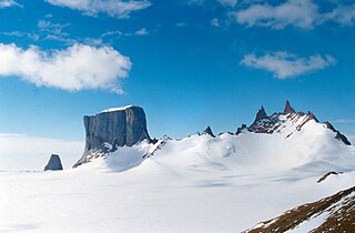
The Sør Rondane Mountains are a group of mountains about 100 miles (160 km) long with main peaks rising to 3400 m, between the Queen Fabiola Mountains and Wohlthat Mountains in Queen Maud Land. They were discovered and photographed from the air by members of the Lars Christensen Expedition (LCE) on February 6, 1937, and named after Rondane, a mountain massif in southern Norway. The mountains and their constituent features were mapped in greater detail and named in 1957 by Norwegian cartographers working with air photos taken by U.S. Navy Operation Highjump, 1946–47.

Jøkulkyrkja Mountain

Jøkulkyrkja Mountain, also known as Massiv Yakova Gakkelya, is a broad, ice-topped mountain with several radial rock spurs, standing east of Lunde Glacier in the Mühlig-Hofmann Mountains of Queen Maud Land, East Antarctica. At 3,148 metres (10,328 ft) elevation, it is the highest elevation in Queen Maud Land, and also the highest elevation within the claims of Norway. The mountain is located on the Princess Astrid Coast of the Norwegian Antarctic Territory. Håhellerskarvet, 2,910 metres (9,550 ft), is located to the southwest; the two peaks are separated by the 25-mile-long Lunde Glacier, which flows to the northwest.

Queen Maud Land Norways territorial claim in Antarctica

Queen Maud Land is a roughly 2.7-million-square-kilometre (1.0-million-square-mile) region of Antarctica claimed by Norway as a dependent territory. It borders the claimed British Antarctic Territory 20° west and the Australian Antarctic Territory 45° east. In addition, a small unclaimed area from 1939 was annexed on 12 June 2015. Positioned in East Antarctica, it makes out about one-fifth of the continent, and is named after the Norwegian queen Maud of Wales (1869–1938).

Mühlig-Hofmann Mountains Mountain range in Antarctica

The Mühlig-Hofmann Mountains is a major group of associated mountain features extending east to west for 100 km (62 mi) between the Gjelsvik Mountains and the Orvin Mountains in Queen Maud Land, East Antarctica. With its summit at 3,148 metres (10,328 ft), the massive Jøkulkyrkja Mountain forms the highest point in the Mühlig-Hofmann Mountains.

Sverdrup Mountains

The Sverdrup Mountains are a group of mountains about 80 km (50 mi) long, standing just west of the Gjelsvik Mountains in Queen Maud Land, East Antarctica. With its summit at 2,855 metres (9,367 ft), Hamartind Peak forms the highest point in the Sverdrup Mountains.

Raudberg in the Norwegian language means Red Mountain. Three terrain features in East Antarctica bear the name Raudberg:

  1. Raudberg Pass
  2. Raudberg Valley
  3. Raudberget

Storkvarvet Mountain is a mountain in Antarctica that is round in plan and has several radial spurs, standing N of Habermehl Peak at the NE end of the Muhlig-Hofmann Mountains, Queen Maud Land.

Mount Neustruyev is a peak in East Antarctica, 2,900 m, standing 5 mi NNE of Gneiskopf Peak in Südliche Petermann Range, Wohlthat Mountains, Queen Maud Land.

Kreitzerisen Glacier in Antarctica

Kreitzerisen is a glacier, 8 nautical miles (15 km) long, flowing north between the Tertene Nunataks and Bamse Mountain in the Sør Rondane Mountains of Antarctica. It was mapped by Norwegian cartographers in 1957 from air photos taken by U.S. Navy Operation Highjump, 1946–47, and named for Lieutenant William R. Kreitzer, U.S. Navy, plane commander on one of the three Operation Highjump aerial crews which photographed this and other coastal areas between 14°E and 164°E.

Koms Glacier Glacier in Antarctica

Koms Glacier is a glacier, 5 nautical miles (9 km) long, flowing north between Mefjell Mountain and Komsa Mountain in the Sør Rondane Mountains of Antarctica. It was mapped by Norwegian cartographers in 1957 from air photos taken by U.S. Navy Operation Highjump, 1946–47, and named Komsbreen.

Gunnestad Glacier Glacier in Antarctica

Gunnestad Glacier is a glacier 13 nautical miles (24 km) long, flowing north between Mount Widerøe and Mount Walnum in the Sør Rondane Mountains of Antarctica. It was mapped by Norwegian cartographers in 1957 from air photos taken by U.S. Navy Operation Highjump, 1946–47, and named for Lieutenant Alf Gunnestad, a pilot with the Norwegian expedition under Lars Christensen, 1933–34.

Gjel Glacier Glacier in Antarctica

Gjel Glacier is a glacier, 17 nautical miles (31 km) long, flowing north between the steep cliffs of the Luncke Range and Mefjell Mountain, in the Sør Rondane Mountains of Antarctica. It was mapped by Norwegian cartographers in 1957 from air photos taken by U.S. Navy Operation Highjump, 1946–47, and named Gjelbreen.

Hargreavesbreen Glacier in Antarctica

Hargreavesbreen is a short, steep glacier flowing northwest between Mount Nils Larsen and Mount Widerøe in the Sør Rondane Mountains of Antarctica. It was mapped by Norwegian cartographers in 1957 from air photos taken by U.S. Navy Operation Highjump, 1946–47, and named for R.B. Hargreaves, an aerial photographer on Operation Highjump photographic flights in this area and other coastal areas between 14°E and 164°E.

Mjell Glacier Glacier in Antarctica

Mjell Glacier is a glacier 9 nautical miles (17 km) long, flowing northeast between Mount Bergersen and Isachsen Mountain in the Sør Rondane Mountains of Antarctica. It was mapped by Norwegian cartographers in 1957 from air photos taken by U.S. Navy Operation Highjump in 1946–47, and named "Mjellbreen".

Mefjell Glacier Glacier in Antarctica

Mefjell Glacier is a glacier, 5 nautical miles (9 km) long, flowing northwest into Gjel Glacier between Menipa Peak and Mefjell Mountain in the Sør Rondane Mountains of Antarctica. It was mapped by Norwegian cartographers in 1957 from air photos taken by U.S. Navy Operation Highjump, 1946–47, and named Mefjellbreen.

Hette Glacier Glacier in Antarctica

Hette Glacier is a glacier, 6 nautical miles (11 km) long, flowing north between the Hettene Nunataks and Austhamaren Peak in the Sør Rondane Mountains of Antarctica. It was mapped by Norwegian cartographers in 1957 from air photos taken by U.S. Navy Operation Highjump, 1946–47, and named Hettebreen.

References

  1. 1 2 Birgit Njåstad: «Antarktis - norsk natur- og kulturminneforvaltning» Rapportserie No. 112, Norwegian Polar Institute, Tromsø 1999, p. 17
  2. "Isachsen Mountain". Geographic Names Information System . United States Geological Survey . Retrieved 2013-01-22.
  3. "Devold Peak". Geographic Names Information System . United States Geological Survey . Retrieved 2013-01-22.
  4. "Kjelbotn Peak". Geographic Names Information System . United States Geological Survey . Retrieved 2013-01-22.
  5. "Bond Peaks". Geographic Names Information System . United States Geological Survey . Retrieved 2013-01-22.
  6. "Widerøe, Mount". Geographic Names Information System . United States Geological Survey . Retrieved 2013-01-22.
  7. Background information on the Sør Rondane Mountains Belgian Research Station Antarctica
  8. Norwegian Polar Institute map archive
  9. 1 2 3 4 5 6 7 8 9 10 11 12 13 14 15 16 17 18 19 20 21 22 23 24 25 26 27 28 29 30 31 32 33 34 35 36 37 38 39 40 41 42 43 44 45 46 47 48 49 50 51 52 53 54 55 56 57 58 59 60 61 62 63 64 65 66 67 68 69 70 71 72 73 74 75 76 77 78 79 80 81 82 83 84 85 86 87 88 89 90 91 92 93 94 95 96 Geographic Names Information System (GNIS)
  10. 1 2 3 4 5 6 7 8 9 10 11 12 13 14 15 16 17 18 19 20 21 22 23 24 25 26 27 28 29 30 31 32 33 34 35 36 37 38 39 40 41 42 43 44 45 46 47 48 49 50 51 52 53 54 55 56 57 58 59 60 61 62 63 64 65 66 67 68 69 70 71 72 73 74 75 76 77 78 79 80 81 82 83 84 85 86 87 88 89 90 91 92 93 94 95 96 97 98 99 100 101 102 103 104 105 106 107 108 109 110 111 112 113 114 115 116 117 118 119 120 121 122 123 124 125 126 127 128 129 130 131 132 133 134 135 136 137 138 139 140 141 142 143 144 145 146 147 148 149 150 151 152 153 154 155 156 157 158 159 160 161 162 163 164 165 166 167 168 169 170 171 172 173 174 175 176 177 178 179 180 181 182 183 184 185 186 187 188 189 190 191 192 193 194 195 196 197 198 199 200 201 202 203 204 205 206 207 208 209 210 211 212 213 214 215 216 217 218 219 220 221 222 223 224 225 226 227 228 229 230 231 232 233 234 235 236 237 238 239 240 241 242 243 244 245 246 247 248 249 250 251 252 253 254 255 256 257 258 259 260 261 262 263 264 265 266 267 268 269 270 271 272 273 274 275 276 277 278 279 280 281 282 283 284 285 286 287 288 289 290 291 292 293 294 295 296 297 298 299 300 301 302 303 304 305 306 307 308 309 310 311 312 313 314 315 316 317 318 319 320 Norway Gazetteer of Antarctica
  11. Engelskjøn, Torstein (1986). "Botany of two Antarctic mountain ranges: Gjelsvikfjella and Mühlig-Hofmannfjella, Dronning Maud Land. I. General ecology and development of the Antarctic cold desert cryptogam formation." Archived 2016-03-04 at the Wayback Machine Polar Research 4 n.s., p. 208.
  12. 1 2 3 Brunk, K.(1986): Kartographische Arbeiten und deutsche Namengebung in Neuschwabenland, Antarktis Archived 2014-01-16 at the Wayback Machine . - Deutsche Geodätische Kommission, Series E: Volume 24, Part I Annex 2, Frankfurt am Main
  13. 1 2 3 4 5 6 7 8 9 10 11 12 13 14 15 16 17 18 19 20 21 22 23 24 25 26 27 28 29 30 31 32 33 34 35 36 37 38 39 40 Belgian toponyms in Antarctica Belgian Science Policy. Retrieved 2015-01-21.
  14. 1 2 3 4 5 6 7 8 9 10 11 12 13 Japan Gazetteer of Antarctica