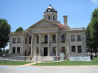
Poinsett County is a county located in the U.S. state of Arkansas. As of the 2010 census, the population was 24,583. The county seat is Harrisburg.

Chicot County is a county located in the U.S. state of Arkansas. As of the 2010 census, the population was 11,800. The county seat is Lake Village. Chicot County is Arkansas's 10th county, formed on October 25, 1823, and named after Point Chicot on the Mississippi River. It is part of the Arkansas Delta, lowlands along the river that have been historically important as an area for large-scale cotton cultivation.
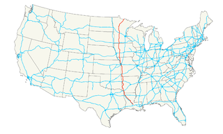
U.S. Route 71 is a major north–south United States highway that extends for over 1500 miles in the central United States. This original 1926 route has remained largely unchanged by encroaching Interstate highways. Currently, the highway's northern terminus is in International Falls, Minnesota at the Canada–US border, at the southern end of the Fort Frances-International Falls International Bridge to Fort Frances, Ontario. U.S. Route 53 also ends here. On the other side of the bridge, Trans-Canada Highway 11 is an east–west route. US 71's southern terminus is between Port Barre and Krotz Springs, Louisiana at an intersection with U.S. Route 190.

U.S. Route 165 is a north–south United States highway spur of U.S. Highway 65. It currently runs for 412 miles (663 km) from U.S. Route 90 in Iowa, Louisiana north to U.S. Highway 70 in North Little Rock, Arkansas. The route passes through the states of Arkansas and Louisiana. It passes through the cities of Monroe and Alexandria in Louisiana. A segment of US 165 serves as a routing of the Great River Road within Arkansas.

State Road 2 is a former east–west state highway in the Arkansas Timberlands and Lower Arkansas Delta. The route was approximately 195 miles (314 km), and ran from US Route 67 (US 67) in Texarkana east to cross the Mississippi River near Lake Village, continuing as Mississippi Highway 10. On July 1, 1931, the route was entirely replaced by US Highway 82 (US 82) by the American Association of State Highway Officials (AASHTO). The route was maintained by the Arkansas Highway Department (AHD), now known as the Arkansas Department of Transportation (ArDOT).
Interstate 40 (I-40) is an east–west Interstate Highway that has a 284.69-mile (458.16 km) section in the U.S. state of Arkansas connecting Oklahoma to Tennessee. The route enters Arkansas from the west just north of the Arkansas River near Dora. It travels eastward across the northern portion of the state connecting the cities of Fort Smith, Clarksville, Russellville, Morrilton, Conway, Little Rock, Forrest City, and West Memphis. I-40 continues into Tennessee heading through Memphis. The highway has major junctions with Interstate 540 at Van Buren, Interstate 49 at Alma, Interstate 30 in Little Rock, and Interstate 55 to Blytheville.
U.S. Highway 82 in Arkansas is a major east–west arterial highway across the state's lowest tier of counties. It enters Arkansas from Texas, concurrent with US Highway 67, at a junction with US Highway 71 on the border between Texarkana, Texas and Texarkana, Arkansas. The route leaves Arkansas on the Lake Village Bridge over the Mississippi River near Lake Village, crossing into Mississippi.

Athelstan is an unincorporated community in Mississippi County, Arkansas, United States. Athelstan is located at the junction of Arkansas highways 77 and 140, 11.5 miles (18.5 km) west of Osceola.
Poplar Corner is an unincorporated community in Mississippi County, Arkansas, United States. Poplar Corner is located at the junction of Arkansas highways 77 and 119, 3 miles (4.8 km) north of Manila.
Dimple is an unincorporated community in Mississippi County, Arkansas, United States. Dimple is located at the junction of Arkansas highways 77 and 308, 1 mile (1.6 km) northeast of Birdsong.
Denwood is an unincorporated community in Mississippi County, Arkansas, United States. Denwood is located on Arkansas Highway 77, 6 miles (9.7 km) west-southwest of Joiner.
Arkmo is an unincorporated community located in both Mississippi County, Arkansas and Dunklin County, Missouri United States. Arkmo is situated at the junction of Arkansas Highway 77 and Missouri Route 108, 3.5 miles (5.6 km) south of Arbyrd; the community primarily lies on the Missouri side of the border.
Midway is an unincorporated community in Mississippi County, Arkansas, United States. Midway is located on Arkansas Highway 181, 7 miles (11 km) west-northwest of Blytheville.
Tomato is an unincorporated community in Mississippi County, Arkansas, United States. Tomato is located on Island No. 25 in the Mississippi River, 11.5 miles (18.5 km) east-southeast of Blytheville. Tomato is known for its unusual place name.
Sans Souci is an unincorporated community in Mississippi County, Arkansas, United States. Sans Souci is located on Arkansas Highway 198, 3.75 miles (6.04 km) south-southeast of Osceola.
Calumet is an unincorporated community in Mississippi County, Arkansas, United States. Calumet is located at the junction of Arkansas highways 151 and 181 on the northeast border of Gosnell.
Pecan Point is an unincorporated community in Mississippi County, Arkansas, United States. Pecan Point is located on Arkansas Highway 118, 6.4 miles (10.3 km) east-southeast of Joiner.
Number Nine is an unincorporated community in Mississippi County, Arkansas, United States. Number Nine is located on Arkansas Highway 150, 7.5 miles (12.1 km) east-northeast of Blytheville.


