Morpeth is a historic market town in Northumberland, England, lying on the River Wansbeck. Nearby towns include Ashington and Bedlington. In the 2011 census, the population of Morpeth was given as 14,017, up from 13,833 in the 2001 census. The earliest evidence of settlement is believed to be from the Neolithic period, and some Roman artifacts have also been found.

Glanton is a small rural village, in the county of Northumberland, England. Agriculture dominates the surrounding area.

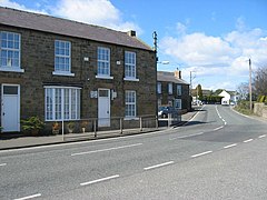
Hartburn is a village in Northumberland, in England. It is situated about 6 miles (10 km) to the west of Morpeth. The population at the 2011 census was 194.

Berrington is a village in Northumberland, in England. It is situated to the south of Berwick-upon-Tweed, inland from the North Sea coast.

Bowsden is a village and civil parish in Northumberland, England. It is about 6 miles (10 km) to the south of Berwick-upon-Tweed, inland from the North Sea coast at Lindisfarne, and has a population of 157, rising to 178 at the 2011 Census.

Callaly is a village and civil parish in Northumberland, England. It is about 9 miles (14 km) to the west of Alnwick. The main A697 road is 3 miles (5 km) away. It is on the line of the Roman road linking the Roman forts of High Rochester to the west and Learchild to the east, where it joins the Devil's Causeway Roman road to the north. The parish includes the hamlets of Lorbottle and Yetlington.

Capheaton is a village and civil parish in Northumberland, England, about 25 miles (40 km) to the northwest of Newcastle upon Tyne. The population at the 2001 census was 160, increasing to 175 at the 2011 Census. It was built as a planned model village in the late eighteenth century. The name Capheaton derives from Caput Heaton, i.e., Heaton Magna, nearby Kirkheaton being the original Heaton Parva.

Matfen is a village and a civil parish in Northumberland, England, near the town of Hexham and the city of Newcastle upon Tyne. It is an example of a 19th-century planned estate village. It was the birthplace of the 7th Premier of British Columbia, William Smithe. In 2001 it had a population of 495.

Edlingham is a small village and civil parish in Northumberland in the north of England. At the 2001 census it had a population of 196, which had reduced slightly to 191 at the 2011 Census. The road to Alnwick passes close by the village and the town of Rothbury is about 6 miles (10 km) away.

Powburn is a small village on the A697 in Northumberland, England about 8 miles (13 km) south of Wooler and 10 miles (16 km) northwest of Alnwick.

Longframlington is a small village in Northumberland, England, located on the A697, 11 miles (18 km) north-west of Morpeth and 5 miles (8 km) south-east of Rothbury. Longframlington is a former pit village and on the site of the pit now stands Fram Park, a log cabin holiday park. The village was previously the site of the Longframlington Music Festival.

The A697 is a road that can be used an alternative to the A1 for those travelling between Scotland and England via the North East.
Middleton is a settlement and civil parish in Northumberland, England. The parish is situated on the North Sea coast, south of the island of Lindisfarne, and contains the villages of Ross, Detchant and Elwick; all are shrunken medieval villages. Both the A1 London to Edinburgh road and East Coast Main Line pass through the parish. In the 2001 census the parish had a population of 136, falling to 115 at the 2011 Census.

Kirkheaton is a village and former civil parish, now in the parish of Capheaton, in the county of Northumberland, England. The village lies about 10 miles (16 km) north east of Hexham and about 5 miles (8 km) west of Belsay. In 1951 the parish had a population of 70.

Netherwitton is a village in Northumberland, England about 8 miles (13 km) west north west of Morpeth.

Horton is a pair of small settlements, West Horton and East Horton, divided by a stream - the Horton Burn - in Northumberland, England 3 miles (5 km) north east of Wooler and 5 miles (8 km) west of Belford.

The Devil's Causeway is a Roman road in Northumberland, in North East England. It branches off Dere Street north of Corbridge and can be traced through Northumberland for about 55 miles (89 km) north to Berwick-upon-Tweed.