Läkumätas

Last updated

Läkumätas is an island in Lääne-Saare Parish, Saare County, Estonia.

Lääne-Saare Parish Former municipality of Estonia in Saare County

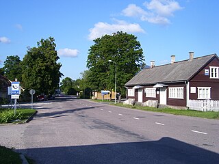
Lääne-Saare Parish was a rural municipality of Estonia, in Saare County. It was located on the western part of Saaremaa island. The municipality has a population of ca 7,200 and an area of 807 km².

Saare County County of Estonia

Saare County, or Saaremaa; is one of 15 counties of Estonia. It consists of Saaremaa, the largest island of Estonia, and several smaller islands near it, most notably Muhu, Ruhnu, Abruka and Vilsandi. The county borders Lääne County to the east, Hiiu County to the north, and Latvia to the south.. In January 2013 Saare County had a population of 30,966, constituting 2.4% of the population of Estonia.

Estonia Republic in Northern Europe

Estonia, officially the Republic of Estonia, is a country in Northern Europe. It is bordered to the north by the Gulf of Finland with Finland on the other side, to the west by the Baltic Sea with Sweden on the other side, to the south by Latvia (343 km), and to the east by Lake Peipus and Russia (338.6 km). The territory of Estonia consists of a mainland and 2,222 islands in the Baltic Sea, covering a total area of 45,227 km2 (17,462 sq mi), water 2,839 km2 (1,096 sq mi), land area 42,388 km2 (16,366 sq mi), and is influenced by a humid continental climate. The official language of the country, Estonian, is the third most spoken Finno-Ugric language.

See also

Coordinates: 58°13′39″N22°32′23″E / 58.22750°N 22.53972°E / 58.22750; 22.53972

Geographic coordinate system Coordinate system

A geographic coordinate system is a coordinate system that enables every location on Earth to be specified by a set of numbers, letters or symbols. The coordinates are often chosen such that one of the numbers represents a vertical position and two or three of the numbers represent a horizontal position; alternatively, a geographic position may be expressed in a combined three-dimensional Cartesian vector. A common choice of coordinates is latitude, longitude and elevation. To specify a location on a plane requires a map projection.

Related Research Articles

Kaarma is a village in Saaremaa Parish, Saare County, on the island of Saaremaa, Estonia.

Sutu is a village in Saaremaa Parish, Saare County, on the island of Saaremaa, Estonia.

Uduvere is a village in Saaremaa Parish, Saare County, on the island of Saaremaa, Estonia.

Kihelkonna Small borough in Saare, Estonia

Kihelkonna is a small borough in Saare County, on the western part of Saaremaa Island, Estonia. It was the administrative centre of Kihelkonna Parish.

Veske is a village in Saaremaa Parish, Saare County, on the island of Saaremaa Estonia.

Ratla is a village in Saaremaa Parish, Saare County, on the island of Saaremaa Estonia.

Asuküla is a village in Saaremaa Parish, Saare County in western Estonia.

Eikla is a village in Saaremaa Parish, Saare County in western Estonia.

Parila is a village in Saaremaa Parish, Saare County in western Estonia.

Piila is a village in Saaremaa Parish, Saare County in western Estonia.

Sepa is a village in Saaremaa Parish, Saare County in western Estonia.

Tõrise is a village in Saaremaa Parish, Saare County in western Estonia.

Hirmuste is a village in Saaremaa Parish, Saare County in western Estonia.

Käesla is a village in Saaremaa Parish, Saare County in western Estonia.

Mätasselja is a village in Saaremaa Parish, Saare County in western Estonia.

Aru is a village in Saaremaa Parish, Saare County in western Estonia.

Koimla is a village in Saaremaa Parish, Saare County in western Estonia.

Koki is a village in Saaremaa Parish, Saare County in western Estonia.

Mõndelaid is a 0.2694 ha islet on the western coast of Saaremaa island, Estonia. Administratively it belongs to Jõgela village, Lääne-Saare Parish, Saare County.

Väike-Tulpe is an island in Lääne-Saare Parish, Saare County, Estonia.