
The Republic of Equatorial Guinea is located in west central Africa. Bioko Island lies about 40 kilometers (24.9 mi) from Cameroon. Annobón Island lies about 595 kilometres (370 mi) southwest of Bioko Island. The larger continental region of Río Muni lies between Cameroon and Gabon on the mainland; it includes the islands of Corisco, Elobey Grande, Elobey Chico, and adjacent islets. The total land area is 28,051 km2 (10,831 sq mi). It has an Exclusive Economic Zone of 303,509 km2 (117,185 sq mi).
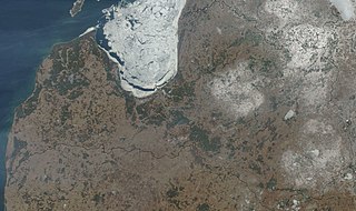
Latvia lies on the eastern shores of the Baltic Sea on the level northwestern part of the rising East European platform, between Estonia and Lithuania. About 98% of the country lies under 200 m (656 ft) elevation. With the exception of the coastal plains, the ice age divided Latvia into three main regions: the morainic Western and Eastern uplands and the Middle lowlands. Latvia holds over 12,000 rivers, only 17 of which are longer than 100 km (60 mi), and over 3,000 small lakes, most of which are eutrophic. The major rivers include the Daugava, the Lielupe, the Gauja, the Venta and the Salaca. Woodlands cover around 52% of the country. Other than peat, dolomite, and limestone, natural resources are scarce. Latvia has 504 km (313 mi) of sandy coastline, and the ports of Liepāja and Ventspils provide important warm-water harbors for the Baltic coast.

Sudan is located in Northeast Africa. It is bordered by Egypt to the north, the Red Sea to the northeast, Eritrea and Ethiopia to the east, South Sudan to the south, the Central African Republic to the southwest, Chad to the west and Libya to the northwest. Sudan is the third largest country in Africa, after Algeria and the Democratic Republic of the Congo. It was the largest country on the continent until South Sudan split off from it in 2011.

The Kingdom of Bahrain consists of Bahrain Island and 33 of the 37 Bahrain Islands, lying in the Persian Gulf's Gulf of Bahrain off the north shore of West Asia's Arabian Peninsula. Bahrain's capital city is Manama. The islands are about 24 kilometers (15 mi) off the east coast of Saudi Arabia and 28 kilometers (17 mi) from Qatar. The total area of the country is about 694 square kilometers (268 sq mi), about four times the size of the District of Columbia.
Abuko is a town in the West Coast Division of the Gambia, five miles southwest of the capital Banjul. It is located in the district of Kombo North/Saint Mary to the north of Banjul International Airport and Abuko Nature Reserve.

Héliopolis, Algeria is a town and commune in Guelma Province, Algeria. According to the 1998 census it has a population of 22,605.
The Jeneberang is a river of approximately 75 km in length in the south-western half of the island of Sulawesi, Indonesia. The catchment has an area of 760 square kilometers.
The Telen River is a river in East Kalimantan, Borneo island, Indonesia, about 110 kilometers north of the provincial capital Samarinda. It is a tributary of the Mahakam River.
The Sembakung River is a river in Borneo that flows from Sabah, Malaysia to North Kalimantan, Indonesia, about 1600 km northeast of the capital Jakarta.
Kūh-Zibad its peak also called Tir Mahi is a mountain in the province of Razavi Khorasan, city of Gonabad District Zibad in the eastern part of the country, 700 km east of the capital Tehran. The Peak of the Moantain is called Qole -e Tir Mahi is 2,557 metres (8,389 ft) above sea level, or 431 m (1,414 ft) above the surrounding terrain. The width at the base is 5.5 km. The terrain around the Qole-e Tir Mahi and Kuh-e zibad is mainly hilly. The highest point in the vicinity is 2775 meters above sea level, 17.7 km southeast of Qole-e Tir mahi. Around Kuh-e Zibad is very sparsely populated, with 5 inhabitants per square kilometer. Nearest society zibad, 8.5 km north of Kuh-e Zibad. The neighborhood around Kuh-e Zibad is barren with little or vegetation. In the neighborhood around the Kuh-e Zibad are unusually many named mountains and valleys. A cold steppe climate prevailing in the region. The average annual temperature in the area is 17 °C. The warmest month is July when the average temperature is 30 °C, and the coldest is January, with 1 °C. Average annual rainfall is 211 mm (8 in). The rainiest month is February, with an average of 58 mm (2 in) of precipitation, and the driest is July, with 1 mm of precipitation. This mountain had been referred in some historical book such as shahnameh in Davazdah Rokhwar as the Zibad mountain and its eastern part is called black mountain or kuh Gonabad. The long mountain range is called Qohestan and it extends from Bajestan to Birjand near the border with Afghanistan. This mountain range separates south khorasan from Razavi Khorasan, part of this mountain range near Kakhk is called black mountain or kuh e gonabad.

Mount Greenly is a mountain in Australia located in the state of South Australia on the Eyre Peninsula in the gazetted locality of Coulta. The top of Mount Greenly is 305 metres (1,001 ft) above sea level.
Banalia is a territory and a locality of Tshopo province in the Democratic Republic of the Congo. It is located in the north-central part of the country, 1,300 km northeast of the capital Kinshasa.
Irumu is a territory of Ituri province, Democratic Republic of the Congo. It is located in the northeastern part of the country, 1,700 km east of the capital Kinshasa. Its administrative center is the town of Irumu.

Sawridge 150H is an Indian reserve of the Sawridge First Nation in Alberta, located within the Municipal District of Lesser Slave River No. 124. It is west of the town of Slave Lake.
Tall Sulaymānī is a hill in Syria. It is located in al-Hasakah province, in the northeastern part of the country, 500 kilometers northeast of the capital Damascus. The peak of Tall Sulaymānī is 304 meters above sea level.
Mount Boboiob is a mountain in Tajikistan. It is located in the Sughd Region, in the northern part of the country, 290 km northeast of Dushanbe, the country's capital. The mountain is 3,747 meters above sea level.

Xino Nero is a village in the municipality Amyntaio, within the regional unit of Florina. The village is built at a height of 550 meters. According to the 2021 census, the population of the village amounts to 907 inhabitants. The main occupation of the inhabitants is agriculture and animal husbandry. It is 34 km from Florina and 5 from Amyntaio.
Changchun (长春镇) is a town in Xiapu County, Fujian.
Shuimen She Ethnic Township (水门畲族乡) is a township in Xiapu County, Fujian, China.
Chongru She Ethnic Township (崇儒畲族乡) is an ethnic township in Xiapu County.
